Maps of Wrexham

Bala and Welshpool - OS One-Inch Map
1 : 63360 Topographic maps Ordnance Survey Ordnance Survey
Oswestry
1 : 31680 This drawing is formally titled. The scale of the drawing isgiven and the area of the land noted as 145.9838 square miles., A triangulation diagram appears on the reverse of the manuscript., This enabled draughtsmen to plot the exact location of topographical features., Archaeological sites are named in gothic script., Colour washes are combined with numerical annotations to indicate the relative relief and overall height of hills. Dawson, Robert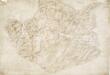
Llanerfyl
1 : 31680 The formal title of the drawing states that Robert Dawson supervised the surveyor. Dawson, one of the best surveyors and draughtsmen, was employed on the Ordnance Survey for over forty years, working also as an instructor. The scale of the drawing is noted and the area of the land recorded as 165.4742 square miles. A triangulation diagram appears on the reverse. This enabled draughtsmen to plot the exact location of topographical features. Colour washes depicting relief are combined with numerical annotations ('spot heights') in black ink indicating the heights of hills. The draughtsman has also distinguished between the representation of coniferous and deciduous trees. Hall, Joseph
Llangynog
1 : 31680 The scale of the drawing is noted, and the area mapped recorded as 67.5371 square miles. Archaeological sites are named in gothic script. Colour washes are combined with numerical annotations to indicate the relative relief and height of the hills. Collard, Thomas W
Meifod
1 : 31680 A triangulation diagram appears on the reverse of this drawing. This allowed draughtsmen to plot the exact location of prominent features of the landscape. Archaeological sites are named in gothic script.Black ink numbers indicate the heights of the hills. Still, Henry
Dinas-Mawddwy (Hills) - OS One-Inch Revised New Series
1 : 63360 Topographic maps Ordnance Survey Ordnance Survey
Dinas-Mawddwy (Outline) - OS One-Inch Revised New Series
1 : 63360 Topographic maps Ordnance Survey Ordnance Survey
Bala (Hills) - OS One-Inch Revised New Series
1 : 63360 Topographic maps Ordnance Survey Ordnance Survey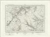
Bala (Outline) - OS One-Inch Revised New Series
1 : 63360 Topographic maps Ordnance Survey Ordnance Survey
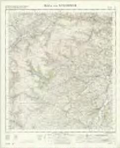
Bala
1 : 31680 This drawing shows part of the Cambrian Mountains in north west Wales. An area calculation table survives in black ink in the bottom right margin beneath the formal title. Colour washes depicting relief are combined with numerical annotations of the heights of the hills. The author of the drawing, Robert Dawson, explains that these altitudes were trigonometrically ascertained, "except those distinguished by a note of interrogation, which are only a judgement." One of the best surveyors and draughtsmen, Dawson was employed on the Ordnance Survey for over forty years, also working as an instructor. Dawson, Robert
Llandrillo
1 : 31680 This,original protraction is formally titled. The traverse routes are noted with the relevant dates and Ordnance Survey field-book page numbers. The conventional sign of a dot within a triangle indicates a trigonometrical point. These appear around the edges of the drawing in red ink,,marking the points from which the surveyor took angular measurements to plot features of the landscape. , Collard, Thomas W.
Llangollen
1 : 31680 A triangulation diagram appears on the reverse of this drawing. This enabled draughtsmen to plot the exact location of topographical features. Mileage is indicated on major communication routes, accompanied by abbreviations of the town names from which distance has been measured. For example, the abbreviation 'MS L''2' indicates two miles from Llangollen. Archaeological sites are named in gothic script. A triangulation grid is faintly visible in the left hand portion of the drawing, and pencil lines radiate from trigonometrical stations, marked by dots within triangles. Durrant, William R
Oswestry (Hills) - OS One-Inch Revised New Series
1 : 63360 Topographic maps Ordnance Survey Ordnance Survey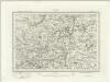
Oswestry (Outline) - OS One-Inch Revised New Series
1 : 63360 Topographic maps Ordnance Survey Ordnance Survey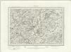
Welshpool (Outline) - OS One-Inch Revised New Series
1 : 63360 Topographic maps Ordnance Survey Ordnance Survey
Welshpool (Hills) - OS One-Inch Revised New Series
1 : 63360 Topographic maps Ordnance Survey Ordnance Survey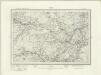
Corwen (Outline) - OS One-Inch Revised New Series
1 : 63360 Topographic maps Ordnance Survey Ordnance Survey
Corwen (Hills) - OS One-Inch Revised New Series
1 : 63360 Topographic maps Ordnance Survey Ordnance Survey
SH94 - OS 1:25,000 Provisional Series Map
1 : 25000 Topographic maps Ordnance Survey Ordnance Survey
SH93 - OS 1:25,000 Provisional Series Map
1 : 25000 Topographic maps Ordnance Survey Ordnance Survey
SH92 - OS 1:25,000 Provisional Series Map
1 : 25000 Topographic maps Ordnance Survey Ordnance Survey
SJ04 - OS 1:25,000 Provisional Series Map
1 : 25000 Topographic maps Ordnance Survey Ordnance Survey
SH91 - OS 1:25,000 Provisional Series Map
1 : 25000 Topographic maps Ordnance Survey Ordnance Survey
SJ03 - OS 1:25,000 Provisional Series Map
1 : 25000 Topographic maps Ordnance Survey Ordnance Survey
SH90 - OS 1:25,000 Provisional Series Map
1 : 25000 Topographic maps Ordnance Survey Ordnance Survey
SJ02 - OS 1:25,000 Provisional Series Map
1 : 25000 Topographic maps Ordnance Survey Ordnance Survey
SJ14 - OS 1:25,000 Provisional Series Map
1 : 25000 Topographic maps Ordnance Survey Ordnance Survey
SJ01 - OS 1:25,000 Provisional Series Map
1 : 25000 Topographic maps Ordnance Survey Ordnance Survey
SJ13 - OS 1:25,000 Provisional Series Map
1 : 25000 Topographic maps Ordnance Survey Ordnance Survey