Maps of Dumfries

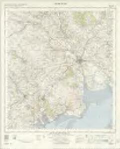
Dumfries - OS One-Inch Map
1 : 63360 Topographic maps Ordnance Survey Ordnance Survey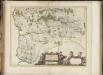
Praefectura Kircubriensis quae Gallovidiae maxime orientalis pars est. The Stuartrie of Kircubright, the most easterlie part of Galloway / auct. Tim. Pont.
Pont, Timothy, 1560?-1614? Blaeu, Joan, 1596-1673
The East Part of Galloway : being Part of the Shire of Kirkcudbright / by H. Moll.
Moll, Herman, d. 1732
Præfectvra Kircvbriensis, quæ Gallovidiæ maxime orientalis pars est
1 Karte : Kupferdruck ; 41 x 53 cm Blaeu; Pont Joan Blaeu
The Shire of Dumfries or Nithisdale / by H. Moll.
Moll, Herman, d. 1732
Dalbeattie - OS One-Inch Map
1 : 63360 Topographic maps Ordnance Survey Ordnance Survey
Dumfries (88) - OS One-Inch map
1 : 63360 Topographic maps Ordnance Survey Ordnance Survey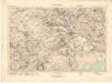
Dumfries (88) - OS One-Inch map
1 : 63360 Topographic maps Ordnance Survey Ordnance Survey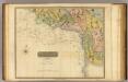
Dumfriesshire 3 S.
1 : 64000 Crawford & Son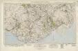
Castle Douglas & Kirkcudbright (92) - OS One-Inch map
1 : 63360 Topographic maps Ordnance Survey Ordnance Survey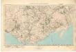
Castle Douglas & Kirkcudbright (92) - OS One-Inch map
1 : 63360 Topographic maps Ordnance Survey Ordnance Survey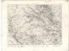
Maxwelltown - OS One-Inch map
1 : 63360 Topographic maps Ordnance Survey Ordnance Survey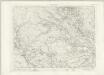
Maxwelltown - OS One-Inch map
1 : 63360 Topographic maps Ordnance Survey Ordnance Survey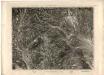
Maxwelltown - OS One-Inch map
1 : 63360 Topographic maps Ordnance Survey Ordnance Survey
Kirkcudbright - OS One-Inch map
1 : 63360 Topographic maps Ordnance Survey Ordnance Survey
Kirkcudbright - OS One-Inch map
1 : 63360 Topographic maps Ordnance Survey Ordnance Survey
[Kirkcudbright] - OS One-Inch map
1 : 63360 Topographic maps Ordnance Survey Ordnance Survey
Volume 1: Sheet 5 - Kirkcudbright
1 : 63360 Farquharson, J.
Silloth (Hills) - OS One-Inch Revised New Series
1 : 63360 Topographic maps Ordnance Survey Ordnance Survey
Silloth (Outline) - OS One-Inch Revised New Series
1 : 63360 Topographic maps Ordnance Survey Ordnance Survey
NX79 - OS 1:25,000 Provisional Series Map
1 : 25000 Topographic maps Ordnance Survey Ordnance Survey
NX78 - OS 1:25,000 Provisional Series Map
1 : 25000 Topographic maps Ordnance Survey Ordnance Survey
NX77 - OS 1:25,000 Provisional Series Map
1 : 25000 Topographic maps Ordnance Survey Ordnance Survey
NX76 - OS 1:25,000 Provisional Series Map
1 : 25000 Topographic maps Ordnance Survey Ordnance Survey
NX88 - OS 1:25,000 Provisional Series Map
1 : 25000 Topographic maps Ordnance Survey Ordnance Survey
NX75 - OS 1:25,000 Provisional Series Map
1 : 25000 Topographic maps Ordnance Survey Ordnance Survey
NX87 - OS 1:25,000 Provisional Series Map
1 : 25000 Topographic maps Ordnance Survey Ordnance Survey
NX86 - OS 1:25,000 Provisional Series Map
1 : 25000 Topographic maps Ordnance Survey Ordnance Survey
NX98 - OS 1:25,000 Provisional Series Map
1 : 25000 Topographic maps Ordnance Survey Ordnance Survey