Maps of Dumfries and Galloway
Kirkcudbrightshire, Sheet 055.02 - 25 Inch Map
1 : 2500 Topographic maps Ordnance Survey Ordnance Survey
Kirkcudbrightshire, Sheet 055.02 - 25 Inch Map
1 : 2500 Topographic maps Ordnance Survey Ordnance Survey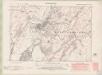
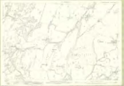
Kirkcudbrightshire Sheet LV.NW - OS 6 Inch map
1 : 10560 Topographic maps Ordnance Survey Ordnance Survey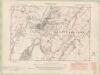
Kirkcudbrightshire Sheet LV.NW - OS 6 Inch map
1 : 10560 Topographic maps Ordnance Survey Ordnance Survey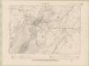
Kirkcudbrightshire Sheet LV.NW - OS 6 Inch map
1 : 10560 Topographic maps Ordnance Survey Ordnance Survey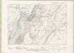
Kirkcudbrightshire Sheet LV.NW - OS 6 Inch map
1 : 10560 Topographic maps Ordnance Survey Ordnance Survey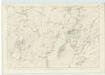
Kirkcudbrightshire, Sheet 50 - OS 6 Inch map
1 : 10560 Topographic maps Ordnance Survey Ordnance Survey
Plan of the Town of Kirkcudbright.
Wood, John, ca. 1780-1847 James Turner & Co.
Kirkcudbright
Great Britain. Parliament. House of Commons.
Kirkcudbright Bay
Great Britain. Hydrographic Office
Volume 1: Sheet 5 - Kirkcudbright
1 : 63360 Farquharson, J.
Kirkcudbright - OS One-Inch map
1 : 63360 Topographic maps Ordnance Survey Ordnance Survey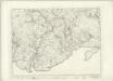
Kirkcudbright - OS One-Inch map
1 : 63360 Topographic maps Ordnance Survey Ordnance Survey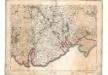
[Kirkcudbright] - OS One-Inch map
1 : 63360 Topographic maps Ordnance Survey Ordnance Survey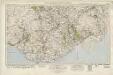
Castle Douglas & Kirkcudbright (92) - OS One-Inch map
1 : 63360 Topographic maps Ordnance Survey Ordnance Survey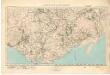
Castle Douglas & Kirkcudbright (92) - OS One-Inch map
1 : 63360 Topographic maps Ordnance Survey Ordnance Survey
The Middle Part of Galloway : Contains The West P. of Kirkcudbright Shire / by H. Moll.
Moll, Herman, d. 1732
The East Part of Galloway : being Part of the Shire of Kirkcudbright / by H. Moll.
Moll, Herman, d. 1732
Præfectvra Kircvbriensis, quæ Gallovidiæ maxime orientalis pars est
1 Karte : Kupferdruck ; 41 x 53 cm Blaeu; Pont Joan Blaeu
Dalbeattie - OS One-Inch Map
1 : 63360 Topographic maps Ordnance Survey Ordnance Survey
Dumfries - OS One-Inch Map
1 : 63360 Topographic maps Ordnance Survey Ordnance Survey
Kirkcudbright - OS One-Inch Map
1 : 63360 Topographic maps Ordnance Survey Ordnance Survey
New Galloway - OS One-Inch Map
1 : 63360 Topographic maps Ordnance Survey Ordnance Survey
GALLOVIDIÆ PARS MEDIA, | quæ Deam et Cream fluvios interjacet. | The Middle-part of Galloway, | whiche lyeth betweene the rivers Dee and Cree.
Auct. Tim. Pont. [Amsterdam : Joan Blaeu]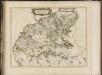
Gallovidiae pars media quae Deam et Cream fluvios interjacet, [vulgo], The Middle part of Galloway, which lyeth betweene the rivers Dee and Cree / auct. Timoth. Pont.
Pont, Timothy, 1560?-1614? Blaeu, Joan, 1596-1673
Wigtown - Bartholomew's 'Survey Atlas of Scotland'
1 : 126720 Topographic maps John Bartholomew & Son, Ltd John Bartholomew & Son, Ltd
Gallovidiæ pars media, quæ Deam et Cream fluvios interjacet
1 Karte : Kupferdruck ; 41 x 53 cm Blaeu; Pont Joan Blaeu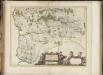
Praefectura Kircubriensis quae Gallovidiae maxime orientalis pars est. The Stuartrie of Kircubright, the most easterlie part of Galloway / auct. Tim. Pont.
Pont, Timothy, 1560?-1614? Blaeu, Joan, 1596-1673
The Stewartry of Kirkcudbright.
Ainslie, John, 1745-1828
The Stewartry of Kirkcudbright.
Ainslie, John, 1745-1828
The Stewartry of Kirkcudbright.
Ainslie, John, 1745-1828