Maps of Highland
Ross and Cromarty Sheet XLVIII - OS 6 Inch map
1 : 10560 Topographic maps Ordnance Survey Ordnance Survey
Ross-shire & Cromartyshire (Mainland), Sheet XLVIII - OS 6 Inch map
1 : 10560 Topographic maps Ordnance Survey Ordnance Survey
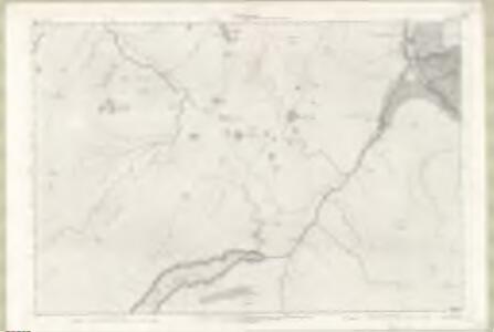
Ross and Cromarty, Sheet XLVIII.4 (Lochbroom) - OS 25 Inch map
1 : 2500 Topographic maps Ordnance Survey Ordnance Survey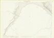
Ross-shire, Sheet 048.08 - 25 Inch Map
1 : 2500 Topographic maps Ordnance Survey Ordnance Survey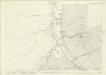
Ross-shire, Sheet 048.04 - 25 Inch Map
1 : 2500 Topographic maps Ordnance Survey Ordnance Survey
Inverbroom - OS One-Inch map
1 : 63360 Topographic maps Ordnance Survey Ordnance Survey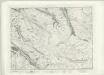
Inverbroom - OS One-Inch map
1 : 63360 Topographic maps Ordnance Survey Ordnance Survey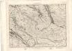
Inverbroom - OS One-Inch map
1 : 63360 Topographic maps Ordnance Survey Ordnance Survey
Ullapool - OS One-Inch Map
1 : 63360 Topographic maps Ordnance Survey Ordnance Survey
Strome Ferry, Gairloch - Bartholomew's 'Survey Atlas of Scotland'
1 : 126720 Topographic maps John Bartholomew & Son, Ltd John Bartholomew & Son, Ltd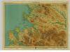
Loch Broom, Sheet 24 - Bartholomew's "Half Inch to the Mile Maps" of Scotland
1 : 126720 Topographic maps John Bartholomew & Son, Ltd John Bartholomew & Son, Ltd
Gair Loch & Loch Inver, Sheet 24 - Bartholomew's "Half Inch to the Mile Maps" of Scotland
1 : 126720 Topographic maps Bartholomew, John George John Bartholomew & Co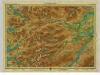
Central Ross, Sheet 20 - Bartholomew's "Half Inch to the Mile Maps" of Scotland
1 : 126720 Topographic maps John Bartholomew & Son, Ltd John Bartholomew & Son, Ltd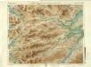
Central Ross & Cromarty, Sheet 20 - Bartholomew's "Half Inch to the Mile Maps" of Scotland
1 : 126720 Topographic maps Bartholomew, John George John Bartholomew & Co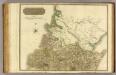
Ross, Cromarty Shires N.
1 : 190000 Craig, John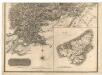
Southern Part of Ross and Cromarty Shires.
Thomson, John, 1777- ca. 1840 Craig, John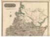
Northern Part of Ross and Cromarty Shires. Southern Part.
Thomson, John, 1777- ca. 1840 Craig, John
Composite: Ross, Cromarty Shires.
1 : 190000 Craig, John
Ardnamurchan to Summer Isles, including the Inner Channel and part of the Minch.
Great Britain. Hydrographic Office
Scotland / J. Ainslie, 2
1 Blatt : 68 x 58 cm Ainslie, Faden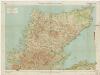
[Kaart], uit: Sutherland & Caithness
1 : 253440 titelvariant: Sutherland and Caithness; Annotatie: Titel op omslag: Sutherland and Caithness; Verso: bladoverzicht reeks Edinburgh : Bartholomew
Scotland[Motoring Map of]
London : "Geographia
Composite: Inverness Shire.
1 : 128000 Johnson, William, fl. 1806-1840
Pascaert vande westkust van Schotlant, als mede een gedeelte van de Lewys Eylanden, van S. Patricius tot Nary, Nog t'I. Roda ofte Barre en t'I. S. Kilda met al Syn diepten en droochten, dus ver naeuke
Keulen, Johannes van, 1654-1715
Ordnance Survey of Great Britain, Scotland
Ordnance Survey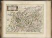
Scotiae provinciae mediterraneae inter Taum flumen et Vararis aestuarium : Sunt autem Braid-Allaban, Atholia, Marria Superior, Badenocha, Strath-Spea, Lochabria, cum Chersoneso qui ei ad occasum pra
Gordon, Robert, 1580-1661 Blaeu, Joan, 1596-1673
Extimae Scotiae pars Septentrionalis, in qua Provinciae Rossia, Sutherlandia, Cathenesia, et Strath-Naverniae. [Karte], in: Novus atlas absolutissimus, Bd. 8, S. 166.
1 Karte aus Atlas Janssonius Offizin
The Shires of Ross, and Cromartie / by Her. Moll.
Moll, Herman, d. 1732
Extima Scotiæ septentrionalis ora
1 Karte : Kupferdruck ; 40 x 50 cm Blaeu; Gordon Joan Blaeu