Maps of Dumfries and Galloway
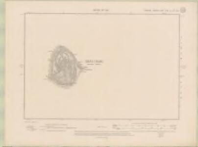
Ayrshire Sheet XLIXa.SW & 55a NW - OS 6 Inch map
1 : 10560 Topographic maps Ordnance Survey Ordnance Survey
Ailsa Craig & Girvan (82) - OS One-Inch map
1 : 63360 Topographic maps Ordnance Survey Ordnance Survey
Ailsa Craig & Girvan (82) - OS One-Inch map
1 : 63360 Topographic maps Ordnance Survey Ordnance Survey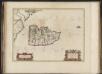
Arania Insula in aestuario Glottae, [vulgo], The Yle of Arren in the Fyrth of Clyd / Timotheo Pont, auctore.
Pont, Timothy, 1560?-1614? Blaeu, Joan, 1596-1673
Arania insula in æstuario Glottæ
1 Karte : Kupferdruck ; 38 x 51 cm Blaeu; Pont Joan Blaeu
Girvan - OS One-Inch Map
1 : 63360 Topographic maps Ordnance Survey Ordnance Survey
Campbeltown - Bartholomew's 'Survey Atlas of Scotland'
1 : 126720 Topographic maps John Bartholomew & Son, Ltd John Bartholomew & Son, Ltd
ARANIA | Insula in æstuario Glottæ | THE YLE OF ARREN | in the Fyrth of Clyd
Timotheo Pont Auctore. [Amsterdam : Joan Blaeu]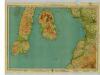
Arran & Lower Clyde, Sheet 3 - Bartholomew's "Half Inch to the Mile Maps" of Scotland
1 : 126720 Topographic maps John Bartholomew & Son, Ltd John Bartholomew & Son, Ltd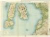
Arran & Lower Clyde, Sheet 3 - Bartholomew's "Half Inch to the Mile Maps" of Scotland
1 : 126720 Topographic maps Bartholomew, John George John Bartholomew & Co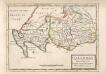
Galloway : Contains The Shires of Wigton and Kirkcudbright / Her. Moll.
Moll, Herman, d. 1732
Gallovidia vernacule Galloway
1 Karte : Kupferdruck ; 40 x 51 cm Blaeu; Pont Joan Blaeu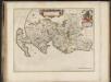
Gallovidia, vernacule Galloway / auct. Timoth. Pont.
Pont, Timothy, 1560?-1614? Blaeu, Joan, 1596-1673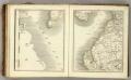
Sheets 64-65. (Cary's England, Wales, and Scotland).
1 : 360000 Cary, John, ca. 1754-1835
Composite: Ayrshire
1 : 78000 Johnson, William, fl. 1806-1840
A mape of the west of Scotland containing Clydsdail, Nithsdail, Ranfrew, Shyre of Ayre, & Galloway / authore Jo. Adair.
Adair, John, ca. 1650-1722
GALLOVIDIA | vernacule | GALLOWAY.
Auct. Timoth: Pont. [Amsterdam : Joan Blaeu]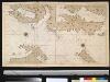
De Noord Oost kust van IJrlandt
Ireland Gerard van Keulen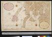
Nieuwe afteekening van de West kust van SchotLand als ook de eijlanden van Jura, Collensa, IJla, Cantijra en Arren
Great-Britain Gerard van Keulen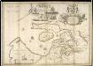
A new and exact map of the River Clyde done by the late Mr. John Adair / now publish'd for the good of the publick by Geo. Scott.
Adair, John, ca. 1650-1722
Scotland[Motoring Map of]
London : "Geographia
Scotland / J. Ainslie, 8
1 Blatt : 68 x 57 cm Ainslie, Faden
Nieuwe Caart van de Rivier van Glasgow in 't Groot.
Keulen, Johannes van, 1654-1715
Belfast
1 : 250000 Belfast (Severní Irsko) War Office
delineation of the strata of England and Wales, with part of Scotland
1 : 320000 Blatt 1 Smith, William Cary
Vltonia; hibernis Cvi-Gvilly; anglis Vlster
1 Karte : Kupferdruck ; 40 x 48 cm Blaeu Joan Blaeu
Carte particuliere de la cote occidentale d'Escosse, depuis la Pointe d'Ardnamurchan jusqu'au Mull de Galloway.
Depot Generale de la Marine, Paris
Lorna, Knapdalia, Cantire, Iura, Ila, Glota, et Buthe Insulae. [Karte], in: Novus atlas absolutissimus, Bd. 8, S. 175.
1 Karte aus Atlas Janssonius Offizin
Scotland SW.
1 : 500000 Cary, John, ca. 1754-1835