Cataloged map
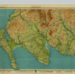
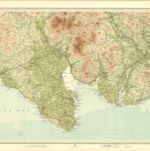
Wigtown - Bartholomew's 'Survey Atlas of Scotland'

Full title:Wigtown - Bartholomew's 'Survey Atlas of Scotland'
Depicted:1912
Pubdate:1912
Publisher:John Bartholomew & Son, Ltd
Physical Size:20 x 30 cm
Map scale:1:126 720
Gallovidia vernacule Galloway
1654
Blaeu; Pont
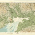
Solway, Sheet 2 - Bartholomew's "Half Inch to the Mile Maps" of Scotland
1929
John Bartholomew & Son, Ltd
1:127k
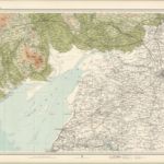
Solway District, Sheet 2 - Bartholomew's "Half Inch to the Mile Maps" of Scotland
1903
Bartholomew, John George
1:127k
Nithia vicecomitatvs
1654
Blaeu; Pont
Galloway, Sheet 1 - Bartholomew's "Half Inch to the Mile Maps" of Scotland
1934
John Bartholomew & Son, Ltd
1:127k
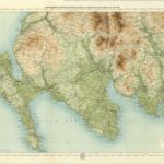
Wigtown, Sheet 1 - Bartholomew's "Half Inch to the Mile Maps" of Scotland
1901
Bartholomew, John George
1:127k
Gallovidiæ pars media, quæ Deam et Cream fluvios interjacet
1654
Blaeu; Pont
Wigtown - Bartholomew's 'Survey Atlas of Scotland'
1912
John Bartholomew & Son, Ltd
1:127k
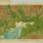
Solway - Bartholomew's 'Survey Atlas of Scotland'
1912
John Bartholomew & Son, Ltd
1:127k
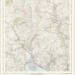
New Galloway - OS One-Inch Map
1951
Ordnance Survey
1:63k