Maps of Scotland
Shetland, Sheet LIV - OS 6 Inch map
1 : 10560 Topographic maps Ordnance Survey Ordnance Survey
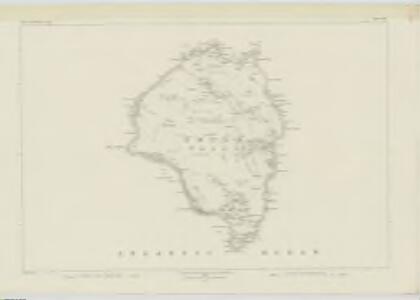
Foula - OS One-Inch map
1 : 63360 Topographic maps Ordnance Survey Ordnance Survey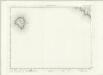
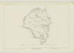
Foula - OS One-Inch map
1 : 63360 Topographic maps Ordnance Survey Ordnance Survey
Foula - OS One-Inch map
1 : 63360 Topographic maps Ordnance Survey Ordnance Survey
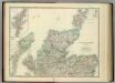
Remote British Isles.
Arrowsmith, Aaron; Lewis, Samuel
Shetland, Southern - Bartholomew's 'Survey Atlas of Scotland'
1 : 126720 Topographic maps John Bartholomew & Son, Ltd John Bartholomew & Son, Ltd
The Shetland Isles.
Great Britain. Hydrographic Office
Het Eyland Hitland met Zyn onderhoorige Eylanden : Wort by de Engelsche Shetland genaamt / by Gerard van Keulen.
Keulen, Gerard van
Carte des Isles Shetland.
Depot Generale de la Marine, Paris
A new hydrographical survey of the islands of Shetland.
Preston, Thomas, fl. 1743-1744
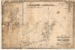
Shetland Islands.
1 : 197000 Thomson, John
Ordnance Survey of Great Britain, Scotland
Ordnance Survey
Orcadum et Schetlandiae Insularum accuratissima descriptio. [Karte, Schetlandia], in: Gerardi Mercatoris et I. Hondii Newer Atlas, oder, Grosses Weltbuch, Bd. 1, S. 69.
1 Karte aus Atlas Mercator, Gerhard und Hondius, Jodocus Jansson, Jan
Museumskart 149: Kaart over de Hetlandske Øer
1 : 100000
Orcadvm et Schetlandiæ insvlarvm accuratissima descriptio
2 Karten auf 1 Blatt : Kupferdruck ; zusammen 37 x 48 cm Valck; Schenk apud G. Valk et P. Schenk
Orcadvm et Schetlandiæ insvlarvm accuratissima descriptio
2 Karten auf 1 Blatt : Kupferdruck ; zusammen 39 x 52 cm Blaeu; Blaeu Joan Blaeu
[Orkney Islands, Shetland Islands.]
Great Britain. Hydrographic Office
Chart of Shetland Isles and Orkney Islands
1 : 15000000 Columbine, Edward Henry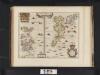
Orcadum et Shetlandiae Insularum accuratissima descriptio.
Blaeu, Willem Janszoon, 1571-1638 Blaeu, Joan, 1596-1673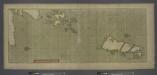
A large draught of the ISLES of ORKNEY with the north part of SCOTLAND
from The sea-atlas : containing an hydrographical description of most of the sea-coasts of the known parts of the world.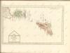
A chart of the north coast of Scotland including the Orkney and Shetland Islands.
Blachford, W.
A general map of Scotland and islands thereto belonging, 2
1 Blatt : 91 x 62 cm s.n.
Les isles Orcadney, ou Orkney; Schetland, ou Hetland; et de Fero, ou Farre
1 Karte : Kupferdruck ; 41 x 52 cm Sanson; Fortin chez le Sr. Fortin ing.r pour les globes rue de la Harpe près celle du Foin
Les isles Orcadney, ou Orkney; Schetland, ou Hetland; et de Fero, ou Farre
1 Karte : Kupferdruck ; 41 x 52 cm Sanson; Mariette chez Pierre Mariette rue St. Iacques a l'Esperance
The East Coast of Scotland with the Isles of Orkney and Shetland.
Collins, Greenvile, fl. 1669-1698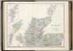
Scotland N.
1 : 633600 Johnston, Alexander Keith, 1804-1871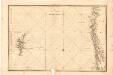
Museumskart 180: Den nordlige delen av Nordsjøen, med Shetland og deler av Norskekysten
1 : 500000 C. Akrel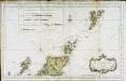
Partie septentrionale de l'Ecosse
1 Karte : Kupferdruck ; 50 x 82 cm s.n.