Maps of Perthshire and Kinross
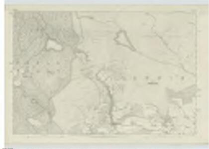
Perthshire, Sheet LI - OS 6 Inch map
1 : 10560 Topographic maps Ordnance Survey Ordnance Survey
Perth and Clackmannan Sheet LI.NE - OS 6 Inch map
1 : 10560 Topographic maps Ordnance Survey Ordnance Survey
Perth and Clackmannan Sheet LI.NW - OS 6 Inch map
1 : 10560 Topographic maps Ordnance Survey Ordnance Survey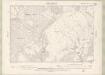
Perth and Clackmannan Sheet LI.SW - OS 6 Inch map
1 : 10560 Topographic maps Ordnance Survey Ordnance Survey
Perth and Clackmannan Sheet LI.SE - OS 6 Inch map
1 : 10560 Topographic maps Ordnance Survey Ordnance Survey
Perth and Clackmannan, Sheet LI.4 (Kinloch) - OS 25 Inch map
1 : 2500 Topographic maps Ordnance Survey Ordnance Survey
Perth and Clackmannan, Sheet LII.5 (with inset LI.12) (Kinloch) - OS 25 Inch map
1 : 2500 Topographic maps Ordnance Survey Ordnance Survey
Perth and Clackmannan, Sheet LI.11 (Clunie) - OS 25 Inch map
1 : 2500 Topographic maps Ordnance Survey Ordnance Survey
Perth and Clackmannan, Sheet LI.11 (Caputh) - OS 25 Inch map
1 : 2500 Topographic maps Ordnance Survey Ordnance Survey
Perth and Clackmannanshire, Sheet 051.11 - 25 Inch Map
1 : 2500 Topographic maps Ordnance Survey Ordnance Survey
Perth and Clackmannan, Sheet LI.15 (Caputh) - OS 25 Inch map
1 : 2500 Topographic maps Ordnance Survey Ordnance Survey
Perth and Clackmannan, Sheet LI.15 (Clunie) - OS 25 Inch map
1 : 2500 Topographic maps Ordnance Survey Ordnance Survey
Perth and Clackmannanshire, Sheet 051.15 - 25 Inch Map
1 : 2500 Topographic maps Ordnance Survey Ordnance Survey
Perth and Clackmannan, Sheet LI.14 (Caputh) - OS 25 Inch map
1 : 2500 Topographic maps Ordnance Survey Ordnance Survey
Perth and Clackmannanshire, Sheet 051.06 - 25 Inch Map
1 : 2500 Topographic maps Ordnance Survey Ordnance Survey
Perth and Clackmannanshire, Sheet 051.14 - 25 Inch Map
1 : 2500 Topographic maps Ordnance Survey Ordnance Survey
Perth and Clackmannanshire, Sheet 051.10 - 25 Inch Map
1 : 2500 Topographic maps Ordnance Survey Ordnance Survey
Perth and Clackmannan, Sheet LI.10 (Caputh) - OS 25 Inch map
1 : 2500 Topographic maps Ordnance Survey Ordnance Survey
Perth and Clackmannan, Sheet LI.13 (with inset LI.9) (Caputh) - OS 25 Inch map
1 : 2500 Topographic maps Ordnance Survey Ordnance Survey
Perth and Clackmannan, Sheet LI.16 (Clunie) - OS 25 Inch map
1 : 2500 Topographic maps Ordnance Survey Ordnance Survey
Perth and Clackmannan, Sheet LII.13 (with inset LXIII.1 & LI.16) (Kinloch & Caputh (Det No6)) - OS 25 Inch map
1 : 2500 Topographic maps Ordnance Survey Ordnance Survey
Perth and Clackmannanshire, Sheet 051.16 - 25 Inch Map
1 : 2500 Topographic maps Ordnance Survey Ordnance Survey
NO04 - OS 1:25,000 Provisional Series Map
1 : 25000 Topographic maps Ordnance Survey Ordnance Survey
Plan of Dunkeld.
Wood, John, ca. 1780-1847
NO05 - OS 1:25,000 Provisional Series Map
1 : 25000 Topographic maps Ordnance Survey Ordnance Survey
Dunkeld & Pitlochry (56) - OS One-Inch map
1 : 63360 Topographic maps Ordnance Survey Ordnance Survey
Dunkeld & Pitlochry (56) - OS One-Inch map
1 : 63360 Topographic maps Ordnance Survey Ordnance Survey
Blairgowrie - OS One-Inch Map
1 : 63360 Topographic maps Ordnance Survey Ordnance Survey
Dunkeld - Bartholomew's 'Survey Atlas of Scotland'
1 : 126720 Topographic maps John Bartholomew & Son, Ltd John Bartholomew & Son, Ltd