Maps of Perthshire and Kinross
Inverness-shire (Mainland), Sheet CXLVI - OS 6 Inch map
1 : 10560 Topographic maps Ordnance Survey Ordnance Survey
Inverness-shire - Mainland Sheet CXLVI - OS 6 Inch map
1 : 10560 Topographic maps Ordnance Survey Ordnance Survey
Perth and Clackmannan Sheet XI.NW - OS 6 Inch map
1 : 10560 Topographic maps Ordnance Survey Ordnance Survey
Perth and Clackmannan Sheet IV.SW - OS 6 Inch map
1 : 10560 Topographic maps Ordnance Survey Ordnance Survey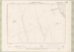
Perth and Clackmannan Sheet XI.NE - OS 6 Inch map
1 : 10560 Topographic maps Ordnance Survey Ordnance Survey
Perth and Clackmannan Sheet IV.SE - OS 6 Inch map
1 : 10560 Topographic maps Ordnance Survey Ordnance Survey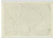
Perthshire, Sheet XI - OS 6 Inch map
1 : 10560 Topographic maps Ordnance Survey Ordnance Survey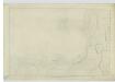
Perthshire, Sheet IV (Inset Sheet I) - OS 6 Inch map
1 : 10560 Topographic maps Ordnance Survey Ordnance Survey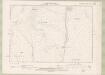
Perth and Clackmannan Sheet X.NE - OS 6 Inch map
1 : 10560 Topographic maps Ordnance Survey Ordnance Survey
Perthshire, Sheet X - OS 6 Inch map
1 : 10560 Topographic maps Ordnance Survey Ordnance Survey
Perth and Clackmannan Sheet III.SE - OS 6 Inch map
1 : 10560 Topographic maps Ordnance Survey Ordnance Survey
Perth and Clackmannan Sheet XI.SW - OS 6 Inch map
1 : 10560 Topographic maps Ordnance Survey Ordnance Survey
Perth and Clackmannan Sheet XI.SE - OS 6 Inch map
1 : 10560 Topographic maps Ordnance Survey Ordnance Survey
Kingussie - OS One-Inch map
1 : 63360 Topographic maps Ordnance Survey Ordnance Survey
Kingussie - OS One-Inch map
1 : 63360 Topographic maps Ordnance Survey Ordnance Survey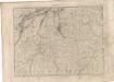
Kingussie - OS One-Inch map
1 : 63360 Topographic maps Ordnance Survey Ordnance Survey
Grampian Mountains & Blair Atholl (49) - OS One-Inch map
1 : 63360 Topographic maps Ordnance Survey Ordnance Survey
Grampian Mountains & Blair Atholl (49) - OS One-Inch map
1 : 63360 Topographic maps Ordnance Survey Ordnance Survey
Kingussie - OS One-Inch Map
1 : 63360 Topographic maps Ordnance Survey Ordnance Survey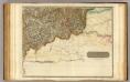
Inverness Shire 7 S.
1 : 128000 Johnson, William, fl. 1806-1840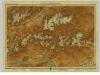
Atholl & Badenoch, Sheet 16 - Bartholomew's "Half Inch to the Mile Maps" of Scotland
1 : 126720 Topographic maps John Bartholomew & Son, Ltd John Bartholomew & Son, Ltd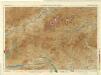
Braemar and Blair Atholl, Sheet 16 - Bartholomew's "Half Inch to the Mile Maps" of Scotland
1 : 126720 Topographic maps Bartholomew, John George John Bartholomew & Co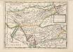
The East Part of the Shire of Inverness with Badenoch &c. / by H. Moll.
Moll, Herman, d. 1732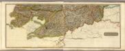
Composite: Inverness Shire S.
1 : 128000 Johnson, William, fl. 1806-1840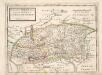
The North P. of Perth Shire containing Athol and Broadalbin / by H. Moll.
Moll, Herman, d. 1732
The counties of Perth and Clackmannan.
Stobie, James, fl. 1775-1804
The counties of Perth and Clackmannan.
Stobie, James, fl. 1775-1804
The counties of Perth and Clackmannan.
Stobie, James, fl. 1775-1804
The counties of Perth and Clackmannan.
Stobie, James, fl. 1775-1804