Maps of Aberdeenshire
Elgin, Sheet V - OS 6 Inch map
1 : 10560 Topographic maps Ordnance Survey Ordnance Survey
Elginshire Sheet V.SW - OS 6 Inch map
1 : 10560 Topographic maps Ordnance Survey Ordnance Survey
Elginshire Sheet V.NE & SE - OS 6 Inch map
1 : 10560 Topographic maps Ordnance Survey Ordnance Survey
Nairnshire Sheet IIa.SE & II.NE - OS 6 Inch map
1 : 10560 Topographic maps Ordnance Survey Ordnance Survey
Elgin, Sheet V.13 (Dyke and Moy) - OS 25 Inch map
1 : 2500 Topographic maps Ordnance Survey Ordnance Survey
Elgin, Sheet V.14 (Dyke and Moy) - OS 25 Inch map
1 : 2500 Topographic maps Ordnance Survey Ordnance Survey
Elgin, Sheet V.10 (with inset V.9) (Dyke and Moy) - OS 25 Inch map
1 : 2500 Topographic maps Ordnance Survey Ordnance Survey
Elginshire, Sheet 005.15 - 25 Inch Map
1 : 2500 Topographic maps Ordnance Survey Ordnance Survey
Elgin, Sheet V.11 (Dyke and Moy) - OS 25 Inch map
1 : 2500 Topographic maps Ordnance Survey Ordnance Survey
Elgin, Sheet V.15 (Dyke and Moy) - OS 25 Inch map
1 : 2500 Topographic maps Ordnance Survey Ordnance Survey
Elgin, Sheet V.12 (Dyke and Moy) - OS 25 Inch map
1 : 2500 Topographic maps Ordnance Survey Ordnance Survey
Elgin, Sheet V.12 (Combined) - OS 25 Inch map
1 : 2500 Topographic maps Ordnance Survey Ordnance Survey
Elgin, Sheet V.8 (Kinloss) - OS 25 Inch map
1 : 2500 Topographic maps Ordnance Survey Ordnance Survey
Elgin, Sheet V.8 (with inset V.7) (Dyke and Moy) - OS 25 Inch map
1 : 2500 Topographic maps Ordnance Survey Ordnance Survey
Elginshire, Sheet 005.16 - 25 Inch Map
1 : 2500 Topographic maps Ordnance Survey Ordnance Survey
Elginshire, Sheet 005.12 - 25 Inch Map
1 : 2500 Topographic maps Ordnance Survey Ordnance Survey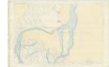
Elgin, Sheet V.16 (Combined) - OS 25 Inch map
1 : 2500 Topographic maps Ordnance Survey Ordnance Survey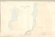
Elgin, Sheet V.16 (with inset V.12) (Forres) - OS 25 Inch map
1 : 2500 Topographic maps Ordnance Survey Ordnance Survey
Nairn, Sheet IIA.14 (with inset IIA.15) (Auldearn) - OS 25 Inch map
1 : 2500 Topographic maps Ordnance Survey Ordnance Survey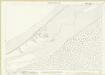
Nairnshire, Sheet 002A.15 - 25 Inch Map
1 : 2500 Topographic maps Ordnance Survey Ordnance Survey
NJ06 & Parts of NH96 - OS 1:25,000 Provisional Series Map
1 : 25000 Topographic maps Ordnance Survey Ordnance Survey
Cromarty - OS One-Inch map
1 : 63360 Topographic maps Ordnance Survey Ordnance Survey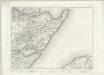
Cromarty - OS One-Inch map
1 : 63360 Topographic maps Ordnance Survey Ordnance Survey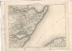
Cromarty - OS One-Inch map
1 : 63360 Topographic maps Ordnance Survey Ordnance Survey
Nairn & Cromarty (28) - OS One-Inch map
1 : 63360 Topographic maps Ordnance Survey Ordnance Survey
Nairn & Cromarty (28) - OS One-Inch map
1 : 63360 Topographic maps Ordnance Survey Ordnance Survey
Elgin - OS One-Inch Map
1 : 63360 Topographic maps Ordnance Survey Ordnance Survey
Nairn and Elgin.
Thomson, John, 1777- ca. 1840 Johnson, William, fl. 1806-1840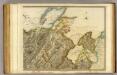
Inverness Shire 5 N.
1 : 128000 Thomson, John