Maps of Moray
Caithness, Sheet XLII - OS 6 Inch map
1 : 10560 Topographic maps Ordnance Survey Ordnance Survey
Caithness-shire Sheet XLII - OS 6 Inch map
1 : 10560 Topographic maps Ordnance Survey Ordnance Survey
Caithness-shire, Sheet 042.11 - 25 Inch Map
1 : 2500 Topographic maps Ordnance Survey Ordnance Survey
Caithness-shire, Sheet 042.08 - 25 Inch Map
1 : 2500 Topographic maps Ordnance Survey Ordnance Survey
Caithness-shire, Sheet 042.12 & 16 - 25 Inch Map
1 : 2500 Topographic maps Ordnance Survey Ordnance Survey
Caithness-shire, Sheet 042.04 - 25 Inch Map
1 : 2500 Topographic maps Ordnance Survey Ordnance Survey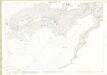
Caithness-shire, Sheet 042.15 - 25 Inch Map
1 : 2500 Topographic maps Ordnance Survey Ordnance Survey
ND12 - OS 1:25,000 Provisional Series Map
1 : 25000 Topographic maps Ordnance Survey Ordnance Survey
Sutherland, Sheet LXVIII - OS 6 Inch map
1 : 10560 Topographic maps Ordnance Survey Ordnance Survey
Sutherland Sheet LXVIII - OS 6 Inch map
1 : 10560 Topographic maps Ordnance Survey Ordnance Survey
Helmsdale (17) - OS One-Inch map
1 : 63360 Topographic maps Ordnance Survey Ordnance Survey
Helmsdale (17) - OS One-Inch map
1 : 63360 Topographic maps Ordnance Survey Ordnance Survey
Wick - OS One-Inch Map
1 : 63360 Topographic maps Ordnance Survey Ordnance Survey
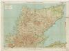
Caithness Shire.
Thomson, John, 1777- ca. 1840 Johnson, William, fl. 1806-1840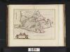
Cathenesia / Auct. Timotheo Pont. Caithness.
Pont, Timothy, 1560?-1614? Blaeu, Joan, 1596-1673
Caithness Shire.
1 : 108000 Thomson, John
Cathenesia
1 Karte : Kupferdruck ; 37 x 51 cm Blaeu; Pont Joan Blaeu
Sovtherlandia
1 Karte : Kupferdruck ; 36 x 51 cm Blaeu Joan Blaeu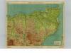
Caithness, Sheet 27 - Bartholomew's "Half Inch to the Mile Maps" of Scotland
1 : 126720 Topographic maps John Bartholomew & Son, Ltd John Bartholomew & Son, Ltd
Caithness District, Sheet 27 - Bartholomew's "Half Inch to the Mile Maps" of Scotland
1 : 126720 Topographic maps Bartholomew, John George John Bartholomew & Co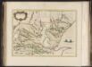
Southerlandia.
Blaeu, Joan, 1596-1673
SOVTHERLANDIA
[Amsterdam : Joan Blaeu]
CATHENESIA. | CAITHNESS.
Auct. | Timotheo Pont. [Amsterdam : Joan Blaeu]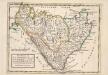
The Shires of Caithness and Sutherland. With Strath Navern which is Part of Sutherland Shire / by H. Moll.
Moll, Herman, d. 1732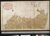
De noordelijkste kust van Schotland met alle desselfs gelegentheden
Scotland Gerard van Keulen
A chart of part of the North of Scotland, from Banff to Duncansby Head.
Ainslie, John, 1745-1828
A chart of part of the North of Scotland, from Banff to Duncansby Head.
Ainslie, John, 1745-1828
A chart of part of the North of Scotland, from Banff to Duncansby Head.
Ainslie, John, 1745-1828
A chart of part of the North of Scotland, from Banff to Duncansby Head.
Ainslie, John, 1745-1828