Maps of Fife
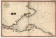
Survey of the Frith [sic] of Forth, by George Thomas... in 1815
Thomas, George, fl. 1809-1846 Great Britain. Hydrographic Office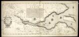
The River and Frith [sic] of Forth ... / Richard Cooper sculpt.
Adair, John, ca. 1650-1722 Cooper, Richard, 1705-1764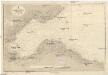
Nordsee
1 : 75000 Severní moře Reichs-Marine-Amt
Edinburgh Firth.
Collins, Greenvile, fl. 1669-1698
FIFÆ | VICECOMITATVS, | The Sherifdome of FYFE.
[Amsterdam : Joan Blaeu]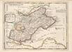
The Shires of Fife and Kinros / by H. Moll.
Moll, Herman, d. 1732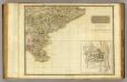
Perthshire SE.
1 : 131000 Storie, James
Fifæ vicecomitatvs
1 Karte : Kupferdruck ; 40 x 51 cm Blaeu Joan Blaeu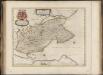
Fifae Vicecomitatus, The Sherifdome of Fyfe.
Gordon, James, 1615?-1686 Blaeu, Joan, 1596-1673
LOTHIAN | and | LINLITQVO
Joh. et Cornelius Blaeu exc.
The Frith of Forth from the Entry to the Queen's ferry, with all the Islands, Rocks, Sands, &c.
Adair, John, ca. 1650-1722
Carte du Golphe d'Edinburgh.
Bellin, J. N.
Ports And Harbours On The East Coast of Scotland.
Fullarton, A. & Co.
The Hydrographicall mappe of Forth from the entry to ye Queens-ferry / authore Jo. Adair.
Adair, John, ca. 1650-1722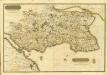
Composite: Fife, Kinross.
1 : 75000 Martin, Alexander
Fife with Kinross Shire.
Thomson, John, 1777- ca. 1840 Johnson, William, fl. 1806-1840
Fife with Kinross Shire.
Thomson, John, 1777- ca. 1840 Johnson, William, fl. 1806-1840
Map of the counties of Fife and Kinross.
Greenwood, Christopher, 1786-1855 Fowler, William, fl. 1818-1863 Sharp, T.
Map of the counties of Fife and Kinross.
Greenwood, Christopher, 1786-1855 Fowler, William, fl. 1818-1863 Sharp, T.
Map of the counties of Fife and Kinross.
Greenwood, Christopher, 1786-1855 Fowler, William, fl. 1818-1863 Sharp, T.
Counties of Fife and Kinross with the Rivers Forth and Tay
Ainslie, John, 1745-1828
Map of the counties of Fife and Kinross.
Greenwood, Christopher, 1786-1855 Fowler, William, fl. 1818-1863 Sharp, T.
Counties of Fife and Kinross with the Rivers Forth and Tay
Ainslie, John, 1745-1828
Counties of Fife and Kinross with the Rivers Forth and Tay
Ainslie, John, 1745-1828
Counties of Fife and Kinross with the Rivers Forth and Tay
Ainslie, John, 1745-1828
Counties of Fife and Kinross with the Rivers Forth and Tay
Ainslie, John, 1745-1828
Counties of Fife and Kinross with the Rivers Forth and Tay
Ainslie, John, 1745-1828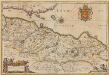
Provincae Lauden seu Lothien et Linlitouo [Karte], in: Novus atlas absolutissimus, Bd. 8, S. 129.
1 Karte aus Atlas Janssonius Offizin
Dunbar, St Andrews, Etc. - Bartholomew's 'Survey Atlas of Scotland'
1 : 126720 Topographic maps John Bartholomew & Son, Ltd John Bartholomew & Son, Ltd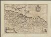
![Survey of the Frith [sic] of Forth, by George Thomas... in 1815](https://images-2.georeferencer.com/images/iiif/182738583542/full/,300/0/native.jpg)

