Maps of West Lothian

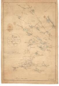
Plan of the crossroads from Linton to Queensferry.
Johnstone, Thomas, ca.1749-1819
Linlithgow Shire.
Forrest, William, fl. 1799-1832
Linlithgow Shire.
Forrest, William, fl. 1799-1832
Mappe of Wast Lothian comonly called Linlithgowshire / authore Johanne Adair.
Adair, John, ca. 1650-1722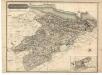
Linlithgowshire.
Thomson, John, 1777- ca. 1840 Johnson, William, fl. 1806-1840
A Map of West Lothian / survey'd by Mr. J. Adair.
Adair, John, ca. 1650-1722 Cooper, Richard, 1705-1764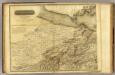
Edinburgh Shire 1 N.
1 : 43000 Knox, James
NT06 - OS 1:25,000 Provisional Series Map
1 : 25000 Topographic maps Ordnance Survey Ordnance Survey
NT16 - OS 1:25,000 Provisional Series Map
1 : 25000 Topographic maps Ordnance Survey Ordnance Survey
NT07 - OS 1:25,000 Provisional Series Map
1 : 25000 Topographic maps Ordnance Survey Ordnance Survey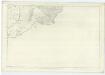
Linlithgowshire, Sheet 7 - OS 6 Inch map
1 : 10560 Topographic maps Ordnance Survey Ordnance Survey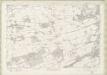
Linlithgowshire Sheet n IX - OS 6 Inch map
1 : 10560 Topographic maps Ordnance Survey Ordnance Survey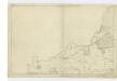
Edinburghshire, Sheet 1 - OS 6 Inch map
1 : 10560 Topographic maps Ordnance Survey Ordnance Survey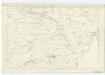
Linlithgowshire, Sheet 6 - OS 6 Inch map
1 : 10560 Topographic maps Ordnance Survey Ordnance Survey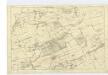
Edinburghshire, Sheet 5 - OS 6 Inch map
1 : 10560 Topographic maps Ordnance Survey Ordnance Survey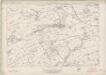
Linlithgowshire Sheet n VIII - OS 6 Inch map
1 : 10560 Topographic maps Ordnance Survey Ordnance Survey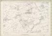
Linlithgowshire Sheet n VIII - OS 6 Inch map
1 : 10560 Topographic maps Ordnance Survey Ordnance Survey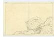
Edinburghshire, Sheet 4 - OS 6 Inch map
1 : 10560 Topographic maps Ordnance Survey Ordnance Survey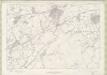
Linlithgowshire Sheet n XII - OS 6 Inch map
1 : 10560 Topographic maps Ordnance Survey Ordnance Survey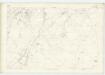
Lanarkshire, Sheet XV (& parts of Edinburghshire sheets X, XI,* - OS 6 Inch map
1 : 10560 Topographic maps Ordnance Survey Ordnance Survey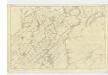
Edinburghshire, Sheet 10 - OS 6 Inch map
1 : 10560 Topographic maps Ordnance Survey Ordnance Survey
Peebles-shire, Sheet I - OS 6 Inch map
1 : 10560 Topographic maps Ordnance Survey Ordnance Survey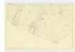
Edinburghshire, Sheet 16 - OS 6 Inch map
1 : 10560 Topographic maps Ordnance Survey Ordnance Survey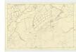
Edinburghshire, Sheet 11 - OS 6 Inch map
1 : 10560 Topographic maps Ordnance Survey Ordnance Survey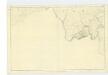
Edinburghshire, Sheet 17 - OS 6 Inch map
1 : 10560 Topographic maps Ordnance Survey Ordnance Survey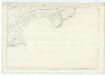
Linlithgowshire, Sheet 10 - OS 6 Inch map
1 : 10560 Topographic maps Ordnance Survey Ordnance Survey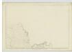
Peebles-shire, Sheet II - OS 6 Inch map
1 : 10560 Topographic maps Ordnance Survey Ordnance Survey
NT17 - OS 1:25,000 Provisional Series Map
1 : 25000 Topographic maps Ordnance Survey Ordnance Survey
NT15 - OS 1:25,000 Provisional Series Map
1 : 25000 Topographic maps Ordnance Survey Ordnance Survey