Maps of Flintshire
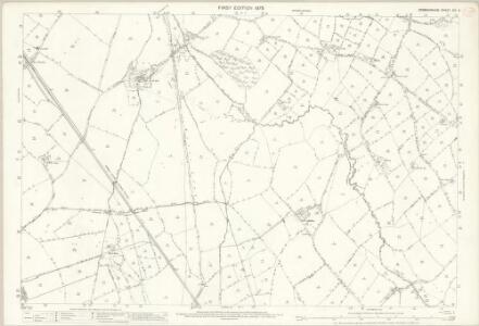
Denbighshire XIX.3 (includes: Llanbedr; Llangynhafal; Llanynys Rural; Rhuthun) - 25 Inch Map
1 : 2500 Topographic maps Ordnance Survey Ordnance Survey
Denbighshire XIX.NE - OS Six-Inch Map
1 : 10560 Topographic maps Ordnance Survey Ordnance Survey
Denbighshire XIX.NE - OS Six-Inch Map
1 : 10560 Topographic maps Ordnance Survey Ordnance Survey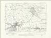
Denbighshire XIX.NE - OS Six-Inch Map
1 : 10560 Topographic maps Ordnance Survey Ordnance Survey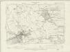
Denbighshire XIX.NE - OS Six-Inch Map
1 : 10560 Topographic maps Ordnance Survey Ordnance Survey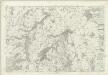
Denbighshire XIX - OS Six-Inch Map
1 : 10560 Topographic maps Ordnance Survey Ordnance Survey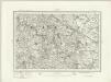
Flint (Outline) - OS One-Inch Revised New Series
1 : 63360 Topographic maps Ordnance Survey Ordnance Survey
Flint (Hills) - OS One-Inch Revised New Series
1 : 63360 Topographic maps Ordnance Survey Ordnance Survey
Ruthin
1 : 31680 This plan covers a section of the Cambrian Mountains from Denbigh in the Vale of Clwyd, at the top, to the valley of the River Dee, which forms a boundary at the bottom right of the map. The drawing is formally titled and the area of the land recorded as 181.1792 square miles. Archaeological sites are named in gothic script. Colour washes depicting relief are combined with numerical annotations of altitude ('spot heights') in black ink. A key to interpreting the mineral content of the landscape survives just below the area calculation table. Entitled 'Mineral Notives', it uses symbols to distinguish limestone, red sandstone, greywacke slate and alluvium. Declivity ('downward tilts') in the land are shown in red by an arrow and angular value. Dawson, Robert
Denbigh - OS One-Inch Map
1 : 63360 Topographic maps Ordnance Survey Ordnance Survey
DENBIGH AC FLINT Sheet 37
This map of Denbigh and Flint is from the 1583 edition of the Saxton atlas of England and Wales.This atlas was first published as a whole in 1579. It consists of 35 coloured maps depicting the counties of England and Wales. The atlas is of great significance to British cartography as it set a standard of cartographic representation in Britain and the maps remained the basis for English county mapping, with few exceptions, until after 1750. During the reign of Elizabeth I map use became more common, with many government matters referring to increasingly accurate maps with consistent scales and symbols, made possible by advances in surveying techniques. Illustrating the increasing used of maps in government matters, Lord Burghley, Elizabeth I’s Secretary of State, who had been determined to have England and Wales mapped in detail from the 1550s, selected the cartographer Christopher Saxton to produce a detailed and consistent survey of the country. The financier of the project was Thomas Seckford Master of Requests at the Court of Elizabeth I, whose arms appear, along with the royal crest, on each map. Saxton, Christopher Ryther, Augustine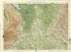
Cheshire, Sheet 12 - Bartholomew's "Half Inch to the Mile Maps" of England & Wales
1 : 126720 Topographic maps Bartholomew, John George John Bartholomew & Co
Denbigiensis comitatus et comitatus Flintensis
1 Karte : Kupferdruck ; 36 x 48 cm Blaeu Joan Blaeu
DENBIGIENSIS | Comitatus et Comitatus | FLINTENSIS; | DENBIGH er FLINTSHIRE.
[Amsterdam : Joan Blaeu]
DENBIGH AC FLINT f.115
This is a map of Denbigh and Flint by Christopher Saxton dating from 1577. It forms part of an atlas that belonged to William Cecil Lord Burghley, Elizabeth I’s Secretary of State. Burghley used this atlas to illustrate domestic matters. This map is actually a proof copy of one which forms part of Christopher Saxton’s Atlas of England and Wales. This atlas was first published as a whole in 1579. It consists of 35 coloured maps depicting the counties of England and Wales. The atlas is of great significance to British cartography as it set a standard of cartographic representation in Britain and the maps remained the basis for English county mapping, with few exceptions, until after 1750. During the reign of Elizabeth I, map use became more common, with many government matters referring to increasingly accurate maps with consistent scales and symbols, made possible by advances in surveying techniques. Illustrating the increasing use of maps in government matters, Lord Burghley, who had been determined to have England and Wales mapped in detail from the 1550s, selected the cartographer Christopher Saxton to produce a detailed and consistent survey of the country. The financier of the project was Thomas Seckford, Master of Requests at the Court of Elizabeth I, whose arms appear, along with the royal crest, on each map. Burghley has annotated this map, adding place names to the map and notes about the shire towns of Denbigh in the margins. At the time England was under threat of invasion from Catholic Spain, a threat which culminated in the events of the Spanish Armada. Defence of the realm depended on a good geographic and topographic knowledge, explaining Burghley's use of maps and his annotation of them, particularly at locations along the coast. The map was engraved by Remigius Hogenbergius, one of a team of seven English and Flemish engravers employed to produce the copper plates for the atlas. Saxton, Christopher William Cecil, Lord Burghley
CESTRIAE Comitatus
This map of Cheshire is by Christopher Saxton dating from 1577. It forms part of an atlas that belonged to William Cecil Lord Burghley, Elizabeth I’s Secretary of State. Burghley used this atlas to illustrate domestic matters. This map is actually a proof copy of one which forms part of Christopher Saxton’s Atlas of England and Wales. This atlas was first published as a whole in 1579. It consists of 35 coloured maps depicting the counties of England and Wales. The atlas is of great significance to British cartography as it set a standard of cartographic representation in Britain and the maps remained the basis for English county mapping, with few exceptions, until after 1750. During the reign of Elizabeth I, map use became more common, with many government matters referring to increasingly accurate maps with consistent scales and symbols, made possible by advances in surveying techniques. Illustrating the increasing use of maps in government matters, Lord Burghley, who had been determined to have England and Wales mapped in detail from the 1550s, selected the cartographer Christopher Saxton to produce a detailed and consistent survey of the country. The financier of the project was Thomas Seckford Master of Requests at the Court of Elizabeth I, whose arms appear, along with the royal crest, on each map.Here Burghley's annotations can be seen in the addition of place names, most densely around Liverpool Haven. Due to the coastal nature of the area it is possible that more information has been added as Burghley was concerned about the possibility of enemy landings in the area. This consideration must be seen in the context of the invasion threat from Spain which culminated in the events of the Spanish Armada in 1588. The map was engraved by Franciscus Scatterus, one of a team of English and Flemish engravers who worked on the atlas. Saxton, Christopher Scatterus, Franciscus
Comitatus Palatinus Cestriae
This is a map of Cheshire by William Smith. It dates from 1585. William Smith was Rouge Dragon at the College of Heralds/College of Arms, an institution that specialised in genealogical work, increasingly more so during the Elizabethan age as the gentry class rose in importance. The Rouge Dragon is the name of one of the Pursuivants, a heraldic officer attendant on the heralds, often attached to a particular nobleman, named so because of their badges. The prominent coat of arms on this plan reveals Smiths heraldic interests. In 1588 Smith completed "The Particuler Description of England. With the portratures of certaine of the cheiffest citties & townes". This work consisted of drawings of English cities and towns in a traditional bird's eye view style, drawings amalgamating bird's eye and plan. In the years 1602-03, William Smith anonymously published maps of Chester, Essex, Hertfordshire Lancashire, Leicester, Norfolk, Northamptonshire, Staffordshire, Suffolk, Surrey, Warwickshire and Worcestershire. These were probably engraved in Amsterdam and were intended to form sheets of a new atlas. After the publication of Saxton’s county maps in the 1570s, cartographers attempted to improve on Saxton’s atlas and replicate its success. Unfortunately for Smith, another cartographer, John Speed, was also preparing county maps at this time and competition proved too great, Speed being the victor. Smith, William
CESTRIAE
This map of Cheshire is from the 1583 edition of the Saxton atlas of England and Wales.This atlas was first published as a whole in 1579. It consists of 35 coloured maps depicting the counties of England and Wales. The atlas is of great significance to British cartography as it set a standard of cartographic representation in Britain and the maps remained the basis for English county mapping, with few exceptions, until after 1750. During the reign of Elizabeth I map use became more common, with many government matters referring to increasingly accurate maps with consistent scales and symbols, made possible by advances in surveying techniques. Illustrating the increasing used of maps in government matters, Lord Burghley, Elizabeth I’s Secretary of State, who had been determined to have England and Wales mapped in detail from the 1550s, selected the cartographer Christopher Saxton to produce a detailed and consistent survey of the country. The financier of the project was Thomas Seckford Master of Requests at the Court of Elizabeth I, whose arms appear, along with the royal crest, on each map. Saxton, Christopher Ryther, Augustine
Cestria Comitatus Palatinus. [Karte], in: Theatrum orbis terrarum, sive, Atlas novus, Bd. 4, S. 381.
1 Karte aus Atlas Blaeu, Joan Blaeu, Willem Janszoon
Cestria Comitatus Palatinus. [Karte], in: Theatrum orbis terrarum, sive, Atlas novus, Bd. 4, S. 381.
1 Karte aus Atlas Blaeu, Joan Blaeu, Willem Janszoon
Cestria Comitatus Palatinus. [Karte], in: Le théâtre du monde, ou, Nouvel atlas contenant les chartes et descriptions de tous les païs de la terre, Bd. 4, S. 329.
1 Karte aus Atlas Blaeu, Willem Janszoon und Blaeu, Joan Blaeu, Willem Janszoon
Sheets 40-41. (Cary's England, Wales, and Scotland).
1 : 360000 Cary, John, ca. 1754-1835
Denbigiensis Comitatus et Comitatus Flintensis; Denbigh et Flintshire. [Karte], in: Le théâtre du monde, ou, Nouvel atlas contenant les chartes et descriptions de tous les païs de la terre, Bd. 4, S. 374.
1 Karte aus Atlas Blaeu, Willem Janszoon und Blaeu, Joan Blaeu, Willem Janszoon
The Countye Palatine Of Chester Comitatus Cestrensis. [Karte], in: Gerardi Mercatoris et I. Hondii Newer Atlas, oder, Grosses Weltbuch, Bd. 1, S. 81.
1 Karte aus Atlas Mercator, Gerhard und Hondius, Jodocus Jansson, Jan
Cestria Comitatus Palantinus. The Countye Palatine of Chester. [Karte], in: Novus atlas absolutissimus, Bd. 7, S. 364.
1 Karte aus Atlas Janssonius Offizin
Denbigiensis Comitatus et Comitatus Flintensis; Denbigh et Flintshire. [Karte], in: Theatrum orbis terrarum, sive, Atlas novus, Bd. 4, S. 434.
1 Karte aus Atlas Blaeu, Joan Blaeu, Willem Janszoon
Denbigiensis Comitatus et Comitatus Flintensis; Denbigh et Flintshire. [Karte], in: Theatrum orbis terrarum, sive, Atlas novus, Bd. 4, S. 434.
1 Karte aus Atlas Blaeu, Joan Blaeu, Willem Janszoon
MONE INSULAE modo Anglesey et Caernaruan
This is a map of Anglesey and Caernarvon by Christopher Saxton dating from 1578. It forms part of an atlas that belonged to William Cecil Lord Burghley, Elizabeth I’s Secretary of State. Burghley used this atlas to illustrate domestic matters. This map is actually a proof copy of one which forms part of Christopher Saxton’s Atlas of England and Wales. This atlas was first published as a whole in 1579. It consists of 35 coloured maps depicting the counties of England and Wales. The atlas is of great significance to British cartography as it set a standard of cartographic representation in Britain and the maps remained the basis for English county mapping, with few exceptions, until after 1750. During the reign of Elizabeth I, map use became more common, with many government matters referring to increasingly accurate maps with consistent scales and symbols, made possible by advances in surveying techniques. Illustrating the increasing use of maps in government matters, Lord Burghley, who had been determined to have England and Wales mapped in detail from the 1550s, selected the cartographer Christopher Saxton to produce a detailed and consistent survey of the country. The financier of the project was Thomas Seckford, Master of Requests at the Court of Elizabeth I, whose arms appear, along with the royal crest, on each map. Burghley has annotated this map, adding place names to the map and notes about the shire towns of Denbigh in the margins. At this time England was under threat of invasion from Catholic Spain, a threat which culminated in the events of the Spanish Armada. Defence of the realm depended on a good geographic and topographic knowledge, explaining Burghley's use of maps and his annotation of them, particularly at locations along the coast. The map was engraved by one of a team of seven English and Flemish engravers employed to produce the copper plates for the atlas, although the individual name is not recorded. Saxton, Christopher Hogenbergius, Remigius
MONE INSULAE
This map of the isle of Man is from the 1583 edition of the Saxton atlas of England and Wales.This atlas was first published as a whole in 1579. It consists of 35 coloured maps depicting the counties of England and Wales. The atlas is of great significance to British cartography as it set a standard of cartographic representation in Britain and the maps remained the basis for English county mapping, with few exceptions, until after 1750. During the reign of Elizabeth I map use became more common, with many government matters referring to increasingly accurate maps with consistent scales and symbols, made possible by advances in surveying techniques. Illustrating the increasing used of maps in government matters, Lord Burghley, Elizabeth I’s Secretary of State, who had been determined to have England and Wales mapped in detail from the 1550s, selected the cartographer Christopher Saxton to produce a detailed and consistent survey of the country. The financier of the project was Thomas Seckford Master of Requests at the Court of Elizabeth I, whose arms appear, along with the royal crest, on each map. Saxton, Christopher Ryther, Augustine