Maps of Powys
Montgomeryshire XXII.9 (includes: Llanfair Caereinion) - 25 Inch Map
1 : 2500 Topographic maps Ordnance Survey Ordnance Survey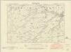
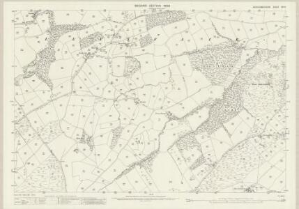
Montgomeryshire XXII.SW - OS Six-Inch Map
1 : 10560 Topographic maps Ordnance Survey Ordnance Survey
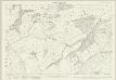
Montgomeryshire XXII.SW - OS Six-Inch Map
1 : 10560 Topographic maps Ordnance Survey Ordnance Survey
Montgomeryshire XXII.SW - OS Six-Inch Map
1 : 10560 Topographic maps Ordnance Survey Ordnance Survey
SJ00 - OS 1:25,000 Provisional Series Map
1 : 25000 Topographic maps Ordnance Survey Ordnance Survey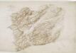
Meifod
1 : 31680 A triangulation diagram appears on the reverse of this drawing. This allowed draughtsmen to plot the exact location of prominent features of the landscape. Archaeological sites are named in gothic script.Black ink numbers indicate the heights of the hills. Still, Henry
Dinas-Mawddwy (Hills) - OS One-Inch Revised New Series
1 : 63360 Topographic maps Ordnance Survey Ordnance Survey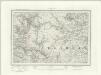
Dinas-Mawddwy (Outline) - OS One-Inch Revised New Series
1 : 63360 Topographic maps Ordnance Survey Ordnance Survey
Llanerfyl
1 : 31680 The formal title of the drawing states that Robert Dawson supervised the surveyor. Dawson, one of the best surveyors and draughtsmen, was employed on the Ordnance Survey for over forty years, working also as an instructor. The scale of the drawing is noted and the area of the land recorded as 165.4742 square miles. A triangulation diagram appears on the reverse. This enabled draughtsmen to plot the exact location of topographical features. Colour washes depicting relief are combined with numerical annotations ('spot heights') in black ink indicating the heights of hills. The draughtsman has also distinguished between the representation of coniferous and deciduous trees. Hall, Joseph
Newtown
1 : 31680 The River Severn Valley,features,runs,from left to right on this plan of part of mid- Wales. With its source high on the Cumbrian Mountains, the river flows through,a narrow rocky channel in its upper course, becoming wider and deeper in its middle course and its valley flatter. Budgen, Thomas
Bala and Welshpool - OS One-Inch Map
1 : 63360 Topographic maps Ordnance Survey Ordnance Survey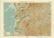
Aberystwyth, Sheet 16 - Bartholomew's "Half Inch to the Mile Maps" of England & Wales
1 : 126720 Topographic maps Bartholomew, John George John Bartholomew & Co
Montgomeria comitatus et comitatus Mervinia
1 Karte : Kupferdruck ; 37 x 48 cm Blaeu Joan Blaeu
MONTGOMERIA | Comitatus et Comitatus | MERVINIA.
[Amsterdam : Joan Blaeu]
MONTGOMERI
This map of Montgomery is from the 1583 edition of the Saxton atlas of England and Wales.This atlas was first published as a whole in 1579. It consists of 35 coloured maps depicting the counties of England and Wales. The atlas is of great significance to British cartography as it set a standard of cartographic representation in Britain and the maps remained the basis for English county mapping, with few exceptions, until after 1750. During the reign of Elizabeth I map use became more common, with many government matters referring to increasingly accurate maps with consistent scales and symbols, made possible by advances in surveying techniques. Illustrating the increasing used of maps in government matters, Lord Burghley, Elizabeth I’s Secretary of State, who had been determined to have England and Wales mapped in detail from the 1550s, selected the cartographer Christopher Saxton to produce a detailed and consistent survey of the country. The financier of the project was Thomas Seckford Master of Requests at the Court of Elizabeth I, whose arms appear, along with the royal crest, on each map. Saxton, Christopher Ryther, Augustine
Ceretica, sive Cardiganensis Comitatus, anglis Cardigan Shire
1 : 460000 Amstelodami : apud Joannem Janssonium
Mervinia, et Montgomeria Comitatus
1 : 230000 [Amstelodami] : [apud Joannem Janssonium]
South Wales and the border in the 14th century
Rees, William Ordnance Survey
CERETICA; | sive | CARDIGANensis | Comitatus; Anglis | CARDIGAN SHIRE.
[Amsterdam : Joan Blaeu]
MONE INSULAE
This map of the isle of Man is from the 1583 edition of the Saxton atlas of England and Wales.This atlas was first published as a whole in 1579. It consists of 35 coloured maps depicting the counties of England and Wales. The atlas is of great significance to British cartography as it set a standard of cartographic representation in Britain and the maps remained the basis for English county mapping, with few exceptions, until after 1750. During the reign of Elizabeth I map use became more common, with many government matters referring to increasingly accurate maps with consistent scales and symbols, made possible by advances in surveying techniques. Illustrating the increasing used of maps in government matters, Lord Burghley, Elizabeth I’s Secretary of State, who had been determined to have England and Wales mapped in detail from the 1550s, selected the cartographer Christopher Saxton to produce a detailed and consistent survey of the country. The financier of the project was Thomas Seckford Master of Requests at the Court of Elizabeth I, whose arms appear, along with the royal crest, on each map. Saxton, Christopher Ryther, Augustine
Ceretica; sive Cardiganensis Comitatus; Anglis Cardigan Shire. [Karte], in: Theatrum orbis terrarum, sive, Atlas novus, Bd. 4, S. 421.
1 Karte aus Atlas Blaeu, Joan Blaeu, Willem Janszoon
Ceretica; sive Cardiganensis Comitatus; Anglis Cardigan Shire. [Karte], in: Theatrum orbis terrarum, sive, Atlas novus, Bd. 4, S. 421.
1 Karte aus Atlas Blaeu, Joan Blaeu, Willem Janszoon
Montgomeria Comitatus et Comitatus Mervinia. [Karte], in: Le théâtre du monde, ou, Nouvel atlas contenant les chartes et descriptions de tous les païs de la terre, Bd. 4, S. 366.
1 Karte aus Atlas Blaeu, Willem Janszoon und Blaeu, Joan Blaeu, Willem Janszoon
Montgomeria Comitatus et Comitatus Mervinia. [Karte], in: Theatrum orbis terrarum, sive, Atlas novus, Bd. 4, S. 424.
1 Karte aus Atlas Blaeu, Joan Blaeu, Willem Janszoon
Ceretica; sive Cardiganensis Comitatus; Anglis Cardigan Shire. [Karte], in: Novus atlas absolutissimus, Bd. 7, S. 395.
1 Karte aus Atlas Janssonius Offizin
COMITATVS | SALOPIENSIS; | Anglice | SHROP SHIRE.
[Amsterdam : Joan Blaeu]
SALOPIAE COMITATUS f.86
This is a map of Shropshire by Christopher Saxton dating from 1577. It forms part of an atlas that belonged to William Cecil Lord Burghley, Elizabeth I’s Secretary of State. Burghley used this atlas to illustrate domestic matters. This map is actually a proof copy of one which forms part of Christopher Saxton’s Atlas of England and Wales. This atlas was first published as a whole in 1579. It consists of 35 coloured maps depicting the counties of England and Wales. The atlas is of great significance to British cartography as it set a standard of cartographic representation in Britain and the maps remained the basis for English county mapping, with few exceptions, until after 1750. During the reign of Elizabeth I, map use became more common, with many government matters referring to increasingly accurate maps with consistent scales and symbols, made possible by advances in surveying techniques. Illustrating the increasing use of maps in government matters, Lord Burghley, who had been determined to have England and Wales mapped in detail from the 1550s, selected the cartographer Christopher Saxton to produce a detailed and consistent survey of the country. The financier of the project was Thomas Seckford Master of Requests at the Court of Elizabeth I, whose arms appear, along with the royal crest, on each map. Burghley has annotated this map, adding several place names. The map was engraved by Remigius Hogenbergius, one of a team of seven English and Flemish engravers employed to produced the copper plates for the atlas. Saxton, Christopher Hogenbergius, Remigius
Mervinia; et Montgomeria Comitatus. [Karte], in: Novus atlas absolutissimus, Bd. 8, S. 11.
1 Karte aus Atlas Janssonius Offizin
Montgomeria Comitatus et Comitatus Mervinia. [Karte], in: Theatrum orbis terrarum, sive, Atlas novus, Bd. 4, S. 424.
1 Karte aus Atlas Blaeu, Joan Blaeu, Willem Janszoon