Maps of Sunderland
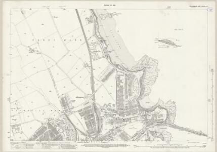
Northumberland (New Series) LXXXVII.13 & 14 (includes: Tynemouth) - 25 Inch Map
1 : 2500 Topographic maps Ordnance Survey Ordnance Survey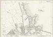
Northumberland (New Series) LXXXVII.14 (inset LXXXVII.13) (includes: Tynemouth) - 25 Inch Map
1 : 2500 Topographic maps Ordnance Survey Ordnance Survey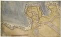
Tynemouth
This is a plan of fortifications at Tynemouth. It shows the internal structures of the fort, noting the function of each; stables, constable’s lodgings and gate house are marked. The town itself is shown in relation to the fort as a generic group of buildings, revealing that the defence fortifications are the primary concern of the draughtsman. This plan dates from 1580’s, a time of unease in England about the possibility of a Spanish invasion. The Anglo-Spanish relationship had been in steady decline since the accession of the protestant Elizabeth I. Raids on transatlantic shipping by English seamen such as Francis Drake and England’s support of the Protestant rebellion in the Spanish ruled Netherlands made matters worse and war broke out in 1585, culminating in the events of the Spanish Armada. It is recorded that on 18th March 1588, Lord Hunsdon, Governor at Berwick, informed Sir Francis Walsingham that in response to the Council’s worries about the decay of Tynemouth, he would go there with his surveyor of works, a very skilful man’ and take a perfect view’, which he would then bring to London. This plan may be the referred to perfect view’, reflecting the concern over Tynemouth’s defences in the face of the impending Spanish invasion. This plan is also interesting as it does not show two Italianate demi bastions. These were proposed to be built in plans dating from 1545. Their absence here compounds the documentary evidence that suggests that they were never built.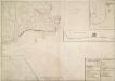
A Plan of Tinmouth Town and Castle and Clifford Fort, scituate at the Entrance of the River Tine
View of Tynemouth Castle, town and Clifford Fort with a separate small plan of Clifford Fort and section of the same fort. Tynemouth castle is situated on the cliff overlooking the River Tyne. The stone Barbican was built in the 14th century but there has been a castle on this site since the 11th century as there are records dating from 1095 detailing William Rufus’ successful capture of Earl Robert’s castle. Inside the Castle complex is Tynemouth Priory- this was once the richest priory in England and it has an impressive 22 meter high presbytery. By the 17th century the castle was a ruin and defence of the river was taken over by Clifford Fort at North Shield, which was built in 1672. The fort was built to protect the entrance to the River Tyne during the 3rd Dutch War. It was designed by a Swedish military engineer, Martin Beckman, and built by a Yorkshire architect, Robert Trollope.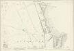
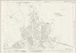
Northumberland (Old Series) LXXXIX.8 (includes: Tynemouth; Whitley And Monkseaton) - 25 Inch Map
1 : 2500 Topographic maps Ordnance Survey Ordnance Survey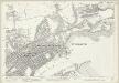
Northumberland (Old Series) LXXXIX.12 (includes: South Shields; Tynemouth) - 25 Inch Map
1 : 2500 Topographic maps Ordnance Survey Ordnance Survey
A Coloured Plan of Tynemouth Abbey and Castle
This is a map of Tynemouth dating from 1545. On the basis of handwriting it is thought that the cartographer was Gian Tommaso Scala, described, with Antonio da Bergamo, as 'Italians expert in fortifying' and employed by Henry VIII in the 1540’s as engineers. Tynemouth was reviewed by Sir Richard Lee in February 1545. He found it to be 'a place moste apte and nedeful to be fortyfied' 'none within this realme more'. Hostilities between England and France broke out once again in 1542 and Henry VIII was concerned about possible French plans to attack via the North as well as from Scotland. Reflecting this concern Lee was sent to survey the area with Gian Tommaso Scala and Antonio da Bergamo. This drawing and the proposals it contains may be the result of this survey. It shows two Italianate demi-bastions. These are very large and were intended to house artillery and reinforce the curtain wall which defended the west, landward, side. These proposals show the transmission of the Italian trace italienne fortification to the English. Quadrilinear in overall layout with massive angle-bastions the trace Italian fortification provided fire power outwards and flanking power along the walls so that no blind spots existed, enabling defenders to cover all the surrounding ground. Nothing like Scala’s proposal was built as there was not sufficient time to undertake anything so complex. A large ditch and a very long earth wall were built instead. Scala, Gian Tommaso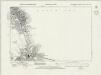
Northumberland nLXXXVII.SW - OS Six-Inch Map
1 : 10560 Topographic maps Ordnance Survey Ordnance Survey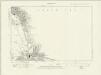
Northumberland nLXXXVII.SW - OS Six-Inch Map
1 : 10560 Topographic maps Ordnance Survey Ordnance Survey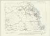
Northumberland LXXXIX.NE - OS Six-Inch Map
1 : 10560 Topographic maps Ordnance Survey Ordnance Survey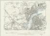
Northumberland LXXXIX.SE - OS Six-Inch Map
1 : 10560 Topographic maps Ordnance Survey Ordnance Survey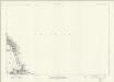
Northumberland nLXXXVII - OS Six-Inch Map
1 : 10560 Topographic maps Ordnance Survey Ordnance Survey
The Course of River Tyne from Newcastle to Tynemouth
This is a detailed map of the course of the River Tyne from Newcastle to the mouth of Tynemouth River, it dates from around 1590. On the basis of style it can be attributed to Richard Poulter, a mariner accomplished in chart making. It is possible that Poulter’s name and the cartouche have been lost when the map was cropped. The map shows the sandbanks and sounding at low tide and notes the need for beacons to be placed on rocks which are submerged at high tide. Water depths at high tide are also indicated. The intersecting lines which cover the map are lines of constant bearing known as rhumb lines. These radiate from compass roses and allow the sailor to plot a course from harbour to harbour using dividers and straight edge. It is likely that this chart was prepared for presentation to a government official who would have power to implement the changes suggested. A possible recipient could be Lord Burghley, Elizabeth Secretary of State. Poulter, Richard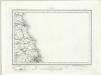
Tynemouth (Outline) - OS One-Inch Revised New Series
1 : 63360 Topographic maps Ordnance Survey Ordnance Survey
Tynemouth (Hills) - OS One-Inch Revised New Series
1 : 63360 Topographic maps Ordnance Survey Ordnance Survey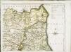
The county palatine of Durham, 2
1 Blatt : 53 x 71 cm R. Sayer & T. Jefferys
Newcastle Upon Tyne - OS One-Inch Map
1 : 63360 Topographic maps Ordnance Survey Ordnance Survey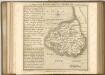

An accurate map of the county palatine of Durham
1 Karte : Kupferdruck ; 50 x 66 cm Kitchin; Hinton printed for J. Hinton at the Kings Arms in St. Pauls Church Yard
DUNELMIENSIS Episcopatus f.68
This is a map of County Durham by Christopher Saxton dating from 1577. It forms part of an atlas that belonged to William Cecil Lord Burghley, Elizabeth I’s Secretary of State. Burghley used this atlas to illustrate domestic matters. This map is actually a proof copy of one which forms part of Christopher Saxton’s Atlas of England and Wales. This atlas was first published as a whole in 1579. It consists of 35 coloured maps depicting the counties of England and Wales. The atlas is of great significance to British cartography as it set a standard of cartographic representation in Britain and the maps remained the basis for English county mapping, with few exceptions, until after 1750. During the reign of Elizabeth I, map use became more common, with many government matters referring to increasingly accurate maps with consistent scales and symbols, made possible by advances in surveying techniques. Illustrating the increasing use of maps in government matters, Lord Burghley, who had been determined to have England and Wales mapped in detail from the 1550s, selected the cartographer Christopher Saxton to produce a detailed and consistent survey of the country. The financier of the project was Thomas Seckford, Master of Requests at the Court of Elizabeth I, whose arms appear, along with the royal crest, on each map. Burghley has annotated this map, adding several place names. The map was engraved by Augustinus Ryther, the most accomplished member of a team of seven English and Flemish engravers employed to produce the copper plates for the atlas. Saxton, Christopher Ryther, Augustinus
Northumberland, South, Sheet 2 - Bartholomew's "Half Inch to the Mile Maps" of England & Wales
1 : 126720 Topographic maps Bartholomew, John George John Bartholomew & Co
County Durham
This is a manuscript map of County Durham. It forms part of an atlas that belonged to William Cecil Lord Burghley, Elizabeth I’s Secretary of State. Burghley used this atlas to illustrate domestic matters. The map dates from 1569 and is by John Rudd, the man to whom Christopher Saxton was an apprentice to in 1570. John Rudd was Vicar of Dewsbury from 1554 to 1570. Rudd had a keen interest in cartography and had been engaged in the 1550s in making a "platt" of England. In 1561 Rudd was granted leave to travel further to map the country and it is likely that Saxton accompanied him, acquiring his skills for surveying. This map is contemporary with the uprising of the northern peers in defence of Mary Queen of Scotts. A dotted line inserted on the map between the end of one river tributary and the start of another neatly illustrates how they were used as communication routes, the fastest way to transport men and arms. Knowledge of breaks in this route system was essential. Rudd, John William Cecil, Lord Burghley
Episcopatvs Dvnelmensis vulgo the bishoprike of Dvrham
1 Karte : Kupferdruck ; 36 x 48 cm Blaeu Joan Blaeu
DUNELMIENSIS Episcopatus Sheet 29
This map ofCounty Durham is from the 1583 edition of the Saxton atlas of England and Wales.This atlas was first published as a whole in 1579. It consists of 35 coloured maps depicting the counties of England and Wales. The atlas is of great significance to British cartography as it set a standard of cartographic representation in Britain and the maps remained the basis for English county mapping, with few exceptions, until after 1750. During the reign of Elizabeth I map use became more common, with many government matters referring to increasingly accurate maps with consistent scales and symbols, made possible by advances in surveying techniques. Illustrating the increasing used of maps in government matters, Lord Burghley, Elizabeth I’s Secretary of State, who had been determined to have England and Wales mapped in detail from the 1550s, selected the cartographer Christopher Saxton to produce a detailed and consistent survey of the country. The financier of the project was Thomas Seckford Master of Requests at the Court of Elizabeth I, whose arms appear, along with the royal crest, on each map. Saxton, Christopher Ryther, Augustine
EPISCOPATVS | DVNELMENSIS. | Vulgo | The Bishoprike of | DVRHAM.
[Amsterdam : Joan Blaeu]
Episcopatus Dunelmensis vulgo the Bishoprike of Durham
1 : 200000 Amstelodami : apud Joannem Janssonium
Episcopatus Dunelmensis, Vulgo The Bishoprike of Durham. [Karte], in: Theatrum orbis terrarum, sive, Atlas novus, Bd. 4, S. 469.
1 Karte aus Atlas Blaeu, Joan Blaeu, Willem Janszoon
Episcopatus Dunelmensis. Vulgo The Bishoprike of Durham. [Karte], in: Le théâtre du monde, ou, Nouvel atlas contenant les chartes et descriptions de tous les païs de la terre, Bd. 4, S. 403.
1 Karte aus Atlas Blaeu, Willem Janszoon und Blaeu, Joan Blaeu, Willem Janszoon
Episcopatus Dunelmensis, Vulgo The Bishoprike of Durham. [Karte], in: Theatrum orbis terrarum, sive, Atlas novus, Bd. 4, S. 469.
1 Karte aus Atlas Blaeu, Joan Blaeu, Willem Janszoon