Maps of Worcestershire
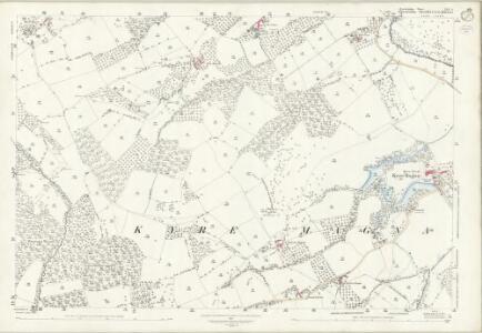
Herefordshire XIII.4 (includes: Bockleton; Kyre; Stoke Bliss; Tenbury) - 25 Inch Map
1 : 2500 Topographic maps Ordnance Survey Ordnance Survey
Worcestershire XIX.14 (includes: Bockleton; Kyre; Stoke Bliss; Tenbury) - 25 Inch Map
1 : 2500 Topographic maps Ordnance Survey Ordnance Survey
Worcestershire XIX.14 (includes: Bockleton; Kyre; Stoke Bliss; Tenbury) - 25 Inch Map
1 : 2500 Topographic maps Ordnance Survey Ordnance Survey
Herefordshire XIII.NE - OS Six-Inch Map
1 : 10560 Topographic maps Ordnance Survey Ordnance Survey
Herefordshire XIII.NE - OS Six-Inch Map
1 : 10560 Topographic maps Ordnance Survey Ordnance Survey
Herefordshire XIII.NE - OS Six-Inch Map
1 : 10560 Topographic maps Ordnance Survey Ordnance Survey
Worcestershire XIX.SW - OS Six-Inch Map
1 : 10560 Topographic maps Ordnance Survey Ordnance Survey
Worcestershire XIX.SW - OS Six-Inch Map
1 : 10560 Topographic maps Ordnance Survey Ordnance Survey
Worcestershire XIX.SW - OS Six-Inch Map
1 : 10560 Topographic maps Ordnance Survey Ordnance Survey
Worcestershire XIX.13 (includes: Bockleton; Kyre; Laysters; Tenbury) - 25 Inch Map
1 : 2500 Topographic maps Ordnance Survey Ordnance Survey
Worcestershire XIX.13 (includes: Bockleton; Kyre; Laysters; Tenbury) - 25 Inch Map
1 : 2500 Topographic maps Ordnance Survey Ordnance Survey
Worcestershire XXVI.2 (includes: Bockleton; Hampton Charles; Kyre; Stoke Bliss; Thornbury) - 25 Inch Map
1 : 2500 Topographic maps Ordnance Survey Ordnance Survey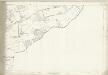
Worcestershire XXVI.2 (includes: Bockleton; Hampton Charles; Kyre; Stoke Bliss; Thornbury) - 25 Inch Map
1 : 2500 Topographic maps Ordnance Survey Ordnance Survey
SO66 - OS 1:25,000 Provisional Series Map
1 : 25000 Topographic maps Ordnance Survey Ordnance Survey
Ludlow (Hills) - OS One-Inch Revised New Series
1 : 63360 Topographic maps Ordnance Survey Ordnance Survey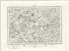
Ludlow (Outline) - OS One-Inch Revised New Series
1 : 63360 Topographic maps Ordnance Survey Ordnance Survey
Bromyard
Most of the common land in Hertsfordshire is included in this map, which covers Bromyard Down, Badley Wood, and Bringsty Common. Sutton Walls, an Iron Age hillfort, is north of the River Lugg. Budgen, T.
Bromyard
Most of the common land in Hertsfordshire is included in this map, which covers Bromyard Down, Badley Wood, and Bringsty Common. Sutton Walls, an Iron Age hillfort, is north of the River Lugg. Budgen, T.
New map of the county of Hereford, 2
1 Blatt : 71 x 58 cm s.n.
Kidderminster - OS One-Inch Map
1 : 63360 Topographic maps Ordnance Survey Ordnance Survey
Ludlow - OS One-Inch Map
1 : 63360 Topographic maps Ordnance Survey Ordnance Survey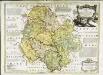
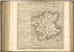
An accurate map of Hereford Shire
1 Karte : Kupferdruck ; 51 x 69 cm Bowen; Tinney sold by I. Tinney at the Golden Lion in Fleet street
Herefordia comitatvs
1 Karte : Kupferdruck ; 39 x 48 cm Blaeu Joan Blaeu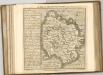

An accurate map of the county of Worcester
1 Karte : Kupferdruck ; 51 x 68 cm Bowen; Tinney; Bowles; Sayer; Bowles; Bowles sold by I. Tinney at the Golden Lion and R. Sayer at the Golden Buck in Fleet street T. Bowles in St. Pauls Church Yard and I. Bowles and son at the Black Horse in Cornhill
Shropshire, Sheet 17 - Bartholomew's "Half Inch to the Mile Maps" of England & Wales
1 : 126720 Topographic maps Bartholomew, John George John Bartholomew & Co
An accurate map of Shrop Shire
1 Karte : Kupferdruck ; 51 x 68 cm Bowen; Hinton sold by J. Hinton at the Kings Arms in St. Pauls Church Yard
Comitatvs Salopiensis; anglice Shrop Shire
1 Karte : Kupferdruck ; 37 x 48 cm Blaeu Joan Blaeu
HEREFORDIA | COMITATVS. | HEREFORD-SHIRE.
[Amsterdam : Joan Blaeu]