Maps of Stratford-on-Avon
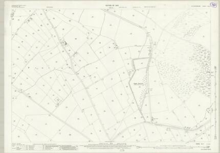
Warwickshire XLI.1 (includes: Grandborough; Lower Shuckburgh; Napton on The Hill; Stockton) - 25 Inch Map
1 : 2500 Topographic maps Ordnance Survey Ordnance Survey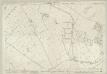
Warwickshire XLI.1 (includes: Grandborough; Lower Shuckburgh; Napton on The Hill; Stockton) - 25 Inch Map
1 : 2500 Topographic maps Ordnance Survey Ordnance Survey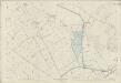
Warwickshire XLI.1 (includes: Grandborough; Lower Shuckburgh; Napton on The Hill; Stockton) - 25 Inch Map
1 : 2500 Topographic maps Ordnance Survey Ordnance Survey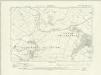
Warwickshire XLI.NW - OS Six-Inch Map
1 : 10560 Topographic maps Ordnance Survey Ordnance Survey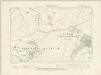
Warwickshire XLI.NW - OS Six-Inch Map
1 : 10560 Topographic maps Ordnance Survey Ordnance Survey
Warwickshire XLI.NW - OS Six-Inch Map
1 : 10560 Topographic maps Ordnance Survey Ordnance Survey
SP46 - OS 1:25,000 Provisional Series Map
1 : 25000 Topographic maps Ordnance Survey Ordnance Survey
Ladbroke
1 : 31680 This part of Warwickshire is dominated by enclosed land, characterised by regular hedgerows and fish ponds for watering stock. A section of the Oxford Canal, between Napton and Croperdy, is depicted in blue along the right side of the sheet. Completed in 1790, the canal was used to ferry coal from the north to Oxford. At top left, forming the boundary of the surveyed area, is the Fosse Way. This Roman road ran from Exeter to Lincoln via Bath, Cirencester and Leicester (where it intersected the Watling Street from London). At lower right, the county border between Warwickshire and Northamptonshire is indicated by a red dotted line. Stevens, Henry
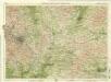
Daventry
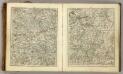
1 : 31680 Daventry is at lower right in this plan of part of Northamptonshire, situated near large canal-feeder reservoirs. Turnpike roads are highlighted in buff throughout the area. The money raised by such toll roads, established during the coaching era of the 18th century, raised money that contributed significantly to the development of the transport infrastructure of the county. Transport links in this area were further developed by the opening of the Oxford, Warwick and Grand Junction canals (highlighted in blue), which allowed new settlements and trades to flourish. Stevens, Henry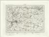
Warwick (Outline) - OS One-Inch Revised New Series
1 : 63360 Topographic maps Ordnance Survey Ordnance Survey
Warwick (Hills) - OS One-Inch Revised New Series
1 : 63360 Topographic maps Ordnance Survey Ordnance Survey
Towcester
1 : 31680 This drawing covers parts of Northamptonshire, Oxfordshire and Warwickshire. Different types of land use are distinguished symbolically, with relief indicated by brushstroke interlining ('hachuring'). The Watling Street is depicted down the right of the sheet forming the boundary of the surveyed area. This Roman road ran from London to Wroxeter in Wales, via St. Albans and Leicester (where it intersected the Fosse Way, the Roman road from Exeter to Lincoln).
Coventry and Rugby - OS One-Inch Map
1 : 63360 Topographic maps Ordnance Survey Ordnance Survey
The counti of Warwick the shire towne and citie of Coventre described
1 : 1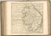
Birmingham, Leicester, Sheet 18 - Bartholomew's "Half Inch to the Mile Maps" of England & Wales
1 : 126720 Topographic maps Bartholomew, John George John Bartholomew & Co
Leicestrensis Comitatus. Leicester Shire. [Karte], in: Le théâtre du monde, ou, Nouvel atlas contenant les chartes et descriptions de tous les païs de la terre, Bd. 4, S. 287.
1 Karte aus Atlas Blaeu, Willem Janszoon und Blaeu, Joan Blaeu, Willem Janszoon
An accurate map of Northampton Shire
1 Karte : Kupferdruck ; 68 x 51 cm Bowen; Hinton sold by I. Hinton at the Kings Arms in Newgate street
Comitatvs Northantonensis vernacule Northamton Shire
1 Karte : Kupferdruck ; 37 x 49 cm Valck; Schenk prostant in officina penes Gerardi Valk et Petri Schenk
Comitatvs Northantonensis; vernacule Northamton Shire
1 Karte : Kupferdruck ; 40 x 48 cm Blaeu Joan Blaeu
Wigorniensis Comitatus cum Warwicensi, nec non Conventriae Libertas
1 : 180000 Amstelodami : apud Joannem Janssonium
Leicestrensis Comitatus. Leicester Shire. [Karte], in: Theatrum orbis terrarum, sive, Atlas novus, Bd. 4, S. 327.
1 Karte aus Atlas Blaeu, Joan Blaeu, Willem Janszoon
Leicestrensis Comitatus. Leicester Shire. [Karte], in: Theatrum orbis terrarum, sive, Atlas novus, Bd. 4, S. 327.
1 Karte aus Atlas Blaeu, Joan Blaeu, Willem Janszoon
Wigorniensis comitatus et comitatus Warwicensis; nec non Coventræ libertas
1 Karte : Kupferdruck ; 40 x 48 cm Blaeu Joan Blaeu
Buckinghamiensis Comitatus; Anglis Buckingham Shire. [Karte], in: Theatrum orbis terrarum, sive, Atlas novus, Bd. 4, S. 247.
1 Karte aus Atlas Blaeu, Joan Blaeu, Willem Janszoon
Buckinghamiensis Comitatus; Anglis Buckingham Shire. [Karte], in: Le théâtre du monde, ou, Nouvel atlas contenant les chartes et descriptions de tous les païs de la terre, Bd. 4, S. 219.
1 Karte aus Atlas Blaeu, Willem Janszoon und Blaeu, Joan Blaeu, Willem Janszoon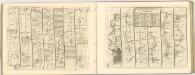

Buckinghamiensis Comitatus; Anglis Buckingham Shire. [Karte], in: Theatrum orbis terrarum, sive, Atlas novus, Bd. 4, S. 247.
1 Karte aus Atlas Blaeu, Joan Blaeu, Willem Janszoon
Wigorniensis Comitatus cum Warwicensi; nec non Conventriae Libertas. [Karte], in: Novus atlas absolutissimus, Bd. 7, S. 342.
1 Karte aus Atlas Janssonius Offizin