Maps of Warwickshire
Staffordshire LVIII.1 (includes: Burntwood; Hammerwich; Wall) - 25 Inch Map
1 : 2500 Topographic maps Ordnance Survey Ordnance Survey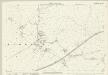
Staffordshire LVIII.1 (includes: Burntwood; Hammerwich; Wall) - 25 Inch Map
1 : 2500 Topographic maps Ordnance Survey Ordnance Survey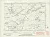
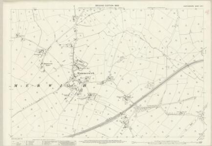
Staffordshire LVIII.NW - OS Six-Inch Map
1 : 10560 Topographic maps Ordnance Survey Ordnance Survey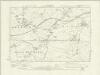
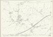
Staffordshire LVIII.NW - OS Six-Inch Map
1 : 10560 Topographic maps Ordnance Survey Ordnance Survey
Staffordshire LVIII.NW - OS Six-Inch Map
1 : 10560 Topographic maps Ordnance Survey Ordnance Survey
Staffordshire LVIII.NW - OS Six-Inch Map
1 : 10560 Topographic maps Ordnance Survey Ordnance Survey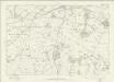
Staffordshire LVIII - OS Six-Inch Map
1 : 10560 Topographic maps Ordnance Survey Ordnance Survey
SK00 - OS 1:25,000 Provisional Series Map
1 : 25000 Topographic maps Ordnance Survey Ordnance Survey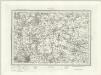
Lichfield (Outline) - OS One-Inch Revised New Series
1 : 63360 Topographic maps Ordnance Survey Ordnance Survey
Lichfield (Hills) - OS One-Inch Revised New Series
1 : 63360 Topographic maps Ordnance Survey Ordnance Survey
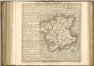
Wolverhampton 10
1 : 31680 This plan covers part of the English Midland plateau. The Staffordshire and Worcestershire Canal is depicted down the left side. Opened for traffic in May 1772, the canal was built by engineer James Brindley as part of his 'Grand Cross', a far-sighted scheme to link the ports of Hull, Liverpool and Bristol by connecting the rivers Mersey, Trent and Severn. Work on a second waterway, the Birmingham Canal, started a year later to facilitate the transport of coal from the pits of the Black Country to Birmingham. The Industrial Revolution saw over 180 miles of canals and 216 locks built. Part of this network is visible on the plan highlighted in blue. Dawson, Robert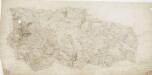
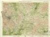
Lichfield
1 : 31680 This plan covers part of East Staffordshire and its neighbouring counties. County borders are highlighted by coloured pecked lines. The large heath of Cannock Chase, once an expansive sweep of a great medieval royal hunting forest, is depicted at lower left. A section of the Ryknild Street is shown in buff down the middle of the sheet. This Roman road ran from the Fosse Way in Gloucestershire to Little Chester (Derby). Triangles used by Dawson to plot the survey are clearly visible outside the plan, with triangulations reported in a table at bottom right. Dawson, Robert
Burton upon Trent - OS One-Inch Map
1 : 63360 Topographic maps Ordnance Survey Ordnance Survey
An improved map of the county of Stafford
1 Karte : Kupferdruck ; 67 x 51 cm Bowen; Hinton sold by I. Hinton at the Kings Arms in St. Pauls Church Yard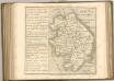
Birmingham, Leicester, Sheet 18 - Bartholomew's "Half Inch to the Mile Maps" of England & Wales
1 : 126720 Topographic maps Bartholomew, John George John Bartholomew & Co
Staffordiensis comitatvs; vulgo Stafford Shire
1 Karte : Kupferdruck ; 39 x 49 cm Blaeu Joan Blaeu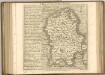

Wigorniensis Comitatus cum Warwicensi, nec non Conventriae Libertas
1 : 180000 Amstelodami : apud Joannem Janssonium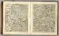
Sheets 31-32. (Cary's England, Wales, and Scotland).
1 : 360000 Cary, John, ca. 1754-1835
Wigorniensis comitatus et comitatus Warwicensis; nec non Coventræ libertas
1 Karte : Kupferdruck ; 40 x 48 cm Blaeu Joan Blaeu
Wigorniensis Comitatus cum Warwicensi; nec non Conventriae Libertas. [Karte], in: Novus atlas absolutissimus, Bd. 7, S. 342.
1 Karte aus Atlas Janssonius Offizin

DARBIENSIS | COMITATVS. | Vernacule | DARBIE SHIRE
[Amsterdam : Joan Blaeu]
WIGORNIENSIS | Comitatus et Comitatus | WARWICENSIS| nec non | COVENTRÆ LIBERTAS | WORCESTER, WARWIK SHIRE. | and THE LIBERTY OF COVENTRE.
[Amsterdam : Joan Blaeu]
Comitatus Darbiensis
1 : 240000 [Amstelodami] : [apud Joannem Janssonium]
COMITATVS | SALOPIENSIS; | Anglice | SHROP SHIRE.
[Amsterdam : Joan Blaeu]
STAFFORDIENSIS | COMITATVS; | Vulgo | STAFFORD SHIRE.
[Amsterdam : Joan Blaeu]