Maps of South Cambridgeshire
Cambridgeshire LIV.2 (includes: Great Shelford; Harston; Hauxton; Little Shelford; Sawston) - 25 Inch Map
1 : 2500 Topographic maps Ordnance Survey Ordnance Survey
Cambridgeshire LIV.2 (includes: Great Shelford; Harston; Hauxton; Little Shelford; Sawston) - 25 Inch Map
1 : 2500 Topographic maps Ordnance Survey Ordnance Survey
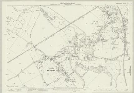
Cambridgeshire LIV.NW - OS Six-Inch Map
1 : 10560 Topographic maps Ordnance Survey Ordnance Survey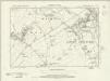
Cambridgeshire LIV.NW - OS Six-Inch Map
1 : 10560 Topographic maps Ordnance Survey Ordnance Survey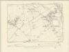
Cambridgeshire LIV.NW - OS Six-Inch Map
1 : 10560 Topographic maps Ordnance Survey Ordnance Survey
Cambridgeshire LIV.NW - OS Six-Inch Map
1 : 10560 Topographic maps Ordnance Survey Ordnance Survey
TL45 - OS 1:25,000 Provisional Series Map
1 : 25000 Topographic maps Ordnance Survey Ordnance Survey
Saffron Walden (Hills) - OS One-Inch Revised New Series
1 : 63360 Topographic maps Ordnance Survey Ordnance Survey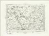
Saffron Walden (Outline) - OS One-Inch Revised New Series
1 : 63360 Topographic maps Ordnance Survey Ordnance Survey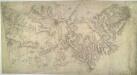
Cambridge 23
1 : 31680 Two types of landscapes characterise this part of Cambridgeshire. South of the City of Cambridge itself, a broad band of low, rolling chalk hills is intersected by river valleys. By contrast, the landscape at top right is fenland where arable expanses are divided by straight, water-filled dykes. Hyett, William
Cambridge and Ely - OS One-Inch Map
1 : 63360 Topographic maps Ordnance Survey Ordnance Survey
Saffron Walden - OS One-Inch Map
1 : 63360 Topographic maps Ordnance Survey Ordnance Survey
Huntingdonensis Comitatus; Huntington Shire. [Karte], in: Le théâtre du monde, ou, Nouvel atlas contenant les chartes et descriptions de tous les païs de la terre, Bd. 4, S. 277.
1 Karte aus Atlas Blaeu, Willem Janszoon und Blaeu, Joan Blaeu, Willem Janszoon
Huntingdonensis Comitatus Huntingtonshire. [Karte], in: Novus atlas absolutissimus, Bd. 7, S. 301.
1 Karte aus Atlas Janssonius Offizin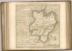

Cary's Improved Map of England and Wales
Cary, George, & Cary, John London : G. & J. Cary
Hertfordia comitatvs vernacule Hertfordshire
1 Karte : Kupferdruck ; 37 x 48 cm Blaeu Joan Blaeu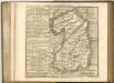

Cantabrigiensis comitatvs
1 Karte : Kupferdruck ; 41 x 51 cm Blaeu Joan Blaeu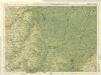
Cambridge, Huntingdon, Sheet 19 - Bartholomew's "Half Inch to the Mile Maps" of England & Wales
1 : 126720 Topographic maps Bartholomew, John George John Bartholomew & Co
Comitatis Cantabrigiensis; vernacule Cambridge Shire
1 Karte : Kupferdruck ; 40 x 50 cm Valck; Schenk venditant Gerardus Valk et Petrus Schenk
Bedford, Hertford, Sheet 25 - Bartholomew's "Half Inch to the Mile Maps" of England & Wales
1 : 126720 Topographic maps Bartholomew, John George John Bartholomew & Co
Cambridgeshire
1 : 390000 Hall, Sidney Chapmann & Hall
Middelsexiae cum Hertfordiae comitatu: Midlesex & Hertford Shire. [Karte], in: Novus atlas absolutissimus, Bd. 7, S. 246.
1 Karte aus Atlas Janssonius Offizin
Regiones Inundatae In finibus Comitatus Norfolciae, Suffolciae, Cantabrigiae, Huntingtoniae[,] Northamtoniae, et Lincolniae [Karte], in: Theatrum orbis terrarum, sive, Atlas novus, Bd. 4, S. 301.
1 Karte aus Atlas Blaeu, Joan Blaeu, Willem Janszoon
Regiones Inundatae In finibus Comitatus Norfolciae, Suffolciae, Cantabrigiae, Huntingtoniae Northamtoniae, et Lincolniae [Karte], in: Le théâtre du monde, ou, Nouvel atlas contenant les chartes et descriptions de tous les païs de la terre, Bd. 4, S. 265.
1 Karte aus Atlas Blaeu, Willem Janszoon und Blaeu, Joan Blaeu, Willem Janszoon
CANTABRIGIENSIS | COMITATVS; | CAMBRIDGE SHIRE.
[Amsterdam : Joan Blaeu]
Comitatis Cantabrigiensis, vernacule Cambridge Shire
1 : 210000 Amstelodami : apud Joannem Janssonium
Essexia comitatvs
1 Karte : Kupferdruck ; 40 x 51 cm Blaeu Joan Blaeu