Maps of East Cambridgeshire
Cambridgeshire XXII.14 (includes: Downham; Littleport) - 25 Inch Map
1 : 2500 Topographic maps Ordnance Survey Ordnance Survey
Cambridgeshire XXII.14 (includes: Downham; Littleport) - 25 Inch Map
1 : 2500 Topographic maps Ordnance Survey Ordnance Survey
Cambridgeshire XXII.SW - OS Six-Inch Map
1 : 10560 Topographic maps Ordnance Survey Ordnance Survey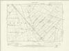
Cambridgeshire XXII.SW - OS Six-Inch Map
1 : 10560 Topographic maps Ordnance Survey Ordnance Survey
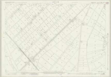
Cambridgeshire XXII.SW - OS Six-Inch Map
1 : 10560 Topographic maps Ordnance Survey Ordnance Survey
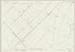
Cambridgeshire XXII.SW - OS Six-Inch Map
1 : 10560 Topographic maps Ordnance Survey Ordnance Survey
TL58 - OS 1:25,000 Provisional Series Map
1 : 25000 Topographic maps Ordnance Survey Ordnance Survey
Ely (Hills) - OS One-Inch Revised New Series
1 : 63360 Topographic maps Ordnance Survey Ordnance Survey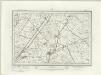
Ely (Outline) - OS One-Inch Revised New Series
1 : 63360 Topographic maps Ordnance Survey Ordnance Survey
March
1 : 31680 This drawing covers the Bedford Level and part of the East Anglian fens, with the town of Wisbech shown at top left. Drains across fens and marshland are highlighted in blue. These date from the 17th century, when James I appointed the Dutch engineer, Cornelius Vermuyden to direct drainage of the wetlands. Many local people opposed the scheme because the land involved was commonland on which they grazed cattle. As a result of Vermuyden's work, the fens became a very different landscape, transformed from one of flooded marshes to extensively farmed agricultural land. Yeakell, Thomas Jr.
Littleport
1 : 31680 This drawing covers part of the Cambridgeshire fenland, an area characterised by straight, water-filled dykes dividing arable land. The New Bedford River is shown running down the middle of the sheet, almost parallel to the original Old Bedford River, taking the waters of the Great Ouse to Denver Sluice, at top right of the plan. In the 17th century, the Dutch engineer, Cornelius Vermuyden was appointed by James I to direct the drainage of the wetlands. As a result of Vermuyden's work, the fens took on a very different appearance, changing from an area of flooded marshes to one of extensively farmed agricultural land. Yeakell, Thomas Jr.Draughtsman
HVNTINGDO- | NENSIS COMITATVS; | HUNTINGTON SHIRE.
[Amsterdam : Joan Blaeu]
Cambridge and Ely - OS One-Inch Map
1 : 63360 Topographic maps Ordnance Survey Ordnance Survey
Huntingdonensis Comitatus = Huntington Shire
1 : 130000 [Amstelodami] : [apud Joannem Janssonium]
Huntingdonensis Comitatus; Huntington Shire. [Karte], in: Theatrum orbis terrarum, sive, Atlas novus, Bd. 4, S. 315.
1 Karte aus Atlas Blaeu, Joan Blaeu, Willem Janszoon
Huntingdonensis Comitatus; Huntington Shire. [Karte], in: Theatrum orbis terrarum, sive, Atlas novus, Bd. 4, S. 315.
1 Karte aus Atlas Blaeu, Joan Blaeu, Willem Janszoon
Huntingdonensis Comitatus; Huntington Shire. [Karte], in: Le théâtre du monde, ou, Nouvel atlas contenant les chartes et descriptions de tous les païs de la terre, Bd. 4, S. 277.
1 Karte aus Atlas Blaeu, Willem Janszoon und Blaeu, Joan Blaeu, Willem Janszoon
Huntingdonensis Comitatus Huntingtonshire. [Karte], in: Novus atlas absolutissimus, Bd. 7, S. 301.
1 Karte aus Atlas Janssonius Offizin
Cary's Improved Map of England and Wales
Cary, George, & Cary, John London : G. & J. Cary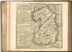

Cantabrigiensis comitatvs
1 Karte : Kupferdruck ; 41 x 51 cm Blaeu Joan Blaeu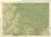
Cambridge, Huntingdon, Sheet 19 - Bartholomew's "Half Inch to the Mile Maps" of England & Wales
1 : 126720 Topographic maps Bartholomew, John George John Bartholomew & Co
Comitatis Cantabrigiensis; vernacule Cambridge Shire
1 Karte : Kupferdruck ; 40 x 50 cm Valck; Schenk venditant Gerardus Valk et Petrus Schenk
REGIONES | INVNDATÆ | In finibus Comitatus | NORFOLCIÆ, SUFFOLCIÆ, | CANTABRIGIÆ, HVNTINGTONIÆ | NORTHAMTONIÆ, et | LINCOLNIÆ
[Amsterdam : Joan Blaeu]
A general plott and description of the Fennes and surounded grounds in the sixe counties of Norfolke, Suffolke, Cambridge, with in the Isle of Ely, Huntington, Northampton and Lincolne etc.
1 : 180000 Amstelodami : sumptibus Joannis Janssonii
Cambridgeshire
1 : 390000 Hall, Sidney Chapmann & Hall
Regiones Inundatae In finibus Comitatus Norfolciae, Suffolciae, Cantabrigiae, Huntingtoniae[,] Northamtoniae, et Lincolniae [Karte], in: Theatrum orbis terrarum, sive, Atlas novus, Bd. 4, S. 301.
1 Karte aus Atlas Blaeu, Joan Blaeu, Willem Janszoon
A general Plot and description of the Fennes and surounded grounds in the sixe Counties of Norfolke, Suffolke, Cambridge [...] [Karte], in: Novus atlas absolutissimus, Bd. 7, S. 306.
1 Karte aus Atlas Janssonius Offizin
A general plott and description of the Fennes and surounded grounds in the sixe counties of Norfolke, Suffolke, Cambridge
1 Karte : Kupferdruck ; 44 x 55 cm Valck; Schenk sumptibus G. Valk et P. Schenk
Regiones invndatæ in finibus comitatus Norfolciæ, Svffolciæ, Cantabrigiæ, Hvntingtoniæ Northamtoniæ, et Lincolniæ
1 Karte : Kupferdruck ; 43 x 54 cm Blaeu Joan Blaeu