Maps of Milton Keynes
Northamptonshire LII.11 (includes: Hackleton) - 25 Inch Map
1 : 2500 Topographic maps Ordnance Survey Ordnance Survey
Northamptonshire LII.11 (includes: Hackleton) - 25 Inch Map
1 : 2500 Topographic maps Ordnance Survey Ordnance Survey
Buckinghamshire I.SE - OS Six-Inch Map
1 : 10560 Topographic maps Ordnance Survey Ordnance Survey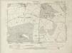
Buckinghamshire I.SE - OS Six-Inch Map
1 : 10560 Topographic maps Ordnance Survey Ordnance Survey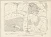
Buckinghamshire I.SE - OS Six-Inch Map
1 : 10560 Topographic maps Ordnance Survey Ordnance Survey
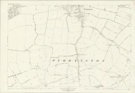
Northamptonshire LII.SE - OS Six-Inch Map
1 : 10560 Topographic maps Ordnance Survey Ordnance Survey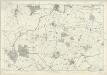
Buckinghamshire IV (inset I) - OS Six-Inch Map
1 : 10560 Topographic maps Ordnance Survey Ordnance Survey
Towcester (Hills) - OS One-Inch Revised New Series
1 : 63360 Topographic maps Ordnance Survey Ordnance Survey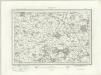
Towcester (Outline) - OS One-Inch Revised New Series
1 : 63360 Topographic maps Ordnance Survey Ordnance Survey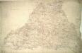
Stony Stratford
1 : 31680 The county boundary of Buckinghamshire and Northamptonshire is depicted to the right of the sheet as a red pecked line. It can be seen following sections of the River Ouse. Two ancient forests are also shown: the Royal Forest of Whittlewood, a medieval hunting forest, is at middle left; and Salcey Forest, the heart of the ancient woodland belt of the East Midlands, is shown at top left. A section of the Watling Street is indicated from bottom left to top right. This ancient Roman road ran from London to Wroxeter in Wales, via St. Albans and Leicester (where it intersected the Fosse Way, the Roman road from Exeter to Lincoln). Boyce
Northampton
1 : 31680 This drawing covers part of the Nene Valley as the river meanders through farmland and the industries of Northamptonshire. Mills are depicted throughout the area, especially along the river's course. The staples of Northamptonshire's industry at the beginning of the 19th century were wool, lace, silk and shoemaking. With no indigenous coal supply, local industrialists relied principally upon natural resources for industrial processing, particularly wind and water. Hyett, William
Buckingham - OS One-Inch Map
1 : 63360 Topographic maps Ordnance Survey Ordnance Survey
Northampton - OS One-Inch Map
1 : 63360 Topographic maps Ordnance Survey Ordnance Survey
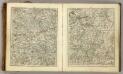
[Left] BEDFORDIENSIS | COMITATVS; | Anglis | BEDFORD SHIRE. [right] BVCKINGHAMI- | ENSIS COMITATVS; | Anglis | BUCKINGHAM SHIRE.
[Amsterdam : Joan Blaeu]
Bedfordiensis Comitatus; Anglis Bedford Shire. [Karte], in: Le théâtre du monde, ou, Nouvel atlas contenant les chartes et descriptions de tous les païs de la terre, Bd. 4, S. 218.
1 Karte aus Atlas Blaeu, Willem Janszoon und Blaeu, Joan Blaeu, Willem Janszoon
Bedfordiensis Comitatus; Anglis Bedford Shire. [Karte], in: Theatrum orbis terrarum, sive, Atlas novus, Bd. 4, S. 246.
1 Karte aus Atlas Blaeu, Joan Blaeu, Willem Janszoon
Bedfordiensis Comitatus; Anglis Bedford Shire. [Karte], in: Theatrum orbis terrarum, sive, Atlas novus, Bd. 4, S. 246.
1 Karte aus Atlas Blaeu, Joan Blaeu, Willem Janszoon
An accurate map of Buckingham Shire
1 Karte : Kupferdruck ; 69 x 52 cm Bowen; Tinney; Bowles; Sayer; Bowles; Bowles sold by I. Tinney at the golden lion and R. Sayer at the golden buck in Fleet street T. Bowles in St. Pauls Church yard and I. Bowles and son in Cornhill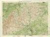
Oxford, Sheet 24 - Bartholomew's "Half Inch to the Mile Maps" of England & Wales
1 : 126720 Topographic maps Bartholomew, John George John Bartholomew & Co
England & Wales [Bartholomew's "Half-inch to the mile" Map of]
J. Bartholomew
Buckingamiæ comitatvs cum Bedfordiensi; vulgo Buckingamshire and Bedfordshire
1 Karte : Kupferdruck ; 38 x 48 cm Valck; Schenk penes Gerardum Valk et Petrum Schenk

An accurate map of Northampton Shire
1 Karte : Kupferdruck ; 68 x 51 cm Bowen; Hinton sold by I. Hinton at the Kings Arms in Newgate street
Comitatvs Northantonensis vernacule Northamton Shire
1 Karte : Kupferdruck ; 37 x 49 cm Valck; Schenk prostant in officina penes Gerardi Valk et Petri Schenk
Comitatvs Northantonensis; vernacule Northamton Shire
1 Karte : Kupferdruck ; 40 x 48 cm Blaeu Joan Blaeu
Buckinghamiensis Comitatus; Anglis Buckingham Shire. [Karte], in: Theatrum orbis terrarum, sive, Atlas novus, Bd. 4, S. 247.
1 Karte aus Atlas Blaeu, Joan Blaeu, Willem Janszoon
Buckinghamiensis Comitatus; Anglis Buckingham Shire. [Karte], in: Le théâtre du monde, ou, Nouvel atlas contenant les chartes et descriptions de tous les païs de la terre, Bd. 4, S. 219.
1 Karte aus Atlas Blaeu, Willem Janszoon und Blaeu, Joan Blaeu, Willem Janszoon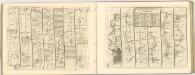

Buckinghamiensis Comitatus; Anglis Buckingham Shire. [Karte], in: Theatrum orbis terrarum, sive, Atlas novus, Bd. 4, S. 247.
1 Karte aus Atlas Blaeu, Joan Blaeu, Willem Janszoon