Maps of Daventry
Northamptonshire XXXI.14 (includes: Brixworth; Holcot; Old; Scaldwell; Walgrave) - 25 Inch Map
1 : 2500 Topographic maps Ordnance Survey Ordnance Survey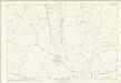
Northamptonshire XXXI.14 (includes: Brixworth; Holcot; Old; Scaldwell; Walgrave) - 25 Inch Map
1 : 2500 Topographic maps Ordnance Survey Ordnance Survey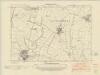
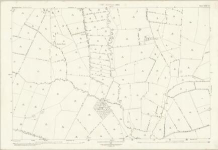
Northamptonshire XXXI.SW - OS Six-Inch Map
1 : 10560 Topographic maps Ordnance Survey Ordnance Survey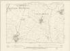
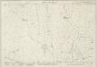
Northamptonshire XXXI.SW - OS Six-Inch Map
1 : 10560 Topographic maps Ordnance Survey Ordnance Survey
Northamptonshire XXXI.SW - OS Six-Inch Map
1 : 10560 Topographic maps Ordnance Survey Ordnance Survey
SP77 - OS 1:25,000 Provisional Series Map
1 : 25000 Topographic maps Ordnance Survey Ordnance Survey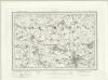
Northampton (Outline) - OS One-Inch Revised New Series
1 : 63360 Topographic maps Ordnance Survey Ordnance Survey
Northampton (Hills) - OS One-Inch Revised New Series
1 : 63360 Topographic maps Ordnance Survey Ordnance Survey
Kettering
1 : 31680 This finished drawing covers parts of Northamptonshire and Leicestershire, with Rockingham Forest to the north represented by stippled treetops. Situated between the Welland and Nene valleys, and the towns of Stamford and Kettering, the forest's varied landscape includes farmland, open pasture, villages and pockets of woodland. Boughton Hall is depicted in the middle of the sheet. Formerly a monastery, it was transformed into one of the great houses of Europe in the 17th century. Hyett, William
Northampton
1 : 31680 This drawing covers part of the Nene Valley as the river meanders through farmland and the industries of Northamptonshire. Mills are depicted throughout the area, especially along the river's course. The staples of Northamptonshire's industry at the beginning of the 19th century were wool, lace, silk and shoemaking. With no indigenous coal supply, local industrialists relied principally upon natural resources for industrial processing, particularly wind and water. Hyett, William
Northampton - OS One-Inch Map
1 : 63360 Topographic maps Ordnance Survey Ordnance Survey
Bedfordiensis Comitatus; Anglis Bedford Shire. [Karte], in: Theatrum orbis terrarum, sive, Atlas novus, Bd. 4, S. 246.
1 Karte aus Atlas Blaeu, Joan Blaeu, Willem Janszoon
Bedfordiensis Comitatus; Anglis Bedford Shire. [Karte], in: Theatrum orbis terrarum, sive, Atlas novus, Bd. 4, S. 246.
1 Karte aus Atlas Blaeu, Joan Blaeu, Willem Janszoon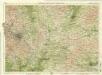
Birmingham, Leicester, Sheet 18 - Bartholomew's "Half Inch to the Mile Maps" of England & Wales
1 : 126720 Topographic maps Bartholomew, John George John Bartholomew & Co
LEICESTRENSIS | COMITATVS. | LEICESTER SHIRE.
[Amsterdam : Joan Blaeu]
Leicestrensis Comitatus cum Rutlandiae. Vulgo Leicester & Rutland Shire. [Karte], in: Novus atlas absolutissimus, Bd. 7, S. 316.
1 Karte aus Atlas Janssonius Offizin
Leicestrensis Comitatus. Leicester Shire. [Karte], in: Le théâtre du monde, ou, Nouvel atlas contenant les chartes et descriptions de tous les païs de la terre, Bd. 4, S. 287.
1 Karte aus Atlas Blaeu, Willem Janszoon und Blaeu, Joan Blaeu, Willem Janszoon
An accurate map of Northampton Shire
1 Karte : Kupferdruck ; 68 x 51 cm Bowen; Hinton sold by I. Hinton at the Kings Arms in Newgate street
Comitatvs Northantonensis vernacule Northamton Shire
1 Karte : Kupferdruck ; 37 x 49 cm Valck; Schenk prostant in officina penes Gerardi Valk et Petri Schenk
Comitatvs Northantonensis; vernacule Northamton Shire
1 Karte : Kupferdruck ; 40 x 48 cm Blaeu Joan Blaeu
Leicestrensis Comitatus. Leicester Shire. [Karte], in: Theatrum orbis terrarum, sive, Atlas novus, Bd. 4, S. 327.
1 Karte aus Atlas Blaeu, Joan Blaeu, Willem Janszoon
Leicestrensis Comitatus. Leicester Shire. [Karte], in: Theatrum orbis terrarum, sive, Atlas novus, Bd. 4, S. 327.
1 Karte aus Atlas Blaeu, Joan Blaeu, Willem Janszoon
Buckinghamiensis Comitatus; Anglis Buckingham Shire. [Karte], in: Theatrum orbis terrarum, sive, Atlas novus, Bd. 4, S. 247.
1 Karte aus Atlas Blaeu, Joan Blaeu, Willem Janszoon
Buckinghamiensis Comitatus; Anglis Buckingham Shire. [Karte], in: Le théâtre du monde, ou, Nouvel atlas contenant les chartes et descriptions de tous les païs de la terre, Bd. 4, S. 219.
1 Karte aus Atlas Blaeu, Willem Janszoon und Blaeu, Joan Blaeu, Willem Janszoon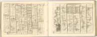

Buckinghamiensis Comitatus; Anglis Buckingham Shire. [Karte], in: Theatrum orbis terrarum, sive, Atlas novus, Bd. 4, S. 247.
1 Karte aus Atlas Blaeu, Joan Blaeu, Willem Janszoon
Sheets 33-34. (Cary's England, Wales, and Scotland).
1 : 360000 Cary, John, ca. 1754-1835
Buckingamiae comitatus cum Bedfordiensi, vulgo Buckingamshire and Bedfordfhire
1 : 180000 Amstelodami : apud Joannem Janssonium
Map of Northhamptonshire, Bedfordshire, Cambridgeshire, Huntigdonshire and Rutland
This is a manuscript map of Northamptonshire, Bedfordshire, Cambridgeshire, Huntingdonshire and Rutland, a page from an atlas that belonged to William Cecil Lord Burghley, Elizabeth I’s Secretary of State. Burghley used this atlas to illustrate domestic matters.It is in a hand pre dating 1570 and may be the work of John Rudd. Rudd was the man to whom Christopher Saxton was an apprentice to in 1570. John Rudd was Vicar of Dewsbury from 1554 to 1570. Rudd had a keen interest in cartography and had been engaged in the 1550’s in making a platt’ of England. In 1561 Rudd was granted leave to travel further to map the country and it is likely that Saxton accompanied him, acquiring his skills for surveying. Rudd, John