Maps of Forest of Dean
Gloucestershire XLVIII.14 (includes: Alkington; Cam; Hamfallow; Stinchcombe) - 25 Inch Map
1 : 2500 Topographic maps Ordnance Survey Ordnance Survey
Gloucestershire XLVIII.14 (includes: Alkington; Cam; Hamfallow; Stinchcombe) - 25 Inch Map
1 : 2500 Topographic maps Ordnance Survey Ordnance Survey
Gloucestershire XLVIII.14 (includes: Alkington; Cam; Hamfallow; Stinchcombe) - 25 Inch Map
1 : 2500 Topographic maps Ordnance Survey Ordnance Survey
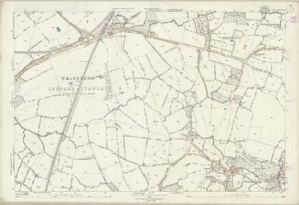
Gloucestershire XLVIII.SW - OS Six-Inch Map
1 : 10560 Topographic maps Ordnance Survey Ordnance Survey
Gloucestershire XLVIII.SW - OS Six-Inch Map
1 : 10560 Topographic maps Ordnance Survey Ordnance Survey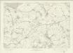
Gloucestershire XLVIII - OS Six-Inch Map
1 : 10560 Topographic maps Ordnance Survey Ordnance Survey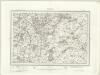
Malmesbury (Outline) - OS One-Inch Revised New Series
1 : 63360 Topographic maps Ordnance Survey Ordnance Survey
Malmesbury (Hills) - OS One-Inch Revised New Series
1 : 63360 Topographic maps Ordnance Survey Ordnance Survey
Stroud
The stunning landscapes in this part of the Costwolds is captured by the skillful and artistic use of hachures, lines and color to indicate slope and landcover on the map. Crocker, E.
Chepstow
1 : 31680 Thomas Budgen surveyed the majority of the Welsh plans, and is probably author of this drawing of the Severn Estuary. The plan is a good example of the use of black and red ink to distinguish between wooden and masonry structures. Chepstow Bridge, on the River Wye, is illustrated with red piers and a black roadway. Budgen, Thomas
Bristol and Stroud - OS One-Inch Map
1 : 63360 Topographic maps Ordnance Survey Ordnance Survey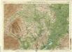
Hereford, Sheet 23 - Bartholomew's "Half Inch to the Mile Maps" of England & Wales
1 : 126720 Topographic maps Bartholomew, John George John Bartholomew & Co
Monumethensis Comitatus. Vernacule Monmouth Shire. [Karte], in: Theatrum orbis terrarum, sive, Atlas novus, Bd. 4, S. 404.
1 Karte aus Atlas Blaeu, Joan Blaeu, Willem Janszoon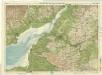
Bath & Bristol, Sheet 28 - Bartholomew's "Half Inch to the Mile Maps" of England & Wales
1 : 126720 Topographic maps Bartholomew, John George John Bartholomew & Co
Monumethensis Comitatus. Vernacule Monmouth Shire. [Karte], in: Le théâtre du monde, ou, Nouvel atlas contenant les chartes et descriptions de tous les païs de la terre, Bd. 4, S. 350.
1 Karte aus Atlas Blaeu, Willem Janszoon und Blaeu, Joan Blaeu, Willem Janszoon
Monumethensis Comitatus. Vernacule Monmouth Shire. [Karte], in: Theatrum orbis terrarum, sive, Atlas novus, Bd. 4, S. 404.
1 Karte aus Atlas Blaeu, Joan Blaeu, Willem Janszoon
Wiltonia sive Comitatus Wiltoniensis anglis Wil Shire
1 : 210000 Amstelodami : apud Joannem Janssonium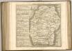

WILTONIAE Comitatus
This is a map of Wiltshire by Christopher Saxton which dates from 1576. It forms part of an atlas that belonged to William Cecil Lord Burghley, Elizabeth I’s Secretary of State. Burghley used this atlas to illustrate domestic matters. This map is actually a proof copy of one which forms part of Christopher Saxton’s Atlas of England and Wales. This atlas was first published as a whole in 1579. It consists of 35 coloured maps depicting the counties of England and Wales. The atlas is of great significance to British cartography as it set a standard of cartographic representation in Britain and the maps remained the basis for English county mapping, with few exceptions, until after 1750. During the reign of Elizabeth I, map use became more common, with many government matters referring to increasingly accurate maps with consistent scales and symbols, made possible by advances in surveying techniques. Illustrating the increasing use of maps in government matters, Lord Burghley, who had been determined to have England and Wales mapped in detail from the 1550s, selected the cartographer Christopher Saxton to produce a detailed and consistent survey of the country. The financier of the project was Thomas Seckford Master of Requests at the Court of Elizabeth I, whose arms appear, along with the royal crest on each map .Lord Burghley has added several place names to the map. This map was engraved by Remigius Hogenbergius, one of a team of seven English and Flemish engravers employed to produce the copper plates for the atlas. Saxton, Christopher Hogenbergius, Remigius
WILTONIA | sive | COMITATVS WILTONI- | ENSIS; Anglis | WIL SHIRE.
[Amsterdam : Joan Blaeu]
Glocestria dvcatvs; vulgo Glocester Shire
1 Karte : Kupferdruck ; 40 x 48 cm Blaeu Joan Blaeu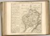

WILTONIAE
This map of Wiltshire is from the 1583 edition of the Saxton atlas of England and Wales. TThis atlas was first published as a whole in 1579. It consists of 35 coloured maps depicting the counties of England and Wales. The atlas is of great significance to British cartography as it set a standard of cartographic representation in Britain and the maps remained the basis for English county mapping, with few exceptions, until after 1750. During the reign of Elizabeth I map use became more common, with many government matters referring to increasingly accurate maps with consistent scales and symbols, made possible by advances in surveying techniques. Illustrating the increasing used of maps in government matters, Lord Burghley, Elizabeth I’s Secretary of State, who had been determined to have England and Wales mapped in detail from the 1550s, selected the cartographer Christopher Saxton to produce a detailed and consistent survey of the country. The financier of the project was Thomas Seckford Master of Requests at the Court of Elizabeth I, whose arms appear, along with the royal crest, on each map. Saxton’s name appears in the decorative scale bar as does the name of the engraver of this map, Remigius Hogenberg ,one of seven English and Flemish engravers employed to produced the copper plates for the atlas. Relief, in the form of uniform rounded representations of hills, is the main topographical feature presented in the maps. Rather than provide a scientific representation of relative relief these give a general impression of the lie of the land. Settlements and notable buildings are also recorded pictorially; a small building with a spire represents a village, while more important towns are indicated by groups of buildings. Here Stonehenge is marked by a pictorial representation and named The Stonadge’. Saxton, Christopher Ryther, Augustine
Glocestria dvcatvs, Monvmethensi comitatu
1 Karte : Kupferdruck ; 39 x 49 cm Valck; Schenk penes G. Valk et P. Schenk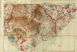
South Wales and the border in the 14th century
Rees, William Ordnance Survey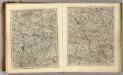
Sheets 23-24. (Cary's England, Wales, and Scotland).
1 : 360000 Cary, John, ca. 1754-1835
Map of Worcestershire
This is a manuscript map of Worcestershire. The date and draughtsman are not known. It forms part of an atlas that belonged to William Cecil Lord Burghley, Elizabeth I’s Secretary of State. Burghley used this atlas to illustrate domestic matters. The dominant features of the landscape are the waterways and the parks which are shown by symbols of fenced enclosures. These were of central importance to any military campaign. The fastest way to move a lot of men and weaponry was by river and parks provided somewhere for troops to set up camp and for horses to graze. Lord Burghley has annotated the map. In the left margin he has added a list of residents of the area and what lands and properties they are associated with, inserting some of these into the map itself. This is a good indication of how detailed was the knowledge accumulated by Burghley. William Cecil, Lord Burghley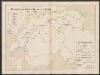
Wiltonia sive Comitatus Wiltoniensis; Anglis Wilshire. [Karte], in: Le théâtre du monde, ou, Nouvel atlas contenant les chartes et descriptions de tous les païs de la terre, Bd. 4, S. 145.
1 Karte aus Atlas Blaeu, Willem Janszoon und Blaeu, Joan Blaeu, Willem Janszoon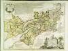
An accurate map of the counties Gloucester and Monmouth
1 Karte : Kupferdruck ; 51 x 66 cm Tinney; Bowles; Sayer; Bowles; Bowles printed for T. Bowles in St. Pauls Church Yard Rob.t Sayer and John Tinney in Fleet Street and John Bowles and son in Cornhil