Maps of Wiltshire
Wiltshire XLII.5 (includes: Milton Lilbourne; Pewsey) - 25 Inch Map
1 : 2500 Topographic maps Ordnance Survey Ordnance Survey
Wiltshire XLII.5 (includes: Milton Lilbourne; Pewsey) - 25 Inch Map
1 : 2500 Topographic maps Ordnance Survey Ordnance Survey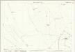
Wiltshire XLII.5 (includes: Milton Lilbourne; Pewsey) - 25 Inch Map
1 : 2500 Topographic maps Ordnance Survey Ordnance Survey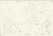
Wiltshire XLII.5 (includes: Milton Lilbourne; Pewsey) - 25 Inch Map
1 : 2500 Topographic maps Ordnance Survey Ordnance Survey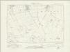
Wiltshire XLII.NW - OS Six-Inch Map
1 : 10560 Topographic maps Ordnance Survey Ordnance Survey
Wiltshire XLII.NW - OS Six-Inch Map
1 : 10560 Topographic maps Ordnance Survey Ordnance Survey
Wiltshire XLII - OS Six-Inch Map
1 : 10560 Topographic maps Ordnance Survey Ordnance Survey
SU15 - OS 1:25,000 Provisional Series Map
1 : 25000 Topographic maps Ordnance Survey Ordnance Survey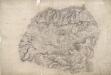
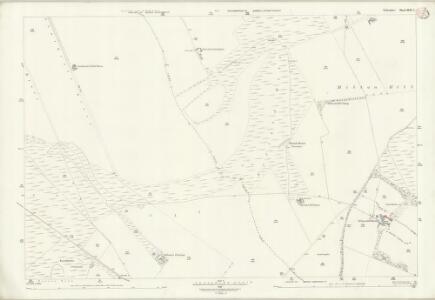
Wilcot
Several orientation points used to plot the survey appear at the edges of this drawing. The draughtsman has recorded the precise layout of the fir plantations at Everly, a chalk pit on Bushton Down, and the Roman road from Bath to Malborough, which is at the top of the drawing. The Kennet and Avon Canal also features. Opened in 1810 to better exploit the resources of the Somerset Coalfields, the canal is contemporary with the survey of this drawing. Extending from Shepherds Shore, a thick grey line is marked 'The Wansdyke'. This is a linear defensive earthwork dating from the 5th century. The area is rich is archaeological sites: Casterely Camp on Black Heath is a large hillfort. The paper is watermarked JAMES WHATMAN TURKEY MILL KENT 1807.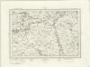
Devizes (Outline) - OS One-Inch Revised New Series
1 : 63360 Topographic maps Ordnance Survey Ordnance Survey
Devizes (Hills) - OS One-Inch Revised New Series
1 : 63360 Topographic maps Ordnance Survey Ordnance Survey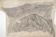
Hungerford
This drawing describes the borders of the counties of Berkshire, Hampshire and Wiltshire. Their boundaries are marked by red pecked lines, as a note at the base of the drawing explains. The draughtsman has detailed the star-shaped path formation of Savernake Forest, a great royal hunting forest, and recorded the Roman road between Marton and Titcombe. Chisbury, an iron-age hillfort, is marked by concentric rings to the right of Savernake Forest, although the recording of archaeological features did not become obligatory until 1816. To the left of Shalbourne, a windmill is shown in elevation.
Salisbury - OS One-Inch Map
1 : 63360 Topographic maps Ordnance Survey Ordnance Survey
Cary's Improved Map of England and Wales
Cary, George, & Cary, John London : G. & J. Cary
An improved map of Wilt Shire
1 Karte : Kupferdruck ; 52 x 68 cm Bowen; Tinney sold by I. Tinney at the Golden Lion in Fleet street
Wiltonia sive comitatvs Wiltoniensis; anglis Wil Shire
1 Karte : Kupferdruck ; 40 x 48 cm Blaeu Joan Blaeu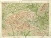
Berkshire, Sheet 29 - Bartholomew's "Half Inch to the Mile Maps" of England & Wales
1 : 126720 Topographic maps Bartholomew, John George John Bartholomew & Co
BERCHERIA | Vernacule | BARK SHIRE.
[Amsterdam : Joan Blaeu]
Wiltonia sive Comitatus Wiltoniensis anglis Wil Shire
1 : 210000 Amstelodami : apud Joannem Janssonium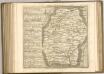

Hantonia sive Sovthantonensis comitatvs vulgo Hant-shire
1 Karte : Kupferdruck ; 40 x 48 cm Blaeu Joan Blaeu
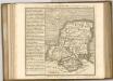
WILTONIAE Comitatus
This is a map of Wiltshire by Christopher Saxton which dates from 1576. It forms part of an atlas that belonged to William Cecil Lord Burghley, Elizabeth I’s Secretary of State. Burghley used this atlas to illustrate domestic matters. This map is actually a proof copy of one which forms part of Christopher Saxton’s Atlas of England and Wales. This atlas was first published as a whole in 1579. It consists of 35 coloured maps depicting the counties of England and Wales. The atlas is of great significance to British cartography as it set a standard of cartographic representation in Britain and the maps remained the basis for English county mapping, with few exceptions, until after 1750. During the reign of Elizabeth I, map use became more common, with many government matters referring to increasingly accurate maps with consistent scales and symbols, made possible by advances in surveying techniques. Illustrating the increasing use of maps in government matters, Lord Burghley, who had been determined to have England and Wales mapped in detail from the 1550s, selected the cartographer Christopher Saxton to produce a detailed and consistent survey of the country. The financier of the project was Thomas Seckford Master of Requests at the Court of Elizabeth I, whose arms appear, along with the royal crest on each map .Lord Burghley has added several place names to the map. This map was engraved by Remigius Hogenbergius, one of a team of seven English and Flemish engravers employed to produce the copper plates for the atlas. Saxton, Christopher Hogenbergius, Remigius
WILTONIA | sive | COMITATVS WILTONI- | ENSIS; Anglis | WIL SHIRE.
[Amsterdam : Joan Blaeu]
Bercheria Vernacule Bark Shire. [Karte], in: Theatrum orbis terrarum, sive, Atlas novus, Bd. 4, S. 186.
1 Karte aus Atlas Blaeu, Joan Blaeu, Willem Janszoon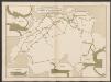
Bercheria Vernacule Barkshire. [Karte], in: Le théâtre du monde, ou, Nouvel atlas contenant les chartes et descriptions de tous les païs de la terre, Bd. 4, S. 164.
1 Karte aus Atlas Blaeu, Willem Janszoon und Blaeu, Joan Blaeu, Willem Janszoon
Bercheria Vernacule Bark Shire. [Karte], in: Theatrum orbis terrarum, sive, Atlas novus, Bd. 4, S. 186.
1 Karte aus Atlas Blaeu, Joan Blaeu, Willem Janszoon
WILTONIAE
This map of Wiltshire is from the 1583 edition of the Saxton atlas of England and Wales. TThis atlas was first published as a whole in 1579. It consists of 35 coloured maps depicting the counties of England and Wales. The atlas is of great significance to British cartography as it set a standard of cartographic representation in Britain and the maps remained the basis for English county mapping, with few exceptions, until after 1750. During the reign of Elizabeth I map use became more common, with many government matters referring to increasingly accurate maps with consistent scales and symbols, made possible by advances in surveying techniques. Illustrating the increasing used of maps in government matters, Lord Burghley, Elizabeth I’s Secretary of State, who had been determined to have England and Wales mapped in detail from the 1550s, selected the cartographer Christopher Saxton to produce a detailed and consistent survey of the country. The financier of the project was Thomas Seckford Master of Requests at the Court of Elizabeth I, whose arms appear, along with the royal crest, on each map. Saxton’s name appears in the decorative scale bar as does the name of the engraver of this map, Remigius Hogenberg ,one of seven English and Flemish engravers employed to produced the copper plates for the atlas. Relief, in the form of uniform rounded representations of hills, is the main topographical feature presented in the maps. Rather than provide a scientific representation of relative relief these give a general impression of the lie of the land. Settlements and notable buildings are also recorded pictorially; a small building with a spire represents a village, while more important towns are indicated by groups of buildings. Here Stonehenge is marked by a pictorial representation and named The Stonadge’. Saxton, Christopher Ryther, Augustine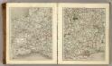
Sheets 13-14. (Cary's England, Wales, and Scotland).
1 : 360000 Cary, John, ca. 1754-1835
A new improved map of Hampshire
1 Karte : Kupferdruck ; 51 x 67 cm Kitchin; Hinton sold by I. Hinton at the Kings Arms in St. Pauls Church Yard