Maps of Wiltshire
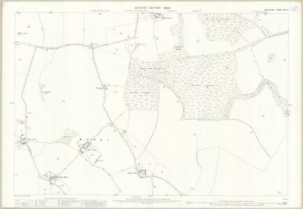
Wiltshire XXX.9 (includes: Froxfield; Ramsbury) - 25 Inch Map
1 : 2500 Topographic maps Ordnance Survey Ordnance Survey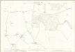
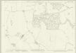
Wiltshire XXX.9 (includes: Froxfield; Ramsbury) - 25 Inch Map
1 : 2500 Topographic maps Ordnance Survey Ordnance Survey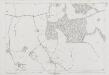
Wiltshire XXX.9 (includes: Froxfield; Ramsbury) - 25 Inch Map
1 : 2500 Topographic maps Ordnance Survey Ordnance Survey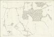
Wiltshire XXX.9 (includes: Froxfield; Ramsbury) - 25 Inch Map
1 : 2500 Topographic maps Ordnance Survey Ordnance Survey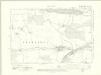
Berkshire XXXIII.SW - OS Six-Inch Map
1 : 10560 Topographic maps Ordnance Survey Ordnance Survey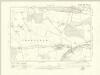
Berkshire XXXIII.SW - OS Six-Inch Map
1 : 10560 Topographic maps Ordnance Survey Ordnance Survey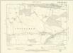
Berkshire XXXIII.SW - OS Six-Inch Map
1 : 10560 Topographic maps Ordnance Survey Ordnance Survey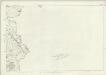
Wiltshire XXX - OS Six-Inch Map
1 : 10560 Topographic maps Ordnance Survey Ordnance Survey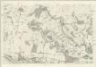
Berkshire XXXIII - OS Six-Inch Map
1 : 10560 Topographic maps Ordnance Survey Ordnance Survey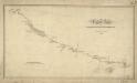
The Turnpike Road From Marlborough To Hungerford
1 : 31680 .Records from the Ordnance Survey Letter Book suggest that Edmund Crocker surveyed the turnpike road from Hungerford to Marlborough and William Stanley, draughtsman, made the drawing. The road is coloured yellow ochre and one side is thickened to indicate its importance. Notes of mileage in ink figures appear alongside the road. The close attention given to communication routes highlights the military emphasis of these studies. Stanley, William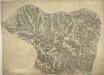
Lambourn
1 : 31680 Author of this drawing, William Stanley was listed as a 'first class' military draughtsman and surveyor at the Tower of London Drawing Room. The top boundary of this section of the Berkshire Downs follows an ancient grass track, the Ridge Way. Elaborate hill shading describing relief and the attention given to communications routes highlight the military emphasis of these studies. Archaeological details are documented even though this did not become obligatory until 1816. Pencil rays intersecting across the manuscript are evidence of angular measurements taken by the surveyor between fixed points. Stanley, William
Hungerford (Hills) - OS One-Inch Revised New Series
1 : 63360 Topographic maps Ordnance Survey Ordnance Survey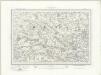
Hungerford (Outline) - OS One-Inch Revised New Series
1 : 63360 Topographic maps Ordnance Survey Ordnance Survey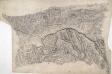
Hungerford
This drawing describes the borders of the counties of Berkshire, Hampshire and Wiltshire. Their boundaries are marked by red pecked lines, as a note at the base of the drawing explains. The draughtsman has detailed the star-shaped path formation of Savernake Forest, a great royal hunting forest, and recorded the Roman road between Marton and Titcombe. Chisbury, an iron-age hillfort, is marked by concentric rings to the right of Savernake Forest, although the recording of archaeological features did not become obligatory until 1816. To the left of Shalbourne, a windmill is shown in elevation.
Swindon
1 : 31680 The author of this drawing, William Stanley, was listed as a 'first class' Military draughtsman and surveyor at the Tower of London Drawing Room. His elaborate hill shading technique for describing relief and the attention he pays to communications routes reinforce the military emphasis of these maps. Archaeological details are documented even though this did not become obligatory until 1816. The iron-age hillfort at Barbury Castle is described, along with numerous barrows and earthworks. Stanley, William
Swindon - OS One-Inch Map
1 : 63360 Topographic maps Ordnance Survey Ordnance Survey
Oxford and Newbury - OS One-Inch Map
1 : 63360 Topographic maps Ordnance Survey Ordnance Survey
Hamp Shire ; Berk Shire ; Wilt Shire
1 : 330000 Berkshire (Anglie) Moll, Herman
A map of the county of Berks
1 Karte : Kupferdruck ; 43 x 66 cm Rocque; Rocque published according to act of parliament by Mary Ann Rocque near old Round Court in the Strand
An accurate map of Berkshire
1 Karte : Kupferdruck ; 52 x 68 cm Bowen; Tinney; Bowles; Sayer; Bowles; Bowles sold by I. Bowles and son in Cornhill T. Bowles in St. Pauls church yard I. Tinney at the Golden Lion and R. Sayer at the Golden Buck in Fleet street
Bercheria vernacule Bark Shire
1 Karte : Kupferdruck ; 37 x 48 cm Blaeu Joan Blaeu
Cary's Improved Map of England and Wales
Cary, George, & Cary, John London : G. & J. Cary
A new improved map of Oxfordshire
1 Karte : Kupferdruck ; 69 x 51 cm Kitchin; Hinton sold by J. Hinton at the Kings Arms in St. Pauls Church Yard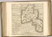

An improved map of Wilt Shire
1 Karte : Kupferdruck ; 52 x 68 cm Bowen; Tinney sold by I. Tinney at the Golden Lion in Fleet street
Wiltonia sive comitatvs Wiltoniensis; anglis Wil Shire
1 Karte : Kupferdruck ; 40 x 48 cm Blaeu Joan Blaeu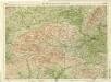
Berkshire, Sheet 29 - Bartholomew's "Half Inch to the Mile Maps" of England & Wales
1 : 126720 Topographic maps Bartholomew, John George John Bartholomew & Co
BERCHERIA | Vernacule | BARK SHIRE.
[Amsterdam : Joan Blaeu]