Maps of Cranborne
Dorset XVI.6 (includes: Cranborne; Edmondsham; Wimborne St Giles) - 25 Inch Map
1 : 2500 Topographic maps Ordnance Survey Ordnance Survey
Dorset XVI.6 (includes: Cranborne; Edmondsham; Wimborne St Giles) - 25 Inch Map
1 : 2500 Topographic maps Ordnance Survey Ordnance Survey
Dorset XVI.NW - OS Six-Inch Map
1 : 10560 Topographic maps Ordnance Survey Ordnance Survey
Dorset XVI.NW - OS Six-Inch Map
1 : 10560 Topographic maps Ordnance Survey Ordnance Survey
Hampshire & Isle of Wight LXIIA.NE - OS Six-Inch Map
1 : 10560 Topographic maps Ordnance Survey Ordnance Survey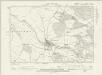
Hampshire & Isle of Wight LXIIA.NE - OS Six-Inch Map
1 : 10560 Topographic maps Ordnance Survey Ordnance Survey
Wiltshire LXXIX.NE - OS Six-Inch Map
1 : 10560 Topographic maps Ordnance Survey Ordnance Survey
SU01 - OS 1:25,000 Provisional Series Map
1 : 25000 Topographic maps Ordnance Survey Ordnance Survey
Ringwood (Hills) - OS One-Inch Revised New Series
1 : 63360 Topographic maps Ordnance Survey Ordnance Survey
Ringwood (Outline) - OS One-Inch Revised New Series
1 : 63360 Topographic maps Ordnance Survey Ordnance Survey
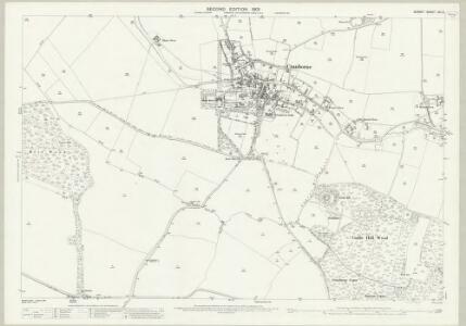
Cranborne
This drawing represents the relative relief of the landscape by light shading and interlining in pencil. Parallel pecked lines indicate paths across open land. Achling Ditch, a Roman road, runs diagonally across the drawing. To the left of the road is Blandford Race Ground and Telegraph. As well as being a racecourse until the end of the 19th century, Blandford was used as a military training ground by local volunteers from the 18th century onwards. In 1806, a Royal Navy Shutter Telegraph Station was built near the racecourse. The signal station, on the London to Plymouth route, was closed after the Napoleonic War. In the lower section of the map, concentric rings depict the iron-age hillfort of Badbury Rings.
Dorset Shire, 3
2 Blätter : 109 x 45 cm s.n.
Bournemouth - OS One-Inch Map
1 : 63360 Topographic maps Ordnance Survey Ordnance Survey
Salisbury - OS One-Inch Map
1 : 63360 Topographic maps Ordnance Survey Ordnance Survey
Cary's Improved Map of England and Wales
Cary, George, & Cary, John London : G. & J. Cary
Comitatus Dorcestria, sive Dorsettia ; vulgo anglice Dorset Shire
1 : 145000
Comitatus Dorcestria vulgo anglice Dorset Shire
1 : 170000 Amstelodami : apud Joannem Janssonium
New Forrest & Isle of Wight, Sheet 33 - Bartholomew's "Half Inch to the Mile Maps" of England & Wales
1 : 126720 Topographic maps Bartholomew, John George John Bartholomew & Co
Wiltonia sive Comitatus Wiltoniensis anglis Wil Shire
1 : 210000 Amstelodami : apud Joannem Janssonium
An accurate map of Dorset Shire divided into hundreds
1 : 222000
Map of Dorsetshire
This map comes from the Abbott's Illustrated Counties series of county guides: Dorsetshire, its history, antiquities, places of interest, etc a complete, concise and exhaustive story of Dorset from the earliest times to the present day' The Guide Printing & Publishing Co.
WILTONIAE Comitatus
This is a map of Wiltshire by Christopher Saxton which dates from 1576. It forms part of an atlas that belonged to William Cecil Lord Burghley, Elizabeth I’s Secretary of State. Burghley used this atlas to illustrate domestic matters. This map is actually a proof copy of one which forms part of Christopher Saxton’s Atlas of England and Wales. This atlas was first published as a whole in 1579. It consists of 35 coloured maps depicting the counties of England and Wales. The atlas is of great significance to British cartography as it set a standard of cartographic representation in Britain and the maps remained the basis for English county mapping, with few exceptions, until after 1750. During the reign of Elizabeth I, map use became more common, with many government matters referring to increasingly accurate maps with consistent scales and symbols, made possible by advances in surveying techniques. Illustrating the increasing use of maps in government matters, Lord Burghley, who had been determined to have England and Wales mapped in detail from the 1550s, selected the cartographer Christopher Saxton to produce a detailed and consistent survey of the country. The financier of the project was Thomas Seckford Master of Requests at the Court of Elizabeth I, whose arms appear, along with the royal crest on each map .Lord Burghley has added several place names to the map. This map was engraved by Remigius Hogenbergius, one of a team of seven English and Flemish engravers employed to produce the copper plates for the atlas. Saxton, Christopher Hogenbergius, Remigius
COMITATVS | DORCESTRIA, | sive | DORSETTIA; | Vulgo Anglice | DORSET SHIRE.
[Amsterdam : Joan Blaeu]
DORCESTRIAE Comitatus
This is a map of Dorset by Christopher Saxton, datingfrom 1575. It forms part of an atlas that belonged to William Cecil Lord Burghley, Elizabeth I’s Secretary of State. Burghley used this atlas to illustrate domestic matters. This map is actually a proof copy of one which forms part of Christopher Saxton’s Atlas of England and Wales. This atlas was first published as a whole in 1579. It consists of 35 coloured maps depicting the counties of England and Wales. The atlas is of great significance to British cartography as it set a standard of cartographic representation in Britain and the maps remained the basis for English county mapping, with few exceptions, until after 1750. During the reign of Elizabeth I map use became more common, with many government matters referring to increasingly accurate maps with consistent scales and symbols, made possible by advances in surveying techniques. Illustrating the increasing use of maps in government matters, Lord Burghley, who had been determined to have England and Wales mapped in detail from the 1550s, selected the cartographer Christopher Saxton to produce a detailed and consistent survey of the country. The financier of the project was Thomas Seckford, Master of Requests at the Court of Elizabeth I, whose arms appear, along with the royal crest, on each map. Lord Burghley added several place names. In the lower margin there are notes concerning 'Dangerous places for landing of men in the county'. These notes were probably written by an assistant of Lord Burghley and show the concern felt about the south coasts vulnerability to invasion. Due to the presence of a Protestant Queen in the form of Elizabeth I, England was under threat from a catholic crusade from Philip II of Spain. This threat culminated in the events of the Spanish Armada in 1588. Saxton, Christopher William Cecil, Lord Burghley
An accurate map of Dorset Shire, divided into its hundreds
1 : 180000
WILTONIA | sive | COMITATVS WILTONI- | ENSIS; Anglis | WIL SHIRE.
[Amsterdam : Joan Blaeu]
DORCESTRIAE
This map of Dorset is from the 1583 edition of the Saxton atlas of England and Wales. This atlas was first published as a whole in 1579. It consists of 35 coloured maps depicting the counties of England and Wales. The atlas is of great significance to British cartography as it set a standard of cartographic representation in Britain and the maps remained the basis for English county mapping, with few exceptions, until after 1750. During the reign of Elizabeth I map use became more common, with many government matters referring to increasingly accurate maps with consistent scales and symbols, made possible by advances in surveying techniques. Illustrating the increasing used of maps in government matters, Lord Burghley, Elizabeth I’s Secretary of State, who had been determined to have England and Wales mapped in detail from the 1550s, selected the cartographer Christopher Saxton to produce a detailed and consistent survey of the country. The financier of the project was Thomas Seckford Master of Requests at the Court of Elizabeth I, whose arms appear, along with the royal crest, on each map. Here the strap work cartouche is mounted by the Elizabethan coat of arms. The Seckford arms of appear at the bottom of the map, adjacent to the decorative scale bar which houses Saxton’s name. The adjacent counties are named but lack any internal detail, recording only the path of rivers that cross county boundaries. Relief, in the form of uniform rounded representations of hills, is the main topographical feature presented in the maps. Rather than provide a scientific representation of relative relief these give a general impression of the lie of the land. Settlements and notable buildings are also recorded pictorially; a small building with a spire represents a village, while more important towns are indicated by groups of buildings. Here Portland castle is marked by a castle symbol of two connected towers. Rivers, streams, parks and woodlands are also depicted carefully. Woods are shown by small tree-symbols, with clusters representing forests, and parklands enclosed with ring fences. Great decorative effect is provided by the detailed images of ships in the stippled sea. Saxton, Christopher Ryther, Augustine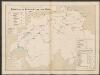
Comitatus Dorcestria, sive Dorsettia; Vulgo Anglice Dorset Shire. [Karte], in: Le théâtre du monde, ou, Nouvel atlas contenant les chartes et descriptions de tous les païs de la terre, Bd. 4, S. 127.
1 Karte aus Atlas Blaeu, Willem Janszoon und Blaeu, Joan Blaeu, Willem Janszoon
Comitatus Dorcestria, sive Dorsettia; Vulgo Anglice Dorset Shire. [Karte] , in: Theatrum orbis terrarum, sive, Atlas novus, Bd. 4, S. 143.
1 Karte aus Atlas Blaeu, Joan Blaeu, Willem Janszoon