Maps of Milford-on-Sea
Hampshire and Isle of Wight LXXXVIII.13 (includes: Lymington) - 25 Inch Map
1 : 2500 Topographic maps Ordnance Survey Ordnance Survey
Hampshire and Isle of Wight LXXXVIII.13 (includes: Lymington) - 25 Inch Map
1 : 2500 Topographic maps Ordnance Survey Ordnance Survey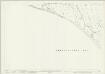
Hampshire and Isle of Wight LXXXVIII.13 (includes: Lymington) - 25 Inch Map
1 : 2500 Topographic maps Ordnance Survey Ordnance Survey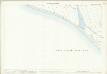
Hampshire and Isle of Wight LXXXVIII.13 (includes: Lymington) - 25 Inch Map
1 : 2500 Topographic maps Ordnance Survey Ordnance Survey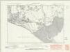
Hampshire & Isle of Wight LXXXVIII.SW - OS Six-Inch Map
1 : 10560 Topographic maps Ordnance Survey Ordnance Survey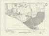
Hampshire & Isle of Wight LXXXVIII.SW - OS Six-Inch Map
1 : 10560 Topographic maps Ordnance Survey Ordnance Survey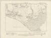
Hampshire & Isle of Wight LXXXVIII.SW - OS Six-Inch Map
1 : 10560 Topographic maps Ordnance Survey Ordnance Survey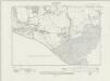
Hampshire & Isle of Wight LXXXVIII.SW - OS Six-Inch Map
1 : 10560 Topographic maps Ordnance Survey Ordnance Survey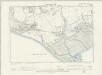
Hampshire & Isle of Wight LXXXVIII.SW - OS Six-Inch Map
1 : 10560 Topographic maps Ordnance Survey Ordnance Survey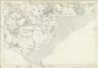
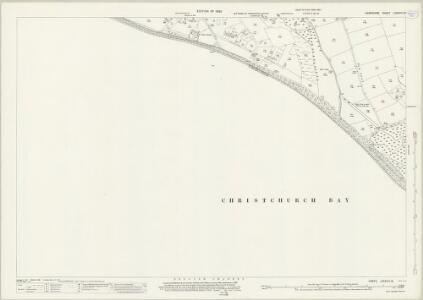
Hampshire & Isle of Wight LXXXVIII - OS Six-Inch Map
1 : 10560 Topographic maps Ordnance Survey Ordnance Survey
Christchurch
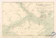
This coastal plan is drawn to a scale of 3 inches to the mile, unlike most inland drawings, which are two inches to the mile. The larger scale reflects greater concern for the vulnerability of this area. The Solent gives access to the ports of Portsmouth and Southampton, making it a particularly attractive avenue for naval invasion. Hurst Castle is marked in black and red at the narrow entrance to the Solent. Built by Henry VIII as part of a defensive chain of fortresses, it is sited where the ebb and flow of the tides create particularly strong currents, providing an excellent natural defence against would-be invaders. The castle was modernised during the Napoleonic Wars. To the right of the castle, salt marshes extend towards Lymington. The saltworks, shown by blue squares, once supplied most of the west of England. A signal house is noted on Christchurch Head.
Lymington (Hills) - OS One-Inch Revised New Series
1 : 63360 Topographic maps Ordnance Survey Ordnance Survey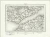
Lymington (Outline) - OS One-Inch Revised New Series
1 : 63360 Topographic maps Ordnance Survey Ordnance Survey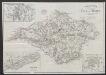
Bacon's new map of the Isle of Wight
1 : 63360 G.W. Bacon & Co.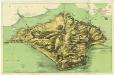
Wight[The Isle of]
Fowles, A.W. Ventnor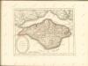
V anglickém průlivu
O anglickém průlivu
1 : 290000 Isle of Wight (Anglie) Hanf, Norbert Kořenský, Josef J. Otta
Wight Vectis olim [Karte], in: Gerardi Mercatoris Atlas, sive, Cosmographicae meditationes de fabrica mundi et fabricati figura, S. 130.
1 Karte aus Atlas Mercator, Gerhard Montanus, Petrus
VECTIS | INSVLA. | Anglice | THE ISLE OF | WIGHT.
[Amsterdam : Joan Blaeu]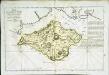
Essai d'une isle de Wight
1 Karte : Kupferdruck ; 30 x 47 cm Le Rouge; Taylor chez le Rouge rue des g.ds Augustins
Vectis Insula. Anglice The Isle Of Wight. [Karte], in: Theatrum orbis terrarum, sive, Atlas novus, Bd. 4, S. 183.
1 Karte aus Atlas Blaeu, Joan Blaeu, Willem Janszoon
Vectis Insula. Anglice The Isle Of Wight. [Karte], in: Theatrum orbis terrarum, sive, Atlas novus, Bd. 4, S. 183.
1 Karte aus Atlas Blaeu, Joan Blaeu, Willem Janszoon
Vectis Insula. Anglice The Isle Of Wight. [Karte], in: Le théâtre du monde, ou, Nouvel atlas contenant les chartes et descriptions de tous les païs de la terre, Bd. 4, S. 161.
1 Karte aus Atlas Blaeu, Willem Janszoon und Blaeu, Joan Blaeu, Willem Janszoon
Map of Hampshire, including the Isle of Wight, 5
1 Blatt : 52 x 68 cm s.n.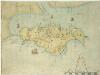
Description of the Isle of Wight
This map of the Isle of Wight dates from around 1600. It is titled on the reverse "Description of the Isle of Wight". A scale bar is included with the motif of dividers, stating ‘Scala Miliaria’, revealing that the map is drawn on a scale of half an inch to one mile. We can not be certain of the identity of the cartographer of this map but it may be one which is thought to have been produced by William White, which was then augmented and published by John Speed in his Theatre of the Empire of Great Britaine. Both this map and the Speed map exaggerate the width of waterways, the depth of bays and prominence of headlands, in a similar way. Such exaggerations suggest that this map was not the result of survey and was drawn by eye. The beacon network on the island is shown by pictorial representations of individual beacons. The Needles are represented by three squat triangles and labelled ‘The nedles’. The period during which this map was produced saw England at war with Spain. The emphasis on the beacon network suggests that the map is concerned with defence in this climate of unease. Since the accession of the Protestant Elizabeth I to the English throne in 1558 Anglo-Spanish relationship had deteriorated. The continued English raids on Spanish colonial interests and England’s support of the Protestant rebellion in the Spanish ruled Netherlands had induced the Catholic Philip II to plan an invasion of England. Although the Spanish were dramatically defeated by the English in 1588, England remained at war with Spain for many years and further attempts to invade were made by Philip of Spain with the dispersal of the ‘second Armada’ in October 1596 and the assembly of the ‘third Armada’ in the following spring. White, William
Wight Vectis olim [Karte], in: Atlas, sive, Cosmographicae meditationes de fabrica mundi et fabricati figura, S. 125.
1 Karte aus Atlas Mercator, Gerhard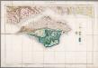
Isle of Wight / Geological Survey of England and Wales
1 : 63360 Annotatie: New Series, sheets 330, 331, 344, 345 Geological Survey of England and Wales Southampton : Ordnance Survey of England
Isle of Wight
This is a manuscript map of the Isle of Wight. It forms part of an atlas that belonged to William Cecil Lord Burghley, Elizabeth I’s Secretary of State. Burghley used this atlas to illustrate domestic matters. It is thought to be by John Rudd, the man to whom Christopher Saxton was an apprentice to in 1570. John Rudd was Vicar of Dewsbury from 1554 to 1570. Rudd had a keen interest in cartography and had been engaged in the 1550s in making a "platt" of England. In 1561 Rudd was granted leave to travel further to map the country and it is likely that Saxton accompanied him, acquiring his skills for surveying. The map shows the Isle of Wight and the coast of Hampshire. By the end of the reign of Henry VIII this area was one of the most heavily defended areas in Northern Europe, the reason for this being the need to defend the vital navel base of Portsmouth and the access that could be gained to this via the Solent. Portsmouth was provided with defensive structures in the 1520’s, making them one of the earliest artillery defences in Britain. The angular lines of these defences are shown here. The distinguishing feature of this map is that the many fortifications in the area are noted and that the draughtsman has recorded the actual architectural plans of the castles. The trefoil shape of Hurst castle is clearly delineated as is the rectangular and triangular bastioned outline of Southsea castle. Calshot castle is marked on the map as Calsharde’. This fort was vital in that it controlled the entrance to Southampton water and linked defensively with the forts of East and West Cowes, located opposite Calshot on the Isle of Wight on either side of the Medina River, which provides access to the centre of the island. In the centre of the Isle, Carisbrooke castle is shown. The draughtsman has recorded the walled and roughly rectangular shape. Interestingly at St Helen’s a plan of a concentric segmented circular structure is shown. This may be a fortification built sometime between 1539 and 1552 to defend the landing, of which little is now known. [Rudd, John] William Cecil, Lord Burghley