Maps of Hertfordshire
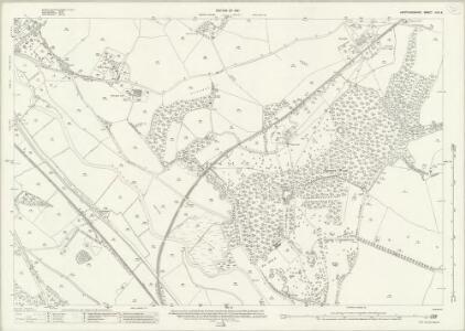
Hertfordshire XXX.9 (includes: Great Amwell; Stanstead Abbots; Ware Rural; Ware Urban) - 25 Inch Map
1 : 2500 Topographic maps Ordnance Survey Ordnance Survey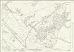
Hertfordshire XXX.9 (includes: Great Amwell; Stanstead Abbots; Ware Rural; Ware Urban) - 25 Inch Map
1 : 2500 Topographic maps Ordnance Survey Ordnance Survey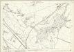
Hertfordshire XXX.9 (includes: Great Amwell; Stanstead Abbots; Ware Rural; Ware Urban) - 25 Inch Map
1 : 2500 Topographic maps Ordnance Survey Ordnance Survey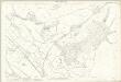
Hertfordshire XXX.9 (includes: Great Amwell; Stanstead Abbots; Ware Rural; Ware Urban) - 25 Inch Map
1 : 2500 Topographic maps Ordnance Survey Ordnance Survey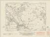
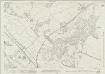
Hertfordshire XXX.SW - OS Six-Inch Map
1 : 10560 Topographic maps Ordnance Survey Ordnance Survey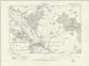
Hertfordshire XXX.SW - OS Six-Inch Map
1 : 10560 Topographic maps Ordnance Survey Ordnance Survey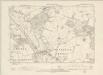
Hertfordshire XXX.SW - OS Six-Inch Map
1 : 10560 Topographic maps Ordnance Survey Ordnance Survey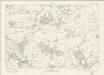
Essex nXLI - OS Six-Inch Map
1 : 10560 Topographic maps Ordnance Survey Ordnance Survey
Hertfordshire XXX - OS Six-Inch Map
1 : 10560 Topographic maps Ordnance Survey Ordnance Survey
TL31 - OS 1:25,000 Provisional Series Map
1 : 25000 Topographic maps Ordnance Survey Ordnance Survey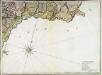
A topographical map of Hartford-Shire, 9
1 Blatt : 53 x 72 cm A. Dury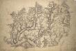
Ware 2
1 : 31680 .Much consideration is given in this map to the detailed representation of trees., Woodland could provide either hindrance or cover for a regiment on the move., Trees are drawn with small vertical stems and a shadow at the base., Planted avenues are depicted in this fashion at Ware Park, above Hartford, and Eastwich Hall, at the bottom of the map., A pattern of open dotting depicts the untilled agricultural land dominating the valleys of the Rivers Rib and Ash.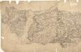
Epping
Pencil lines radiating from trigonometrical stations cover this drawing. They show the angles used for measuring distances and plotting topographical features. To the left of the map on Chestnut Common, the word 'flag' denotes the site of such a station. Hoddesden Park Wood and surrounding woodland are shown by individual trees with a line at the base, indicating shadow. This laborious technique was often replaced by a more generalised, stippled representation of treetops. The Lee River, running from Standstead at the top of this drawing, branches to form a canal leading down to the Powder Mills, which manufactured Gun Powder for shipping to London. Locks on the canal are shown in red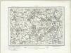
Hertford (Outline) - OS One-Inch Revised New Series
1 : 63360 Topographic maps Ordnance Survey Ordnance Survey
Hertford (Hills) - OS One-Inch Revised New Series
1 : 63360 Topographic maps Ordnance Survey Ordnance Survey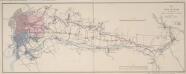
Map of the New River from its Source near the Town of Ware to London
Map of the course of the New River, a man made water course which has supplied London with fresh water from Hertfordshire since 1613. Commissioned by the House of Commons, the map features title and scale bar at top right and key to colour at bottom right. Telford, Thomas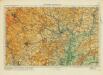
Hertford& St Albans
Ordnance Survey
London passenger transport map
Ordnance Survey
Ordnance Survey of England and Wales (Sheet 7), South Wales
Ordnance Survey, Great Britain
Bedford and Luton - OS One-Inch Map
1 : 63360 Topographic maps Ordnance Survey Ordnance Survey
London N.E. - OS One-Inch Map
1 : 63360 Topographic maps Ordnance Survey Ordnance Survey
Saffron Walden - OS One-Inch Map
1 : 63360 Topographic maps Ordnance Survey Ordnance Survey
A New and Correct Mapp of Middlesex, Essex and Hertfordshire
Bland, Joseph, Parker, Samuel, Smyth, Payler and Warburton, John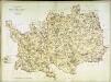
A topographical map of Hartford-Shire
1 Karte : Kupferdruck ; 52 x 70 cm Dury; Andrews Andrew Dury
To the Nobility & Gentry of Essex
Pask, Joseph Robert Morden
A new improved map of Hartford Shire
1 Karte : Kupferdruck ; 51 x 64 cm Kitchin; Hinton; Walker sold by I. Hinton at the Kings Arms in St. Pauls Church yard
Map showing the general Boundaries of the GENERAL POST DELIVERY; of the FOREIGN DELIVERY; of the Town Delivery of the Two penny Post Department; and of the COUNTRY DELIVERY
This map of the area round London was produced by order of the House of Commons for the 21st report of the Commissioners of Revenue Inquiry. The map's title is at top right with areas of various postal delivery services highlighted in colour. Basire, James
HARTFORDIAE COMITATUS f.34
This is a map of Herefordshire by Christopher Saxton which dates from 1577. It forms part of an atlas that belonged to William Cecil Lord Burghley, Elizabeth I’s Secretary of State. Burghley used this atlas to illustrate domestic matters. This map is actually a proof copy of one which forms part of Christopher Saxton’s Atlas of England and Wales. This atlas was first published as a whole in 1579. It consists of 35 coloured maps depicting the counties of England and Wales. The atlas is of great significance to British cartography as it set a standard of cartographic representation in Britain and the maps remained the basis for English county mapping, with few exceptions, until after 1750. During the reign of Elizabeth I, map use became more common, with many government matters referring to increasingly accurate maps with consistent scales and symbols, made possible by advances in surveying techniques. Illustrating the increasing use of maps in government matters, Lord Burghley, who had been determined to have England and Wales mapped in detail from the 1550s, selected the cartographer Christopher Saxton to produce a detailed and consistent survey of the country. The financier of the project was Thomas Seckford Master of Requests at the Court of Elizabeth I, whose arms appear, along with the royal crest, on each map. Lord Burghley has added several place names to the map. This map was engraved by Nicholaus Reynoldus one of a team of seven English and Flemish engravers employed to produced the copper plates for the atlas. Saxton, Christopher Reynoldus, Nicholaus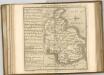

Delineatio ac finitima regio Magnæ Brittaniæ metropoleos Londini
1 Karte : Kupferdruck ; 48 x 57 cm Lotter Tobias Konrad Lotter