Maps of South Cambridgeshire
Hertfordshire V.15 (includes: Barley; Great Chishill; Little Chishill) - 25 Inch Map
1 : 2500 Topographic maps Ordnance Survey Ordnance Survey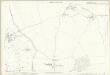
Hertfordshire V.15 (includes: Barley; Great Chishill; Little Chishill) - 25 Inch Map
1 : 2500 Topographic maps Ordnance Survey Ordnance Survey
Hertfordshire V.15 (includes: Barley; Great Chishill; Little Chishill) - 25 Inch Map
1 : 2500 Topographic maps Ordnance Survey Ordnance Survey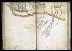
SURVEYS AND PERAMBULATION, WITH PLANS, BY JOHN NORDEN, of the manors of Mincingbury, Abbotsbury and Hoares, in Barley, co. Hertf. made for Sir John Spencer, Lord of the Manors; 1603. f. 31
This plan is from a book containing a survey of the manors of Mincingbury, Abbotsbury and Hoares, in Barley, Hertfordshire. The survey consists of a written survey and ten plans by John Norden, of which this is one. On folio 46 of the survey it is stated that the survey took place in September and October 1603. The plans are the result of a survey conducted on foot. The observance of field boundaries is the primary interest, the names of land owners are recorded in each case. The survey was conducted for Sir John Spencer, Lord of the Manors at this date. John Norden is best known for his work 'Speculum Britainiae', literally a 'Mirror of Britain', which in its attempt to include the road names and town plans, lacking on many county maps of the period, was a direct ancestor of the modern A-Z. As well as producing several county maps in the 1590’s, Norden worked as a land surveyor producing surveys for landowners such as Spencer. This survey exemplifies the principles laid down by Norden in the third book of his Surveyor's Dialogue. This plan, one of ten in the survey, is linked to its neighbours by marginal letters and figures. There is no indication of scale, which, however, appears to be about 18-19 in. to the mile. The maps are oriented with north-east at the top. Norden, John
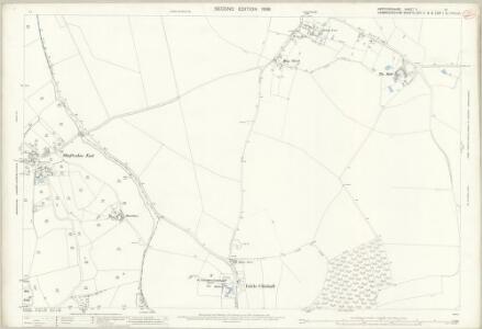
Cambridgeshire LXIIA.8 (includes: Barkway; Barley; Great Chishill; Little Chishill; Nuthampstead) - 25 Inch Map
1 : 2500 Topographic maps Ordnance Survey Ordnance Survey
Essex (1st Ed/Rev 1862-96) VII.8 (includes: Barkway; Barley; Little Chishill; Nuthampstead) - 25 Inch Map
1 : 2500 Topographic maps Ordnance Survey Ordnance Survey
Cambridgeshire LXIIA.4 (includes: Barley; Great Chishill; Little Chishill) - 25 Inch Map
1 : 2500 Topographic maps Ordnance Survey Ordnance Survey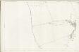
Essex (1st Ed/Rev 1862-96) VII.4 (includes: Barley; Great Chishill; Little Chishill) - 25 Inch Map
1 : 2500 Topographic maps Ordnance Survey Ordnance Survey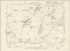
Hertfordshire V.SE - OS Six-Inch Map
1 : 10560 Topographic maps Ordnance Survey Ordnance Survey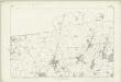
Hertfordshire V - OS Six-Inch Map
1 : 10560 Topographic maps Ordnance Survey Ordnance Survey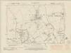
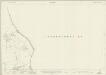
Cambridgeshire LXIIA.NE - OS Six-Inch Map
1 : 10560 Topographic maps Ordnance Survey Ordnance Survey
Cambridgeshire LXIIA.NE - OS Six-Inch Map
1 : 10560 Topographic maps Ordnance Survey Ordnance Survey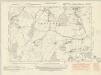
Cambridgeshire LXIIB.NW - OS Six-Inch Map
1 : 10560 Topographic maps Ordnance Survey Ordnance Survey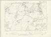
Essex VIII.NW - OS Six-Inch Map
1 : 10560 Topographic maps Ordnance Survey Ordnance Survey
Cambridgeshire LXIIB.NW - OS Six-Inch Map
1 : 10560 Topographic maps Ordnance Survey Ordnance Survey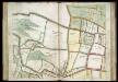
SURVEYS AND PERAMBULATION, WITH PLANS, BY JOHN NORDEN, of the manors of Mincingbury, Abbotsbury and Hoares, in Barley, co. Hertf. made for Sir John Spencer, Lord of the Manors; 1603. f. 29
This plan is from a book containing a survey of the manors of Mincingbury, Abbotsbury and Hoares, in Barley, Hertfordshire. The survey consists of a written survey and ten plans by John Norden, of which this is one. On folio 46 of the survey it is stated that the survey took place in September and October 1603. The plans are the result of a survey conducted on foot. The observance of field boundaries is the primary interest, the names of land owners are recorded in each case. The survey was conducted for Sir John Spencer, Lord of the Manors at this date. John Norden is best known for his work 'Speculum Britainiae', literally a 'Mirror of Britain', which in its attempt to include the road names and town plans, lacking on many county maps of the period, was a direct ancestor of the modern A-Z. As well as producing several county maps in the 1590’s, Norden worked as a land surveyor producing surveys for landowners such as Spencer. This survey exemplifies the principles laid down by Norden in the third book of his Surveyor's Dialogue. This plan, one of ten in the survey, is linked to its neighbours by marginal letters and figures. There is no indication of scale, which, however, appears to be about 18-19 in. to the mile. The maps are oriented with north-east at the top. Norden, John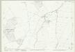
Cambridgeshire LXIIB.5 (includes: Chrishall; Great Chishill; Little Chishill) - 25 Inch Map
1 : 2500 Topographic maps Ordnance Survey Ordnance Survey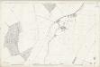
Essex (1st Ed/Rev 1862-96) VIII.5 (includes: Chrishall; Great Chishill) - 25 Inch Map
1 : 2500 Topographic maps Ordnance Survey Ordnance Survey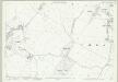
Cambridgeshire LXIIB.1 (includes: Chrishall; Great Chishill; Heydon; Little Chishill) - 25 Inch Map
1 : 2500 Topographic maps Ordnance Survey Ordnance Survey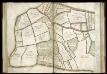
SURVEYS AND PERAMBULATION, WITH PLANS, BY JOHN NORDEN, of the manors of Mincingbury, Abbotsbury and Hoares, in Barley, co. Hertf. made for Sir John Spencer, Lord of the Manors; 1603. f. 27
This plan is from a book containing a survey of the manors of Mincingbury, Abbotsbury and Hoares, in Barley, Hertfordshire. The survey consists of a written survey and ten plans by John Norden, of which this is one. On folio 46 of the survey it is stated that the survey took place in September and October 1603. The plans are the result of a survey conducted on foot. The observance of field boundaries is the primary interest, the names of land owners are recorded in each case. The survey was conducted for Sir John Spencer, Lord of the Manors at this date. John Norden is best known for his work 'Speculum Britainiae', literally a 'Mirror of Britain', which in its attempt to include the road names and town plans, lacking on many county maps of the period, was a direct ancestor of the modern A-Z. As well as producing several county maps in the 1590’s, Norden worked as a land surveyor producing surveys for landowners such as Spencer. This survey exemplifies the principles laid down by Norden in the third book of his Surveyor's Dialogue. This plan, one of ten in the survey, is linked to its neighbours by marginal letters and figures. There is no indication of scale, which, however, appears to be about 18-19 in. to the mile. The maps are oriented with north-east at the top. Norden, John
TL43 - OS 1:25,000 Provisional Series Map
1 : 25000 Topographic maps Ordnance Survey Ordnance Survey
Anstey
1 : 31680 .This plan details the borders of Cambridgeshire, Essex and Hertfordshire. The close attention given to communication routes highlights the military emphasis of the Ordnance Survey. The River Cam is visible towards the right of the map, running from Ducksworth to Newport. Verron
Saffron Walden (Hills) - OS One-Inch Revised New Series
1 : 63360 Topographic maps Ordnance Survey Ordnance Survey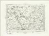
Saffron Walden (Outline) - OS One-Inch Revised New Series
1 : 63360 Topographic maps Ordnance Survey Ordnance Survey
London passenger transport map
Ordnance Survey
Saffron Walden - OS One-Inch Map
1 : 63360 Topographic maps Ordnance Survey Ordnance Survey
A New and Correct Mapp of Middlesex, Essex and Hertfordshire
Bland, Joseph, Parker, Samuel, Smyth, Payler and Warburton, John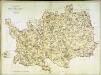
A topographical map of Hartford-Shire
1 Karte : Kupferdruck ; 52 x 70 cm Dury; Andrews Andrew Dury
To the Nobility & Gentry of Essex
Pask, Joseph Robert Morden