Maps of Brentwood
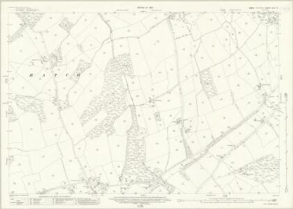
Essex (New Series 1913-) n LXII.13 (includes: Doddinghurst; Kelvedon Hatch; Stondon Massey) - 25 Inch Map
1 : 2500 Topographic maps Ordnance Survey Ordnance Survey
Essex (1st Ed/Rev 1862-96) LIX.6 (includes: Doddinghurst; Kelvedon Hatch; Navestock; Stondon Massey) - 25 Inch Map
1 : 2500 Topographic maps Ordnance Survey Ordnance Survey
Essex (1st Ed/Rev 1862-96) LIX.2 (includes: Kelvedon Hatch; Stondon Massey) - 25 Inch Map
1 : 2500 Topographic maps Ordnance Survey Ordnance Survey
Essex nLXII.SW - OS Six-Inch Map
1 : 10560 Topographic maps Ordnance Survey Ordnance Survey
Essex nLXII.SW - OS Six-Inch Map
1 : 10560 Topographic maps Ordnance Survey Ordnance Survey
Essex LIX - OS Six-Inch Map
1 : 10560 Topographic maps Ordnance Survey Ordnance Survey
Essex LIX.NW - OS Six-Inch Map
1 : 10560 Topographic maps Ordnance Survey Ordnance Survey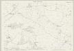
Essex (1st Ed/Rev 1862-96) LIX.7 (includes: Blackmore; Doddinghurst) - 25 Inch Map
1 : 2500 Topographic maps Ordnance Survey Ordnance Survey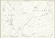
Essex (1st Ed/Rev 1862-96) LIX.3 (includes: Blackmore; High Ongar; Stondon Massey) - 25 Inch Map
1 : 2500 Topographic maps Ordnance Survey Ordnance Survey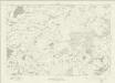
Essex nLXII - OS Six-Inch Map
1 : 10560 Topographic maps Ordnance Survey Ordnance Survey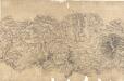
Chelmsford 8
Lines in pencil and red ink radiate from trigonometrical stations within the drawing and from the margins. Chelmsford is the largest settlement in the area. A straight, unmarked Roman road leads out from the city. The fact that the road is coloured yellow suggests it was still considered a major communication route. Three mills are marked on the River Chelmer. Marshland along the riverbanks is indicated by rows of dashes, differentiating it from the surrounding cultivated land. A lake and individual trees in the grounds of Moulsham Hall are recorded, towards the bottom of the landmass, a reminder of the meticulous nature of the Survey.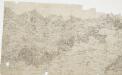
Brentwood, Essex
This drawing covers the settlements and surrounding country of part of Essex. Brentwood is the largest of these settlements. The layout of the town is indicated by red blocks. The straight line of the road leading to the town reveals its Roman origin, although the draughtsman, unusually, does not label it as such. The main communication routes are coloured yellow, conforming to military cartographic standards. The meanderings of the River Crouch are painstakingly plotted, with the surrounding open land represented by dots. Budgen, Charles
Epping (Hills) - OS One-Inch Revised New Series
1 : 63360 Topographic maps Ordnance Survey Ordnance Survey
Epping (Outline) - OS One-Inch Revised New Series
1 : 63360 Topographic maps Ordnance Survey Ordnance Survey
London passenger transport map
Ordnance Survey
Ordnance Survey of England and Wales (Sheet 7), South Wales
Ordnance Survey, Great Britain
London N.E. - OS One-Inch Map
1 : 63360 Topographic maps Ordnance Survey Ordnance Survey
THE ENVIRONS OF LONDON
This map of London and part of the Home Counties was published in Pinnock's 'Guide to Knowledge'. Reduced from an original Ordnance Survey drawing, the map is printed in white on black, with the title in inset table at top centre. Though none of the sheets of the first edition of the Ordnance Survey covered London, part of the metropolitan area was contained in the maps of Middlesex, Essex, Surrey and Kent issued between 1805 and 1822. Archer, Joshua
A New and Correct Mapp of Middlesex, Essex and Hertfordshire
Bland, Joseph, Parker, Samuel, Smyth, Payler and Warburton, John
London.
1 : 126720 John Bartholomew & Co.

An accurate MAP of the Country TWENTY MILES round LONDON. From GRAVESEND to WINDSOR East and West, and from ST. ALBANS to WESTERHAM North and South with the CIRCUIT of the PENNY POST
In the second half of the18th century, the introduction of turnpike roads and the increased coach-traffic in and out of London contributed to the popularity of the maps of the countryside around the capital. The title of this plan runs along the top, with borders divided in degrees of latitude and longitude, county boundaries outlined in colour and the circuit of the Penny Postmarked in red. Before William Dockwra set up the Penny Post in 1680, there was no local delivery of letters in London, except by private courier. Dockwra opened seven sorting offices and hundreds of receiving houses. Letters were delivered to addresses in London for the charge of a penny, paid by the sender. An extra penny was charged for deliveries in the London Country area within ten miles of the city. In 1682, the Post Office took over the running of the service. Cary, John
To the Nobility & Gentry of Essex
Pask, Joseph Robert Morden
Delineatio ac finitima regio Magnae Brittaniae metropoleos Londini
1 : 120000 ad novissimam Normam repraesentata et excusa a T. Conr. Lotter, Augustano Chalcogr. Et Geogr. [Augsburg] : [Tobias Konrad Lotter]
Leigh's new map of the environs of London
1 : 247000 drawn and engraved by Sidy. Hall, 14 Bury St., Bloomsby London : Leigh
Outer London.
1 : 106065 Stanford, Edward
Map showing the general Boundaries of the GENERAL POST DELIVERY; of the FOREIGN DELIVERY; of the Town Delivery of the Two penny Post Department; and of the COUNTRY DELIVERY
This map of the area round London was produced by order of the House of Commons for the 21st report of the Commissioners of Revenue Inquiry. The map's title is at top right with areas of various postal delivery services highlighted in colour. Basire, James
Delineatio ac finitima regio Magnæ Brittaniæ metropoleos Londini
1 Karte : Kupferdruck ; 48 x 57 cm Lotter Tobias Konrad Lotter
Les environs de Londres
1 Karte : Kupferdruck ; 47 x 53 cm chez I. Côvens et C. Mortier