Maps of Hertfordshire
Essex (New Series 1913-) n LI.12 (includes: Great Parndon; Netteswell; North Weald Bassett) - 25 Inch Map
1 : 2500 Topographic maps Ordnance Survey Ordnance Survey
Essex (1st Ed/Rev 1862-96) L.1 (includes: Epping Upland; Great Parndon; North Weald Bassett) - 25 Inch Map
1 : 2500 Topographic maps Ordnance Survey Ordnance Survey
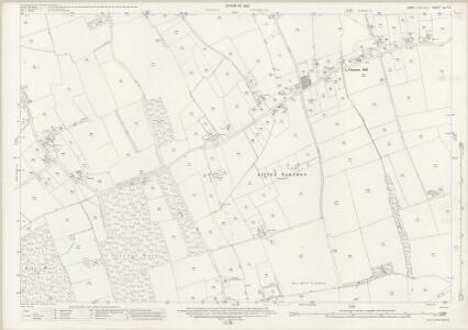
Essex (1st Ed/Rev 1862-96) XLI.13 (includes: Great Parndon; Netteswell) - 25 Inch Map
1 : 2500 Topographic maps Ordnance Survey Ordnance Survey
Essex nLI.SE - OS Six-Inch Map
1 : 10560 Topographic maps Ordnance Survey Ordnance Survey
Essex nLI.SE - OS Six-Inch Map
1 : 10560 Topographic maps Ordnance Survey Ordnance Survey
Essex nLI - OS Six-Inch Map
1 : 10560 Topographic maps Ordnance Survey Ordnance Survey
Hertfordshire XXXVII - OS Six-Inch Map
1 : 10560 Topographic maps Ordnance Survey Ordnance Survey
Essex L.NW - OS Six-Inch Map
1 : 10560 Topographic maps Ordnance Survey Ordnance Survey
Essex XLI.SW - OS Six-Inch Map
1 : 10560 Topographic maps Ordnance Survey Ordnance Survey
Essex (1st Ed/Rev 1862-96) XLI.14 (includes: Harlow; Netteswell; North Weald Bassett) - 25 Inch Map
1 : 2500 Topographic maps Ordnance Survey Ordnance Survey
TL40 - OS 1:25,000 Provisional Series Map
1 : 25000 Topographic maps Ordnance Survey Ordnance Survey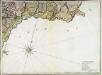
A topographical map of Hartford-Shire, 9
1 Blatt : 53 x 72 cm A. Dury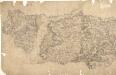
Epping
Pencil lines radiating from trigonometrical stations cover this drawing. They show the angles used for measuring distances and plotting topographical features. To the left of the map on Chestnut Common, the word 'flag' denotes the site of such a station. Hoddesden Park Wood and surrounding woodland are shown by individual trees with a line at the base, indicating shadow. This laborious technique was often replaced by a more generalised, stippled representation of treetops. The Lee River, running from Standstead at the top of this drawing, branches to form a canal leading down to the Powder Mills, which manufactured Gun Powder for shipping to London. Locks on the canal are shown in red
Epping (Hills) - OS One-Inch Revised New Series
1 : 63360 Topographic maps Ordnance Survey Ordnance Survey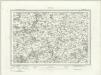
Epping (Outline) - OS One-Inch Revised New Series
1 : 63360 Topographic maps Ordnance Survey Ordnance Survey
London passenger transport map
Ordnance Survey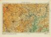
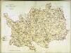
Hertford& St Albans
Ordnance Survey
London passenger transport map
Ordnance Survey
Ordnance Survey of England and Wales (Sheet 7), South Wales
Ordnance Survey, Great Britain
London N.E. - OS One-Inch Map
1 : 63360 Topographic maps Ordnance Survey Ordnance Survey
Saffron Walden - OS One-Inch Map
1 : 63360 Topographic maps Ordnance Survey Ordnance Survey
A New and Correct Mapp of Middlesex, Essex and Hertfordshire
Bland, Joseph, Parker, Samuel, Smyth, Payler and Warburton, John
A topographical map of Hartford-Shire
1 Karte : Kupferdruck ; 52 x 70 cm Dury; Andrews Andrew Dury
An accurate MAP of the Country TWENTY MILES round LONDON. From GRAVESEND to WINDSOR East and West, and from ST. ALBANS to WESTERHAM North and South with the CIRCUIT of the PENNY POST
In the second half of the18th century, the introduction of turnpike roads and the increased coach-traffic in and out of London contributed to the popularity of the maps of the countryside around the capital. The title of this plan runs along the top, with borders divided in degrees of latitude and longitude, county boundaries outlined in colour and the circuit of the Penny Postmarked in red. Before William Dockwra set up the Penny Post in 1680, there was no local delivery of letters in London, except by private courier. Dockwra opened seven sorting offices and hundreds of receiving houses. Letters were delivered to addresses in London for the charge of a penny, paid by the sender. An extra penny was charged for deliveries in the London Country area within ten miles of the city. In 1682, the Post Office took over the running of the service. Cary, John
To the Nobility & Gentry of Essex
Pask, Joseph Robert Morden
Delineatio ac finitima regio Magnae Brittaniae metropoleos Londini
1 : 120000 ad novissimam Normam repraesentata et excusa a T. Conr. Lotter, Augustano Chalcogr. Et Geogr. [Augsburg] : [Tobias Konrad Lotter]
A new improved map of Hartford Shire
1 Karte : Kupferdruck ; 51 x 64 cm Kitchin; Hinton; Walker sold by I. Hinton at the Kings Arms in St. Pauls Church yard
Outer London.
1 : 106065 Stanford, Edward