Maps of London
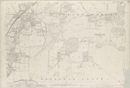
Essex (1st Ed/Rev 1862-96) LXXIII.3 (includes: Leyton; Wanstead) - 25 Inch Map
1 : 2500 Topographic maps Ordnance Survey Ordnance Survey
London IV.73 - OS London Town Plan
1 : 1056 Topographic maps Ordnance Survey Ordnance Survey
London IV.64 - OS London Town Plan
1 : 1056 Topographic maps Ordnance Survey Ordnance Survey
London IV.63 - OS London Town Plan
1 : 1056 Topographic maps Ordnance Survey Ordnance Survey
London IV.83 - OS London Town Plan
1 : 1056 Topographic maps Ordnance Survey Ordnance Survey
Essex LXXIII.NE - OS Six-Inch Map
1 : 10560 Topographic maps Ordnance Survey Ordnance Survey
A Plan of the House, Gardens, Park, and Plantations of Wanstead, the Seat of the Earl of Tylney, by Rocque.
Rocque, John
Essex (New Series 1913-) n LXXVIII.10 (includes: Ilford; Leyton; Wanstead) - 25 Inch Map
1 : 2500 Topographic maps Ordnance Survey Ordnance Survey
Essex (New Series 1913-) n LXXVIII.10 (includes: Ilford; Leyton; Wanstead) - 25 Inch Map
1 : 2500 Topographic maps Ordnance Survey Ordnance Survey
London (Edition of 1894-96) XXIV (includes: Ilford; Leyton; Wanstead) - 25 Inch Map
1 : 2500 Topographic maps Ordnance Survey Ordnance Survey
Essex (New Series 1913-) n LXXVIII.14 (includes: Cann Hall; East Ham; Wanstead; West Ham) - 25 Inch Map
1 : 2500 Topographic maps Ordnance Survey Ordnance Survey
Essex (New Series 1913-) n LXXVIII.14 (includes: Cann Hall; East Ham; Wanstead; West Ham) - 25 Inch Map
1 : 2500 Topographic maps Ordnance Survey Ordnance Survey
London (Edition of 1894-96) XXXIII (includes: Cann Hall; East Ham; Wanstead; West Ham) - 25 Inch Map
1 : 2500 Topographic maps Ordnance Survey Ordnance Survey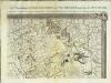
An exact survey of the city's of London Westminster , IV
1 Blatt : 53 x 71 cm John Rocque
London Sheet H - OS Six-Inch Map
1 : 10560 Topographic maps Ordnance Survey Ordnance Survey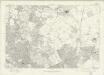
London Sheet H - OS Six-Inch Map
1 : 10560 Topographic maps Ordnance Survey Ordnance Survey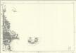
Middlesex XVIII (inset XIII & XXIII) - OS Six-Inch Map
1 : 10560 Topographic maps Ordnance Survey Ordnance Survey
Essex (New Series 1913-) n LXXVIII.9 (includes: Leyton; Walthamstow) - 25 Inch Map
1 : 2500 Topographic maps Ordnance Survey Ordnance Survey
Essex (New Series 1913-) n LXXVIII.9 (includes: Leyton; Walthamstow) - 25 Inch Map
1 : 2500 Topographic maps Ordnance Survey Ordnance Survey
London (Edition of 1894-96) XXIII (includes: Leyton; Walthamstow) - 25 Inch Map
1 : 2500 Topographic maps Ordnance Survey Ordnance Survey
Essex (New Series 1913-) n LXXVIII.13 (includes: Cann Hall; Leyton; West Ham) - 25 Inch Map
1 : 2500 Topographic maps Ordnance Survey Ordnance Survey
London (Edition of 1894-96) XXXII (includes: Cann Hall; Leyton; West Ham) - 25 Inch Map
1 : 2500 Topographic maps Ordnance Survey Ordnance Survey
London (First Editions c1850s) XII (includes: Cann Hall; Leyton; West Ham) - 25 Inch Map
1 : 2500 Topographic maps Ordnance Survey Ordnance Survey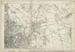
Essex LXXIII - OS Six-Inch Map
1 : 10560 Topographic maps Ordnance Survey Ordnance Survey
Stratford - Le - Bow
1 : 21120 This plan of north east London extends from the Isle of Dogs and Wapping at the bottom, to 'Layton Stone' and Epping Forest at the top. Field boundaries infilled with stripes depict tilled land. Major settlements are drawn in red ink. North of Stoke Newington, to the top left, a road is plotted as a series of fixed points pricked off with dividers and joined by ruled pencil lines. These protractions were made directly from the Ordnance Survey field books. Pencil rays intersect across the map, evidence of measurements taken by the surveyor between fixed triangulation points. Poplar Gut is outlined in red at the Isle of Dogs, the beginnings of the development of the West India Docks.
Plan of the roads and main objects on the eastern part of London : as connected with the tunnel excavating under the Thames from Rotherhithe to Wapping
1 : 48000 Brunel, Marc Isambard, Sir, 1769-1849 H. Teape & Son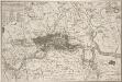
KAART van LONDEN enz en van het NABY GELEGEN LAND ruim een Uur gaans. rondsom dezelve Stad; getrokken uit de groote gemeeten Kaart van de Hr. JOHN ROCQUE, Te AMSTERDAM by ISAAK TIRION 1754
In the second half of the18th century, the introduction of turnpike roads and the increased coach-traffic in and out of London contributed to the popularity of the maps of the countryside around the capital. This map of the area ten miles round the City of London was published in Amsterdam by Isaak Tirion. Based on John Rocque's survey of 1744, the map’s title, imprint and key appears in a table at top left. The scale bars are in a panel below the plan. Built-up areas are stippled in the City and hatched elsewhere. Tirion, Isaak
Kaart van Londen enz. en van het naby gelegen land ruim een uur gaans rondom dezelve stad : getrokken uit de groote gemeeten kaart van de Hr. John Rocque
1 : 63500 Amstersdam : Isaak Tirion
The fourth sheet of an actual survey of the county of Middlesex in which the parishes within the bills of mortality are bounded with red to be distinguished from the others
1 Blatt : 53 x 70 cm John Rocque