Maps of Dover
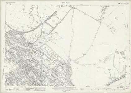
Kent LXVIII.10 (includes: Dover; Guston) - 25 Inch Map
1 : 2500 Topographic maps Ordnance Survey Ordnance Survey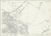
Kent LXVIII.10 (includes: Dover; Guston) - 25 Inch Map
1 : 2500 Topographic maps Ordnance Survey Ordnance Survey
Dover, Kent [fire insurance plan] :sheet 8-4
1 : 480 This detailed 1905 plan of Dover is one of a series of eight sheets in an atlas originally produced to aid insurance companies in assessing fire risks. The building footprints, their use (commercial, residential, educational, etc.), the number of floors and the height of the building, as well as construction materials (and thus risk of burning) and special fire hazards (chemicals, kilns, ovens) were documented in order to estimate premiums. Names of individual businesses, property lines, and addresses were also often recorded. Together these maps provide a rich historical shapshot of the commercial activity and urban landscape of towns and cities at the time. The British Library holds a comprehensive collection of fire insurance plans produced by the London-based firm Charles E. Goad Ltd. dating back to 1885. These plans were made for most important towns and cities of the British Isles at the scales of 1:480 (1 inch to 40 feet), as well as many foreign towns at 1:600 (1 inch to 50 feet). Chas E Goad Limited Chas E Goad Limited
Dover, Kent [fire insurance plan] :sheet 8-5
1 : 480 This detailed 1905 plan of Dover is one of a series of eight sheets in an atlas originally produced to aid insurance companies in assessing fire risks. The building footprints, their use (commercial, residential, educational, etc.), the number of floors and the height of the building, as well as construction materials (and thus risk of burning) and special fire hazards (chemicals, kilns, ovens) were documented in order to estimate premiums. Names of individual businesses, property lines, and addresses were also often recorded. Together these maps provide a rich historical shapshot of the commercial activity and urban landscape of towns and cities at the time. The British Library holds a comprehensive collection of fire insurance plans produced by the London-based firm Charles E. Goad Ltd. dating back to 1885. These plans were made for most important towns and cities of the British Isles at the scales of 1:480 (1 inch to 40 feet), as well as many foreign towns at 1:600 (1 inch to 50 feet). Chas E Goad Limited Chas E Goad Limited
Dover, Kent [fire insurance plan] :Key Plan
1 : 3600 This "key plan" indicates coverage of the Goad 1905 series of fire insurance maps of Dover that were originally produced to aid insurance companies in assessing fire risks. The building footprints, their use (commercial, residential, educational, etc.), the number of floors and the height of the building, as well as construction materials (and thus risk of burning) and special fire hazards (chemicals, kilns, ovens) were documented in order to estimate premiums. Names of individual businesses, property lines, and addresses were also often recorded. Together these maps provide a rich historical shapshot of the commercial activity and urban landscape of towns and cities at the time. The British Library holds a comprehensive collection of fire insurance plans produced by the London-based firm Charles E. Goad Ltd. dating back to 1885. These plans were made for most important towns and cities of the British Isles at the scales of 1:480 (1 inch to 40 feet), as well as many foreign towns at 1:600 (1 inch to 50 feet). Chas E Goad Limited Chas E Goad Limited
Dover, Kent [fire insurance plan] :sheet 2
1 : 480 This detailed 1905 plan of Dover is one of a series of eight sheets in an atlas originally produced to aid insurance companies in assessing fire risks. The building footprints, their use (commercial, residential, educational, etc.), the number of floors and the height of the building, as well as construction materials (and thus risk of burning) and special fire hazards (chemicals, kilns, ovens) were documented in order to estimate premiums. Names of individual businesses, property lines, and addresses were also often recorded. Together these maps provide a rich historical shapshot of the commercial activity and urban landscape of towns and cities at the time. The British Library holds a comprehensive collection of fire insurance plans produced by the London-based firm Charles E. Goad Ltd. dating back to 1885. These plans were made for most important towns and cities of the British Isles at the scales of 1:480 (1 inch to 40 feet), as well as many foreign towns at 1:600 (1 inch to 50 feet). Chas E Goad Limited Chas E Goad Limited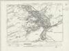
Kent LXVIII.SW - OS Six-Inch Map
1 : 10560 Topographic maps Ordnance Survey Ordnance Survey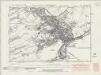
Kent LXVIII.SW - OS Six-Inch Map
1 : 10560 Topographic maps Ordnance Survey Ordnance Survey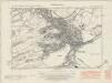
Kent LXVIII.SW - OS Six-Inch Map
1 : 10560 Topographic maps Ordnance Survey Ordnance Survey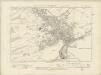
Kent LXVIII.SW - OS Six-Inch Map
1 : 10560 Topographic maps Ordnance Survey Ordnance Survey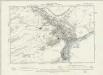
Kent LXVIII.SW - OS Six-Inch Map
1 : 10560 Topographic maps Ordnance Survey Ordnance Survey
Dover Havyn
This is a chart of Dover harbour, likely to be the work of Richard Cavendish. Drawn in inks and watercolour on parchment it depicts improvements to the town, castle and outlying buildings. It was produced by a commission created by Henry VIII in January 1541, who were to "be overseers of the water works at Dover and to procure materials and workmen for the same". It shows protective piers, enclosing almost half of the bay which are to prevent the build up of silt. There is no text to accompany the drawing except for the signatures of the commissioners of the project. In the left-hand margin are measurements in feet. It is thought that this is a show drawing, probably resulting from Henry VIII’s visit in March 1541 or May 1542. It reveals the state of the works with the beach at high and low tide and shows proposals for a vast enlargement of the harbour. Plans for rebuilding the bulwarks at Archcliff and below the castle are also illustrated here. A subsequent addition shows the growth of the beach along the south mole of the enlarged harbour. The initial ideas came from the King himself, however they were to fail as technology was not equal to his demands. The commissioners did not know how to build foundations three and a half fathoms deep at low tide or that the deep water dredging, necessary to keep the harbour open was incompatible with such foundations. A scale bar is included but the units of measurement are not stated Cavendish, Richard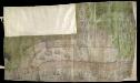
Dover
This is a map of Dover, dating from around 1575-76. In 1576 the navigator and Comptroller of the Navy, William Borough was appointed by Sir Francis Walsingham to report on the state of the harbour, which was commonly known to be in poor condition. Proposals for its repair and remodelling were submitted. This map of Dover is likely to be by John Luckas as it is known from contemporary documents that Luckas drew a plat with a sluice’. (Is sluice shown here?) The draughtsmanship is very fine and much detail is included. The town of Dover is depicted with houses and churches shown individually. The towers, ramparts and internal structures of the castle are carefully rendered. The harbour is protected by a robust round tower on either side of the harbour entrance with cannons placed at intervals and a chain stretched between them. Ships in the harbour are depicted with great care and fly English flags. Luckas, John
Dover, Kent A
This bird's eye view shows Dover harbour in 1581 before the new works of 1582. At this time the harbour was in need of restoration to prevent the build up of silt.The harbour and its immediate surroundings have been drawn to a scale of fifteen poles to an inch with the images of buildings superimposed. The castle is shown in detail, it was the first to make such extensive used of wall towers, a feature that has not escaped the draughtsman. The arms that appear to the left of the drawing are those of Thomas Digges, under whose command as head engineer the new works proceeded. The Crown’s engineers undertook the harbour works. The notes of anchorages have been added at a later date. Digges, Thomas
Dover, Kent B
This coloured bird's eye view shows Dover harbour in 1581 before the new works of 1582. At this time the harbour was in need of restoration to prevent the build up of silt.The harbour and its immediate surroundings have been drawn to a scale of fourteen poles to an inch with the images of buildings superimposed. The castle is shown in detail, it was the first to make such extensive used of wall towers, a feature that has not escaped the draughtsman. The royal arms feature, suggesting that this drawing was submitted to the Queen. Thomas Digges was the head engineer under whose command the new works proceeded. The Crown’s engineers undertook the harbour works. Digges, Thomas
Dover, Kent [fire insurance plan] :sheet 8-2
1 : 480 This detailed 1905 plan of Dover is one of a series of eight sheets in an atlas originally produced to aid insurance companies in assessing fire risks. The building footprints, their use (commercial, residential, educational, etc.), the number of floors and the height of the building, as well as construction materials (and thus risk of burning) and special fire hazards (chemicals, kilns, ovens) were documented in order to estimate premiums. Names of individual businesses, property lines, and addresses were also often recorded. Together these maps provide a rich historical shapshot of the commercial activity and urban landscape of towns and cities at the time. The British Library holds a comprehensive collection of fire insurance plans produced by the London-based firm Charles E. Goad Ltd. dating back to 1885. These plans were made for most important towns and cities of the British Isles at the scales of 1:480 (1 inch to 40 feet), as well as many foreign towns at 1:600 (1 inch to 50 feet). Chas E Goad Limited Chas E Goad Limited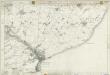
Kent LXVIII - OS Six-Inch Map
1 : 10560 Topographic maps Ordnance Survey Ordnance Survey
Dover (Kent)
The cliffs of Dover are shown almost pictorially on this plan, with dark striations indicating steepness. Relief is shown elsewhere by shading and interlining ('hachuring'). Field boundaries are observed. The sandy coast is represented by a speckled pattern and grassland by a green wash. Dover Castle is seen in plan, with dark hachure lines depicting the steep underlying rocks. The castle, known as the 'Key to England', was a site of unique strategic importance, affording the shortest crossing point of the English Channel to continental Europe. Its defences were improved during the Napoleonic conflicts. Special tunnels were even bored beneath the keep for emergency entrance and exit. This drawing was surveyed while the war was at its most ferocious, yet no batteries are recorded.
St Margaret's Bay
1 : 21120 This rough field sketch of the Kentish coastline was produced on about 12 pieces of thin, irregularly cut, paper which were then joined and laid on thick paper. There is considerable mismatch of detail at the joins. The plan runs from the Strait of Dover, through Dover Castle, St Margaret's Bay, Kingsdown, Walmer Castle and Deal. The red colouring normally used to distinguish buildings in settlement areas was not added to this drawing.
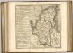
A topographical-map, of the county of Kent, 20
1 Blatt : 54 x 71 cm A. Dury, W. Herbert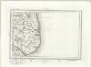
Dover (Outline) - OS One-Inch Revised New Series
1 : 63360 Topographic maps Ordnance Survey Ordnance Survey
Dover (Hills) - OS One-Inch Revised New Series
1 : 63360 Topographic maps Ordnance Survey Ordnance Survey
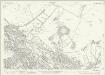
[Ambleteuse - Calais - Pas-de-Calais]
1 Blatt : 60 x 47 cm Brunet s.n.
Carte réduite de la rade des dunes
1 Karte : Kupferdruck ; 56 x 40 cm Bellin s.n.
Partie de l'Angleterre
1 : 110000 Anglie jižní Fricx, Eugene Henry Harrewyn, Jacques chez Eugene Henry Fricx
East Kent - OS One-Inch Map
1 : 63360 Topographic maps Ordnance Survey Ordnance Survey
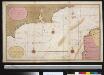
To the Right Honorable the Master, Wardens, and Elder Brethren, of the Trinity House, this chart of the Downs and Margate Roads is ... dedicated
1 : 56000 Heather, W. (William) Heather, W. (William)
Kent, Sheet 31 - Bartholomew's "Half Inch to the Mile Maps" of England & Wales
1 : 126720 Topographic maps Bartholomew, John George John Bartholomew & Co