Maps of Sevenoaks
Kent LX.1 (includes: Penshurst) - 25 Inch Map
1 : 2500 Topographic maps Ordnance Survey Ordnance Survey
Kent LX.1 (includes: Penshurst) - 25 Inch Map
1 : 2500 Topographic maps Ordnance Survey Ordnance Survey
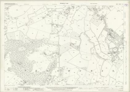
Kent LX.1 (includes: Penshurst) - 25 Inch Map
1 : 2500 Topographic maps Ordnance Survey Ordnance Survey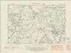
Kent LX.NW - OS Six-Inch Map
1 : 10560 Topographic maps Ordnance Survey Ordnance Survey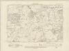
Kent LX.NW - OS Six-Inch Map
1 : 10560 Topographic maps Ordnance Survey Ordnance Survey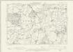
Kent LX.NW - OS Six-Inch Map
1 : 10560 Topographic maps Ordnance Survey Ordnance Survey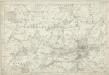
Kent LX - OS Six-Inch Map
1 : 10560 Topographic maps Ordnance Survey Ordnance Survey
TQ54 - OS 1:25,000 Provisional Series Map
1 : 25000 Topographic maps Ordnance Survey Ordnance Survey
Tonbridge (Kent)(002OSD000000005U00352000)
1 : 21120 Drawing showing the area around Tonbridge in Kent. Annotations in ink confirm these drawings as being field sketches. The loose nature of the hill sketching contrasts with that of later, finished drawings. A cross marked Bluborough indicates an observation station from which angular measurements were taken during the surveying.
A topographical-map, of the county of Kent, 11
1 Blatt : 54 x 69 cm A. Dury, W. Herbert
Sevenoaks (Hills) - OS One-Inch Revised New Series
1 : 63360 Topographic maps Ordnance Survey Ordnance Survey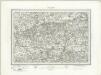
Sevenoaks (Outline) - OS One-Inch Revised New Series
1 : 63360 Topographic maps Ordnance Survey Ordnance Survey
Penshurst (Kent)
1 : 21120 Drawing showing the area to the west of Penshurst in Kent. The lack of hill sketching suggests this is an intermediate version rather than a completed drawing. Woodland is indicated by meticulous renderings of individual trees. Stone walls, indicated in red ink, mark field boundaries. A pest house ("Pest Ho") is noted to the left of Sevenoaks Common. The pest house provided shelter for people afflicted by plague and other infectious diseases at a safe distance from the densely populated town.
A sketch of the roads within fourteen miles of Tunbridge Wells
1 : 100000 Brackett, William Clifford, J J. Clifford
London passenger transport map
Ordnance Survey
London SE - OS One-Inch Map
1 : 63360 Topographic maps Ordnance Survey Ordnance Survey
SVRRIA | Vernacule | SVRREY.
[Amsterdam : Joan Blaeu]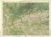
Surrey, Sheet 30 - Bartholomew's "Half Inch to the Mile Maps" of England & Wales
1 : 126720 Topographic maps Bartholomew, John George John Bartholomew & Co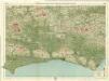
Sussex, Sheet 32 - Bartholomew's "Half Inch to the Mile Maps" of England & Wales
1 : 126720 Topographic maps Bartholomew, John George John Bartholomew & Co
Surria Vernacule Surrey. [Karte], in: Le théâtre du monde, ou, Nouvel atlas contenant les chartes et descriptions de tous les païs de la terre, Bd. 4, S. 173.
1 Karte aus Atlas Blaeu, Willem Janszoon und Blaeu, Joan Blaeu, Willem Janszoon
Surria Vernacule Surrey. [Karte], in: Theatrum orbis terrarum, sive, Atlas novus, Bd. 4, S. 195.
1 Karte aus Atlas Blaeu, Joan Blaeu, Willem Janszoon
Surria Vernacule Surrey. [Karte], in: Theatrum orbis terrarum, sive, Atlas novus, Bd. 4, S. 195.
1 Karte aus Atlas Blaeu, Joan Blaeu, Willem Janszoon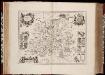
Surria vernacule Surrey / [Joannes Janssonius]
1 : 200000 Annotatie: Oorspr. verschenen in: Ioannis Ianssonii Novus atlas ... - Amstelodami : apud Iohannem Ianssonium, 1646; Origineel is Blad 26 in atlas factice Janssonius, Joannes (jr.) (1588-1664) [Amsterdam : Joannes Janssonius]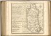

Surria. Vernacule Surrey. [Karte], in: Novus atlas absolutissimus, Bd. 7, S. 148.
1 Karte aus Atlas Janssonius Offizin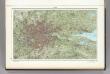
60. London. The World Atlas.
1 : 250000 USSR (Union of Soviet Socialist Republics).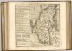
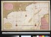
Een gedeelte van het Kanaal van de Hoofden tot den hoek van Bevesier als meede een gedeelte van de cust van Vrankrijk
English Channel Gerard van Keulen
Cantium vernacule Kent
1 : 130000 Amstelodami : apud Joannem Janssonium