Maps of Rother
Sussex LXX.5 (includes: Bexhill; Hooe) - 25 Inch Map
1 : 2500 Topographic maps Ordnance Survey Ordnance Survey
Sussex LXX.5 (includes: Bexhill; Hooe) - 25 Inch Map
1 : 2500 Topographic maps Ordnance Survey Ordnance Survey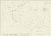
Sussex LXX.5 (includes: Bexhill; Hooe) - 25 Inch Map
1 : 2500 Topographic maps Ordnance Survey Ordnance Survey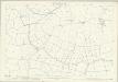
Sussex LXX.5 (includes: Bexhill; Hooe) - 25 Inch Map
1 : 2500 Topographic maps Ordnance Survey Ordnance Survey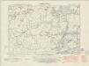
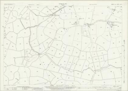
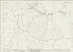
Sussex LXX.NW - OS Six-Inch Map
1 : 10560 Topographic maps Ordnance Survey Ordnance Survey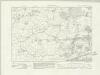
Sussex LXX.NW - OS Six-Inch Map
1 : 10560 Topographic maps Ordnance Survey Ordnance Survey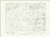
Sussex LXX.NW - OS Six-Inch Map
1 : 10560 Topographic maps Ordnance Survey Ordnance Survey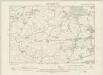
Sussex LXX.NW - OS Six-Inch Map
1 : 10560 Topographic maps Ordnance Survey Ordnance Survey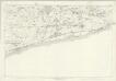
Sussex LXX - OS Six-Inch Map
1 : 10560 Topographic maps Ordnance Survey Ordnance Survey
TQ60 - OS 1:25,000 Provisional Series Map
1 : 25000 Topographic maps Ordnance Survey Ordnance Survey
Hastings 8
1 : 31680 Produced against the background of the Napoleonic Wars, these Ordnance Survey drawings exhibit a hightened interest in defence, particularly along the vulnerable south coast. Military barracks are recorded at Hastings, 'Bopeep' and Bexhill. A faded aquamarine wash defines the coastline from Pevensey Bay to Hastings, with red circles indicating observation stations used to plot the distinctive features of the land being surveyed. Inland, agricultural land (delineated by field boundaries) and woodland dominate the landscape.
Eastbourne - OS One-Inch Map
1 : 63360 Topographic maps Ordnance Survey Ordnance Survey
Hastings - OS One-Inch Map
1 : 63360 Topographic maps Ordnance Survey Ordnance Survey
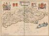
Suthsexia vernacule Sussex
1 Karte : Kupferdruck ; 36 x 49 cm Valck; Schenk apud Gerardum Valk et Petrum Schenk
Svthsexia; vernacule Svssex
1 Karte : Kupferdruck ; 37 x 51 cm Blaeu Joan Blaeu
Kent, Sheet 31 - Bartholomew's "Half Inch to the Mile Maps" of England & Wales
1 : 126720 Topographic maps Bartholomew, John George John Bartholomew & Co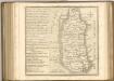
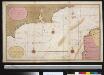
Een gedeelte van het Kanaal van de Hoofden tot den hoek van Bevesier als meede een gedeelte van de cust van Vrankrijk
English Channel Gerard van Keulen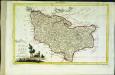
Provincia di Kent
1 Karte : Kupferdruck ; 18 x 29 cm Zatta; Zuliani; Pitteri presso Antonio Zatta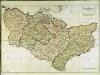
A map of the county of Kent
1 Karte : Kupferdruck ; 49 x 70 cm Kitchin; Dury; Andrews; Herbert A. Dury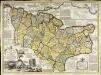
An accurate map of the county of Kent
1 Karte : Kupferdruck ; 50 x 69 cm Bowen; Hinton sold by J. Hinton at the Kings Arms in St. Pauls Church Yard
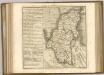
Cantivm vernacule Kent
1 Karte : Kupferdruck ; 37 x 51 cm Blaeu Joan Blaeu
Sheets 17-18. (Cary's England, Wales, and Scotland).
1 : 360000 Cary, John, ca. 1754-1835
Cantium Vernacule Kent. [Karte], in: Novus atlas absolutissimus, Bd. 7, S. 122.
1 Karte aus Atlas Janssonius Offizin
SVTHSEXIA, | Vernacule | SUSSEX.
[Amsterdam : Joan Blaeu]
Suthsexia vernacule Sussex
1 : 240000 Amstelodami : apud Joannem Janssonium
Der Kanal
1 : 150000 Dover (Anglie) Reichs-Marine-Amt
Suthsexia. Vernacule Sussex. [Karte], in: Novus atlas absolutissimus, Bd. 7, S. 137.
1 Karte aus Atlas Janssonius Offizin