Maps of London
Surrey XVIII.4 (includes: Chessington; Epsom) - 25 Inch Map
1 : 2500 Topographic maps Ordnance Survey Ordnance Survey
Surrey XVIII.4 (includes: Chessington; Epsom) - 25 Inch Map
1 : 2500 Topographic maps Ordnance Survey Ordnance Survey
Surrey XVIII.4 (includes: Chessington; Epsom) - 25 Inch Map
1 : 2500 Topographic maps Ordnance Survey Ordnance Survey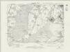
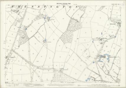
Surrey XVIII.NE - OS Six-Inch Map
1 : 10560 Topographic maps Ordnance Survey Ordnance Survey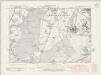
Surrey XVIII.NE - OS Six-Inch Map
1 : 10560 Topographic maps Ordnance Survey Ordnance Survey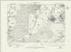
Surrey XVIII.NE - OS Six-Inch Map
1 : 10560 Topographic maps Ordnance Survey Ordnance Survey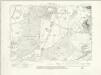
Surrey XVIII.NE - OS Six-Inch Map
1 : 10560 Topographic maps Ordnance Survey Ordnance Survey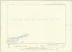
Surrey XVIII.NE - OS Six-Inch Map
1 : 10560 Topographic maps Ordnance Survey Ordnance Survey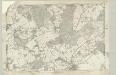
Surrey XVIII - OS Six-Inch Map
1 : 10560 Topographic maps Ordnance Survey Ordnance Survey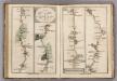
Tooting to Dorking.
1 : 63360 Cary, John
TQ16 - OS 1:25,000 Provisional Series Map
1 : 25000 Topographic maps Ordnance Survey Ordnance Survey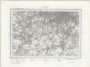
South London (Outline) - OS One-Inch Revised New Series
1 : 63360 Topographic maps Ordnance Survey Ordnance Survey
South London (Hills) - OS One-Inch Revised New Series
1 : 63360 Topographic maps Ordnance Survey Ordnance Survey
Reigate 2
1 : 31680 A dashed black-ink line runs along the boundary of Surrey and Sussex at the bottom of this plan of the North Downs., The bottom right of the manuscript carries a blue- rubber stamp from the 1950s, indicating that the plan was held in the Ordnance Survey Medium and Small Scales Division. Budgen, Thomas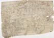
Detail from OSD 127 (Hampton Court), showing Kingston, Richmond and Twickenham
This drawing of London and the surrounding Thames countryside provides a fascinating blueprint of Regency London. The layouts of the ornamental gardens and tree-lined avenues of Hampton Court and nearby Bushy Park are shown in detail. These contrast with the depiction of Kew Gardens, which is left blank within its boundaries. The Ordnance Survey Letter Book records: "When the Ordnance Survey of the vicinity of Brentford was made, The Surveyor was not permitted to enter Kew Gardens." At that time, King George III was recuperating at Kew from bouts of mental illness: the king's privacy and security took primacy over mapmaking. Stanley, William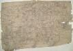
Hampton Court 20
1 : 31680 This drawing of London and the surrounding Thames countryside provides a fascinating blueprint of Regency London. The layouts of the ornamental gardens and tree-lined avenues of Hampton Court and nearby Bushy Park are shown in detail. These contrast with the depiction of Kew Gardens, which is left blank within its boundaries. The Ordnance Survey Letter Book records: "When the Ordnance Survey of the vicinity of Brentford was made, The Surveyor was not permitted to enter Kew Gardens." At that time, King George III was recuperating at Kew from bouts of mental illness: the king's privacy and security took primacy over mapmaking. Stanley, William
Die Environs von London
1 : 470000 Londýn (Anglie)
London passenger transport map
Ordnance Survey
The Environs Of London.
1 : 95000 Colton, G.W.
London environs.
1 : 91500 Society for the Diffusion of Useful Knowledge (Great Britain)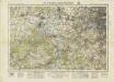
England and Wales [OS of]
Ordnance Survey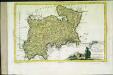
Provincia di Middlesex
1 Karte : Kupferdruck ; 19 x 29 cm Zatta; Zuliani; Pitteri presso Antonio Zatta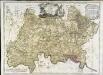
A map of the county of Middlesex
1 Karte : Kupferdruck ; 50 x 68 cm Rocque publish'd according to act of parliament by J. Rocque in the Strand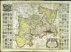
Map of the county of Middlesex
1 Karte : Kupferdruck ; 50 x 50 cm, Bildgrösse 52 x 73 cm Seale s.n.
England & Wales. Diagram of London
Ordnance Survey
London and Environs, Plate 55, V. III
1 : 100000 Bartholomew, John
Middle-Sexia
1 Karte : Kupferdruck ; 37 x 39 cm Blaeu Joan Blaeu
Middle-Sexia. [Karte], in: Le théâtre du monde, ou, Nouvel atlas contenant les chartes et descriptions de tous les païs de la terre, Bd. 4, S. 233.
1 Karte aus Atlas Blaeu, Willem Janszoon und Blaeu, Joan Blaeu, Willem Janszoon
Middle-Sexia. [Karte], in: Theatrum orbis terrarum, sive, Atlas novus, Bd. 4, S. 263.
1 Karte aus Atlas Blaeu, Joan Blaeu, Willem Janszoon