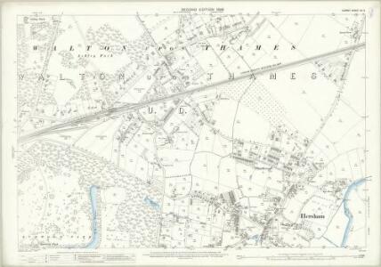
Maps of Elmbridge
Surrey XII.9 (includes: Walton Upon Thames) - 25 Inch Map
1 : 2500 Topographic maps Ordnance Survey Ordnance Survey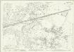
Surrey XII.9 (includes: Walton Upon Thames) - 25 Inch Map
1 : 2500 Topographic maps Ordnance Survey Ordnance Survey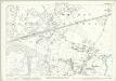
Surrey XII.9 (includes: Walton Upon Thames) - 25 Inch Map
1 : 2500 Topographic maps Ordnance Survey Ordnance Survey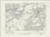
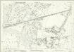
Surrey XII.SW - OS Six-Inch Map
1 : 10560 Topographic maps Ordnance Survey Ordnance Survey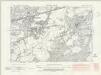
Surrey XII.SW - OS Six-Inch Map
1 : 10560 Topographic maps Ordnance Survey Ordnance Survey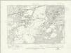
Surrey XII.SW - OS Six-Inch Map
1 : 10560 Topographic maps Ordnance Survey Ordnance Survey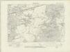
Surrey XII.SW - OS Six-Inch Map
1 : 10560 Topographic maps Ordnance Survey Ordnance Survey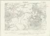
Surrey XII.SW - OS Six-Inch Map
1 : 10560 Topographic maps Ordnance Survey Ordnance Survey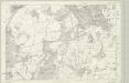
Surrey XII - OS Six-Inch Map
1 : 10560 Topographic maps Ordnance Survey Ordnance Survey
Detail from OSD 127 (Hampton Court), showing Kingston, Richmond and Twickenham
This drawing of London and the surrounding Thames countryside provides a fascinating blueprint of Regency London. The layouts of the ornamental gardens and tree-lined avenues of Hampton Court and nearby Bushy Park are shown in detail. These contrast with the depiction of Kew Gardens, which is left blank within its boundaries. The Ordnance Survey Letter Book records: "When the Ordnance Survey of the vicinity of Brentford was made, The Surveyor was not permitted to enter Kew Gardens." At that time, King George III was recuperating at Kew from bouts of mental illness: the king's privacy and security took primacy over mapmaking. Stanley, William
Hampton Court 20
1 : 31680 This drawing of London and the surrounding Thames countryside provides a fascinating blueprint of Regency London. The layouts of the ornamental gardens and tree-lined avenues of Hampton Court and nearby Bushy Park are shown in detail. These contrast with the depiction of Kew Gardens, which is left blank within its boundaries. The Ordnance Survey Letter Book records: "When the Ordnance Survey of the vicinity of Brentford was made, The Surveyor was not permitted to enter Kew Gardens." At that time, King George III was recuperating at Kew from bouts of mental illness: the king's privacy and security took primacy over mapmaking. Stanley, William
London passenger transport map
Ordnance Survey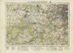
England and Wales [OS of]
Ordnance Survey
Official railway map of London and its environs
1 : 33000 J. & W. Emslie Railway Clearing House
MAP SHEWING THE SEVERAL WALKS OR DELIVERIES IN THE COUNTRY DISTRICTS OF THE TWO PENNY POST, With the Rides to which they are attached numbered to correspond with the figure in the accompanying List
This map was commissioned by the House of Commons for the21st report of the Commissioners of Revenue Inquiry. It title features at top right, with its border divided in degrees of latitude and longitude. Rides and delivery walks in the Two-Penny Country Post are highlighted in colour and numbered for reference. A list of rides and key to delivery walks appears in a table at bottom right. Arrowsmith, Aaron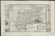
Midlesex
1 : 178000 by H. Moll [London] : [H. Moll etc.]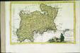
Provincia di Middlesex
1 Karte : Kupferdruck ; 19 x 29 cm Zatta; Zuliani; Pitteri presso Antonio Zatta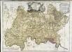
A map of the county of Middlesex
1 Karte : Kupferdruck ; 50 x 68 cm Rocque publish'd according to act of parliament by J. Rocque in the Strand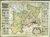
Map of the county of Middlesex
1 Karte : Kupferdruck ; 50 x 50 cm, Bildgrösse 52 x 73 cm Seale s.n.
MIDDLE-SEXIA.
[Amsterdam : Joan Blaeu]
England & Wales. Diagram of London
Ordnance Survey
London and Environs, Plate 55, V. III
1 : 100000 Bartholomew, John
Middle-Sexia
1 Karte : Kupferdruck ; 37 x 39 cm Blaeu Joan Blaeu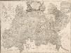
A MAP of the COUNTY of MIDDLESEX Reduced from An Actual Survey in four sheets by John Rocque
The title of this plan appears in decorative cartouche at top centre, with a note on the county's extension and division into parishes at top right. A compass star is included at bottom centre. Scale is given in miles and perches (intervals of around16.5 feet)at bottom left and the border of the map is divided in degrees of longitude from the old meridian of St. Paul's. Symbols are used to indicate land use and reliefs. Rocque, John
Middle-Sexia. [Karte], in: Le théâtre du monde, ou, Nouvel atlas contenant les chartes et descriptions de tous les païs de la terre, Bd. 4, S. 233.
1 Karte aus Atlas Blaeu, Willem Janszoon und Blaeu, Joan Blaeu, Willem Janszoon
Middle-Sexia. [Karte], in: Theatrum orbis terrarum, sive, Atlas novus, Bd. 4, S. 263.
1 Karte aus Atlas Blaeu, Joan Blaeu, Willem Janszoon
Delineatio ac finitima regio Magnae Brittaniae metropoleos Londini
Londýn (Anglie) Seutter, Matthäus a Matt. Seutter
MAP of the COUNTRY 15 MILES ROUND London SHEWING BY A YELLOW CIRCLE OF 3 MILEs, THE LIMITS OF THE TWOPENNY POST DELIVERY
This map was commissioned by the House of Commons for the ninth report of the Post Office Management. The map's title features at top right, with an explanatory note and scale bar at bottom right. It shows the boundaries of the London Two-Penny Post, and the old and current boundaries of the Country Three-Penny Post, with mail routes highlighted in red. Post stages on the edges of the post area allowed mail to be exchanged between the London and the General Post on all main roads out of London. Wyld, James
Middle-Sexia. [Karte], in: Theatrum orbis terrarum, sive, Atlas novus, Bd. 4, S. 263.
1 Karte aus Atlas Blaeu, Joan Blaeu, Willem Janszoon