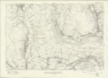
Maps of Caerphilly
Glamorgan XXIX - OS Six-Inch Map
1 : 10560 Topographic maps Ordnance Survey Ordnance Survey
Monmouthshire XXVII - OS Six-Inch Map
1 : 10560 Topographic maps Ordnance Survey Ordnance Survey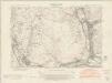
Monmouthshire XXVII.NE - OS Six-Inch Map
1 : 10560 Topographic maps Ordnance Survey Ordnance Survey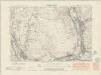
Monmouthshire XXVII.NE - OS Six-Inch Map
1 : 10560 Topographic maps Ordnance Survey Ordnance Survey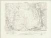
Monmouthshire XXVII.NE - OS Six-Inch Map
1 : 10560 Topographic maps Ordnance Survey Ordnance Survey
Monmouthshire XXVII.NE - OS Six-Inch Map
1 : 10560 Topographic maps Ordnance Survey Ordnance Survey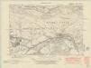
Glamorgan XXIX.SE - OS Six-Inch Map
1 : 10560 Topographic maps Ordnance Survey Ordnance Survey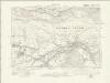
Glamorgan XXIX.SE - OS Six-Inch Map
1 : 10560 Topographic maps Ordnance Survey Ordnance Survey
Glamorgan XXIX.SE - OS Six-Inch Map
1 : 10560 Topographic maps Ordnance Survey Ordnance Survey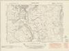
Glamorgan XXIX.NW - OS Six-Inch Map
1 : 10560 Topographic maps Ordnance Survey Ordnance Survey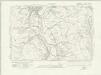
Glamorgan XXIX.NW - OS Six-Inch Map
1 : 10560 Topographic maps Ordnance Survey Ordnance Survey
Glamorgan XXIX.NW - OS Six-Inch Map
1 : 10560 Topographic maps Ordnance Survey Ordnance Survey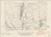
Glamorgan XXIX.SW - OS Six-Inch Map
1 : 10560 Topographic maps Ordnance Survey Ordnance Survey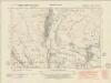
Glamorgan XXIX.SW - OS Six-Inch Map
1 : 10560 Topographic maps Ordnance Survey Ordnance Survey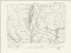
Glamorgan XXIX.SW - OS Six-Inch Map
1 : 10560 Topographic maps Ordnance Survey Ordnance Survey
Glamorgan XXIX.SW - OS Six-Inch Map
1 : 10560 Topographic maps Ordnance Survey Ordnance Survey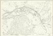
Monmouthshire XXVII.16 (includes: Machen Lower; Machen Upper; Rhyd Y Gwern; Rhydri) - 25 Inch Map
1 : 2500 Topographic maps Ordnance Survey Ordnance Survey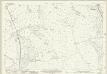
Monmouthshire XXVII.6 (includes: Bedwas; Llanfabon; Mynyddislwyn) - 25 Inch Map
1 : 2500 Topographic maps Ordnance Survey Ordnance Survey
Monmouthshire XXVII.10 (includes: Bedwas; Llanfabon; Mynyddislwyn) - 25 Inch Map
1 : 2500 Topographic maps Ordnance Survey Ordnance Survey
Monmouthshire XXVII.10 (includes: Bedwas; Llanfabon; Mynyddislwyn) - 25 Inch Map
1 : 2500 Topographic maps Ordnance Survey Ordnance Survey
Monmouthshire XXVII.14 (includes: Bedwas; Eglwysilan; Van) - 25 Inch Map
1 : 2500 Topographic maps Ordnance Survey Ordnance Survey
Glamorgan XXIX.5 (includes: Bedwas; Eglwysilan; Llanfabon) - 25 Inch Map
1 : 2500 Topographic maps Ordnance Survey Ordnance Survey
Glamorgan XXIX.9 (includes: Bedwas; Eglwysilan; Llanfabon) - 25 Inch Map
1 : 2500 Topographic maps Ordnance Survey Ordnance Survey
Glamorgan XXIX.9 (includes: Bedwas; Eglwysilan; Llanfabon) - 25 Inch Map
1 : 2500 Topographic maps Ordnance Survey Ordnance Survey
Glamorgan XXIX.13 (includes: Bedwas; Eglwysilan) - 25 Inch Map
1 : 2500 Topographic maps Ordnance Survey Ordnance Survey
Glamorgan XXIX.13 (includes: Bedwas; Eglwysilan) - 25 Inch Map
1 : 2500 Topographic maps Ordnance Survey Ordnance Survey
ST19 - OS 1:25,000 Provisional Series Map
1 : 25000 Topographic maps Ordnance Survey Ordnance Survey
Newport (Hills) - OS One-Inch Revised New Series
1 : 63360 Topographic maps Ordnance Survey Ordnance Survey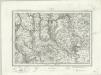
Newport (Outline) - OS One-Inch Revised New Series
1 : 63360 Topographic maps Ordnance Survey Ordnance Survey