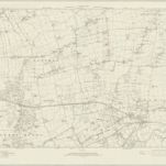
Maps of Basildon

Maps of Basildon

$title$

Essex nLXXXI - OS Six-Inch Map

1 : 10560 Topographic maps Ordnance Survey Ordnance Survey
$title$

Essex nLXXXI.NE - OS Six-Inch Map

1 : 10560 Topographic maps Ordnance Survey Ordnance Survey
$title$

Essex nLXXXI.NE - OS Six-Inch Map

1 : 10560 Topographic maps Ordnance Survey Ordnance Survey
$title$

Essex nLXXXI.SE - OS Six-Inch Map

1 : 10560 Topographic maps Ordnance Survey Ordnance Survey
$title$

Essex nLXXXI.SE - OS Six-Inch Map

1 : 10560 Topographic maps Ordnance Survey Ordnance Survey
$title$

Essex nLXXXI.NW - OS Six-Inch Map

1 : 10560 Topographic maps Ordnance Survey Ordnance Survey
$title$

Essex nLXXXI.NW - OS Six-Inch Map

1 : 10560 Topographic maps Ordnance Survey Ordnance Survey
$title$

Essex nLXXXI.SW - OS Six-Inch Map

1 : 10560 Topographic maps Ordnance Survey Ordnance Survey
$title$

Essex nLXXXI.SW - OS Six-Inch Map

1 : 10560 Topographic maps Ordnance Survey Ordnance Survey
$title$

Essex LXVIII.SE - OS Six-Inch Map

1 : 10560 Topographic maps Ordnance Survey Ordnance Survey
$title$

Essex LXXVI.NE - OS Six-Inch Map

1 : 10560 Topographic maps Ordnance Survey Ordnance Survey
$title$

Hadleigh

This drawing covers Canvey Island. Red triangulation lines are marked, radiating from the centre of settlements and from trigonometrical stations, denoted by the word 'Flag', as at Canvey Point. The draughtsman has shown the channels and sandbanks of the Bemfleet Creek, noting that one bank is only dry at spring tides. A dominant feature of the coastline is the sea wall, represented by a thick grey angular line extending all the way up the creek. Built to protect vulnerable marshland from the sea, the wall benefited from Dutch reclamation work in the 17th century but did not withstand serious floods in 1791, after which further repair work was essential. An Act of Parliament in 1792 established a board of commissioners to build new sections of wall behind the existing one in the places where breaches had occurred. This can be seen on Fobbing Marsh and around Shell Haven Creek in this 1798 drawing. Area calculations appear in the bottom left.
$title$

Essex (New Series 1913-) n LXXXI.8 (includes: Billericay) - 25 Inch Map

1 : 2500 Topographic maps Ordnance Survey Ordnance Survey
$title$

Essex (New Series 1913-) n LXXXI.8 (includes: Billericay) - 25 Inch Map

1 : 2500 Topographic maps Ordnance Survey Ordnance Survey
$title$

Essex (New Series 1913-) n LXXXI.12 (includes: Billericay) - 25 Inch Map

1 : 2500 Topographic maps Ordnance Survey Ordnance Survey
$title$

Essex (New Series 1913-) n LXXXI.12 (includes: Billericay) - 25 Inch Map

1 : 2500 Topographic maps Ordnance Survey Ordnance Survey
$title$

Essex (New Series 1913-) n LXXXI.16 (includes: Billericay) - 25 Inch Map

1 : 2500 Topographic maps Ordnance Survey Ordnance Survey
$title$

Essex (New Series 1913-) n LXXXI.16 (includes: Billericay) - 25 Inch Map

1 : 2500 Topographic maps Ordnance Survey Ordnance Survey
$title$

Essex (New Series 1913-) n LXXXI.3 (includes: Billericay) - 25 Inch Map

1 : 2500 Topographic maps Ordnance Survey Ordnance Survey
$title$

Essex (New Series 1913-) n LXXXI.3 (includes: Billericay) - 25 Inch Map

1 : 2500 Topographic maps Ordnance Survey Ordnance Survey
$title$

Essex (New Series 1913-) n LXXXI.7 (includes: Billericay) - 25 Inch Map

1 : 2500 Topographic maps Ordnance Survey Ordnance Survey
$title$

Essex (New Series 1913-) n LXXXI.7 (includes: Billericay) - 25 Inch Map

1 : 2500 Topographic maps Ordnance Survey Ordnance Survey
$title$

Essex (New Series 1913-) n LXXXI.11 (includes: Billericay) - 25 Inch Map

1 : 2500 Topographic maps Ordnance Survey Ordnance Survey
$title$

Essex (New Series 1913-) n LXXXI.11 (includes: Billericay) - 25 Inch Map

1 : 2500 Topographic maps Ordnance Survey Ordnance Survey
$title$

Essex (New Series 1913-) n LXXXI.15 (includes: Billericay) - 25 Inch Map

1 : 2500 Topographic maps Ordnance Survey Ordnance Survey
$title$

Essex (New Series 1913-) n LXXXI.15 (includes: Billericay) - 25 Inch Map

1 : 2500 Topographic maps Ordnance Survey Ordnance Survey
$title$

Essex (New Series 1913-) n LXXXI.4 (includes: Billericay) - 25 Inch Map

1 : 2500 Topographic maps Ordnance Survey Ordnance Survey
$title$

Essex (New Series 1913-) n LXXXI.4 (includes: Billericay) - 25 Inch Map

1 : 2500 Topographic maps Ordnance Survey Ordnance Survey
$title$

Essex LXIX.SW - OS Six-Inch Map

1 : 10560 Topographic maps Ordnance Survey Ordnance Survey
$title$

Essex (New Series 1913-) n LXXXI.2 (includes: Billericay) - 25 Inch Map

1 : 2500 Topographic maps Ordnance Survey Ordnance Survey
© MapTiler © OpenStreetMap contributors
How does it work?
These instructions will show you how to find historical maps online.
Getting started
Type the place name in the search box to find the exact location. You can further adjust the search by zooming in and out.
Zoom
Zoom in and out with the buttons or use your mouse or touchpad natively.
Exact Area tool
Click here and draw a rectangle over the map to precisely define the search area.
Set filters
Narrow your search with advanced settings, such as Years (from/to), Fulltext, Publisher, etc.
Results
See the results of your search on the right side. You can scroll down to find more maps of this location.
?

Download OldMapsOnline Mobile