Maps of Wrexham
Denbighshire XXXV - OS Six-Inch Map
1 : 10560 Topographic maps Ordnance Survey Ordnance Survey
Denbighshire XXXV.NE - OS Six-Inch Map
1 : 10560 Topographic maps Ordnance Survey Ordnance Survey
Denbighshire XXXV.NE - OS Six-Inch Map
1 : 10560 Topographic maps Ordnance Survey Ordnance Survey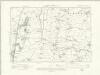
Denbighshire XXXV.NE - OS Six-Inch Map
1 : 10560 Topographic maps Ordnance Survey Ordnance Survey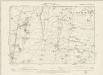
Denbighshire XXXV.NE - OS Six-Inch Map
1 : 10560 Topographic maps Ordnance Survey Ordnance Survey
Denbighshire XXXV.SE - OS Six-Inch Map
1 : 10560 Topographic maps Ordnance Survey Ordnance Survey
Denbighshire XXXV.SE - OS Six-Inch Map
1 : 10560 Topographic maps Ordnance Survey Ordnance Survey
Flintshire XXI.SE - OS Six-Inch Map
1 : 10560 Topographic maps Ordnance Survey Ordnance Survey
Denbighshire XXXV.NW - OS Six-Inch Map
1 : 10560 Topographic maps Ordnance Survey Ordnance Survey
Denbighshire XXXV.NW - OS Six-Inch Map
1 : 10560 Topographic maps Ordnance Survey Ordnance Survey
Denbighshire XXXV.NW - OS Six-Inch Map
1 : 10560 Topographic maps Ordnance Survey Ordnance Survey
Denbighshire XXXV.NW - OS Six-Inch Map
1 : 10560 Topographic maps Ordnance Survey Ordnance Survey
Denbighshire XXXV.SW - OS Six-Inch Map
1 : 10560 Topographic maps Ordnance Survey Ordnance Survey
Denbighshire XXXV.SW - OS Six-Inch Map
1 : 10560 Topographic maps Ordnance Survey Ordnance Survey
Denbighshire XXXV.SW - OS Six-Inch Map
1 : 10560 Topographic maps Ordnance Survey Ordnance Survey
Denbighshire XXXV.SW - OS Six-Inch Map
1 : 10560 Topographic maps Ordnance Survey Ordnance Survey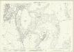
Denbighshire XXXV.14 (includes: Cefn; Chirk; Rhiwabon) - 25 Inch Map
1 : 2500 Topographic maps Ordnance Survey Ordnance Survey
Denbighshire XXXV.13 (includes: Cefn; Chirk; Llangollen Rural) - 25 Inch Map
1 : 2500 Topographic maps Ordnance Survey Ordnance Survey
Shropshire V.4 (includes: Ellesmere Rural; Erbistock; Overton; Rhiwabon) - 25 Inch Map
1 : 2500 Topographic maps Ordnance Survey Ordnance Survey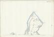
Shropshire V.4 (includes: Ellesmere Rural; Erbistock; Overton; Rhiwabon) - 25 Inch Map
1 : 2500 Topographic maps Ordnance Survey Ordnance Survey
SJ34 - OS 1:25,000 Provisional Series Map
1 : 25000 Topographic maps Ordnance Survey Ordnance Survey
SJ24 - OS 1:25,000 Provisional Series Map
1 : 25000 Topographic maps Ordnance Survey Ordnance Survey
Shropshire V.NE - OS Six-Inch Map
1 : 10560 Topographic maps Ordnance Survey Ordnance Survey
Shropshire V.NE - OS Six-Inch Map
1 : 10560 Topographic maps Ordnance Survey Ordnance Survey
Cyrn y Brain
1 : 31680 The county boundary of Denbighshire and Flintshire is indicated here by a red pecked line. The plan is formally titled, with a note in the top left corner explaining that it has been copied from the original protraction with north facing upwards instead of true. A triangulation diagram appears on the reverse of the drawing: this enabled the draughtsman to plot with prominent topographical features with precision. Many pencil lines radiate from a trigonometrical point at Cefny Fedw, indicated by a dot within a triangle. These represent the angular measurements taken from this point. Giles, John C.
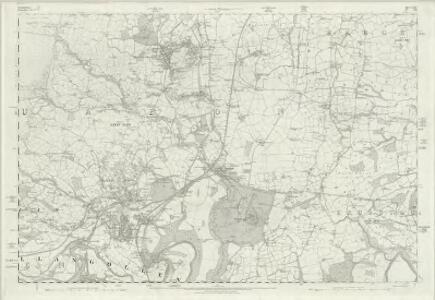
Wrexham (Hills) - OS One-Inch Revised New Series
1 : 63360 Topographic maps Ordnance Survey Ordnance Survey
Wrexham (Outline) - OS One-Inch Revised New Series
1 : 63360 Topographic maps Ordnance Survey Ordnance Survey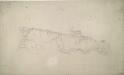
Llangollen
1 : 31680 A triangulation diagram appears on the reverse of this drawing. This enabled draughtsmen to plot the exact location of topographical features. Mileage is indicated on major communication routes, accompanied by abbreviations of the town names from which distance has been measured. For example, the abbreviation 'MS L''2' indicates two miles from Llangollen. Archaeological sites are named in gothic script. A triangulation grid is faintly visible in the left hand portion of the drawing, and pencil lines radiate from trigonometrical stations, marked by dots within triangles. Durrant, William R
Shrewsbury - OS One-Inch Map
1 : 63360 Topographic maps Ordnance Survey Ordnance Survey