Maps of Lancaster
Lancashire XIX.SE - OS Six-Inch Map
1 : 10560 Topographic maps Ordnance Survey Ordnance Survey
Lancashire XIX.SE - OS Six-Inch Map
1 : 10560 Topographic maps Ordnance Survey Ordnance Survey
Lancashire XIX.SE - OS Six-Inch Map
1 : 10560 Topographic maps Ordnance Survey Ordnance Survey
Lancashire XIX.15 (includes: Arkholme With Cawood; Whittington) - 25 Inch Map
1 : 2500 Topographic maps Ordnance Survey Ordnance Survey
Lancashire XIX.16 (includes: Arkholme With Cawood; Cantsfield; Melling With Wrayton; Tunstal; Whittington) - 25 Inch Map
1 : 2500 Topographic maps Ordnance Survey Ordnance Survey
Lancashire XIX.11 (includes: Arkholme With Cawood; Dalton; Hutton Roof; Whittington) - 25 Inch Map
1 : 2500 Topographic maps Ordnance Survey Ordnance Survey
Lancashire XIX.12 (includes: Burrow With Burrow; Tunstal; Whittington) - 25 Inch Map
1 : 2500 Topographic maps Ordnance Survey Ordnance Survey
Westmorland LI.2 (includes: Arkholme With Cawood; Dalton; Priest Hutton; Whittington) - 25 Inch Map
1 : 2500 Topographic maps Ordnance Survey Ordnance Survey
Westmorland LI.2 (includes: Arkholme With Cawood; Dalton; Priest Hutton; Whittington) - 25 Inch Map
1 : 2500 Topographic maps Ordnance Survey Ordnance Survey
Yorkshire XCV.SW & XCV.SE - OS Six-Inch Map
1 : 10560 Topographic maps Ordnance Survey Ordnance Survey
Westmorland XLVII.15 (includes: Hutton Roof; Whittington) - 25 Inch Map
1 : 2500 Topographic maps Ordnance Survey Ordnance Survey
Westmorland XLVII.15 (includes: Hutton Roof; Whittington) - 25 Inch Map
1 : 2500 Topographic maps Ordnance Survey Ordnance Survey
Lancashire XIX - OS Six-Inch Map
1 : 10560 Topographic maps Ordnance Survey Ordnance Survey
Lancashire XIX - OS Six-Inch Map
1 : 10560 Topographic maps Ordnance Survey Ordnance Survey
SD57 - OS 1:25,000 Provisional Series Map
1 : 25000 Topographic maps Ordnance Survey Ordnance Survey
Yorkshire 95 - OS Six-Inch Map
1 : 10560 Topographic maps Ordnance Survey Ordnance Survey
Yorkshire XCV - OS Six-Inch Map
1 : 10560 Topographic maps Ordnance Survey Ordnance Survey
Westmorland LI.NW - OS Six-Inch Map
1 : 10560 Topographic maps Ordnance Survey Ordnance Survey
Westmorland LI.NW - OS Six-Inch Map
1 : 10560 Topographic maps Ordnance Survey Ordnance Survey
Westmorland XLVII.SE - OS Six-Inch Map
1 : 10560 Topographic maps Ordnance Survey Ordnance Survey
Westmorland XLVII.SE - OS Six-Inch Map
1 : 10560 Topographic maps Ordnance Survey Ordnance Survey
Westmorland XLVII.SE - OS Six-Inch Map
1 : 10560 Topographic maps Ordnance Survey Ordnance Survey
Westmorland XLVII.14 (includes: Dalton; Hutton Roof; Whittington) - 25 Inch Map
1 : 2500 Topographic maps Ordnance Survey Ordnance Survey
Westmorland XLVII.14 (includes: Dalton; Hutton Roof; Whittington) - 25 Inch Map
1 : 2500 Topographic maps Ordnance Survey Ordnance Survey
Kirkby Lonsdale (Hills) - OS One-Inch Revised New Series
1 : 63360 Topographic maps Ordnance Survey Ordnance Survey
Kirkby Lonsdale (Outline) - OS One-Inch Revised New Series
1 : 63360 Topographic maps Ordnance Survey Ordnance Survey
Lancaster and Kendal - OS One-Inch Map
1 : 63360 Topographic maps Ordnance Survey Ordnance Survey
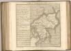
Westmoria comitatvs; anglice Westmorland
1 Karte : Kupferdruck ; 37 x 48 cm Blaeu Joan Blaeu
North Lancashire & Isle of Man, Sheet 5 - Bartholomew's "Half Inch to the Mile Maps" of England & Wales
1 : 126720 Topographic maps Bartholomew, John George John Bartholomew & Co