Maps of Powys

Radnorshire XXXIII.SW - OS Six-Inch Map
1 : 10560 Topographic maps Ordnance Survey Ordnance Survey
Radnorshire XXXIII.SW - OS Six-Inch Map
1 : 10560 Topographic maps Ordnance Survey Ordnance Survey
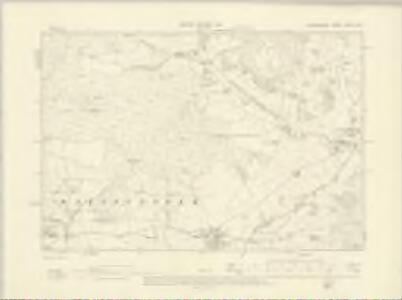
Radnorshire XXXIII.SW - OS Six-Inch Map
1 : 10560 Topographic maps Ordnance Survey Ordnance Survey
Radnorshire XXXIII.13 (includes: Llanbedr Painscastle) - 25 Inch Map
1 : 2500 Topographic maps Ordnance Survey Ordnance Survey
SO14 - OS 1:25,000 Provisional Series Map
1 : 25000 Topographic maps Ordnance Survey Ordnance Survey
Hay (Hills) - OS One-Inch Revised New Series
1 : 63360 Topographic maps Ordnance Survey Ordnance Survey
Hay (Outline) - OS One-Inch Revised New Series
1 : 63360 Topographic maps Ordnance Survey Ordnance Survey
Baulit
1 : 31680 The Wye Valley runs from the top to the bottom of the sheet.Forming a natural border, the valley became a regular battleground throughout the Roman, Saxon Norman eras,and during the Marcher Wars in the reign of James I. To the left of the sheet are the peaks of Mynydd Eppynt. To the right, the border of England and Wales is marked by the ancient earth bank, Offa's Dyke. The castle town of Builth is depicted at the top of the sheet. Built at the end of the 12th century, the castle witnessed repeated conflicts, and frequently changed hands between the Welsh and English. After Edward I's campaign against the Welsh in 1277, the castle was refortified and transformed into a formidable fortress. Budgen, Thomas
Brecon - OS One-Inch Map
1 : 63360 Topographic maps Ordnance Survey Ordnance Survey
RADNORIA | COMITATVS | RADNOR SHIRE.
[Amsterdam : Joan Blaeu]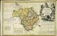
An accurate map of Radnor Shire
1 Karte : Kupferdruck ; 33 x 51 cm Kitchin; Tinney John Tinney
Radnoria comitatvs
1 Karte : Kupferdruck ; 37 x 48 cm Blaeu Joan Blaeu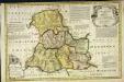
An accurate map of Brecknock Shire
1 Karte : Kupferdruck ; 33 x 50 cm Kitchin; Tinney sold by I. Tinney at the Golden Lion in Fleet street
Comitatvs Brechiniæ
1 Karte : Kupferdruck ; 36 x 49 cm Blaeu Joan Blaeu
Radnoriensis Comitatus vulgo the counties of Radnor
1 : 180000 Amstelodami : apud Joannem Janssonium
Radnoriensis Comitatus Vulgo The Countie of Radnor. [Karte], in: Novus atlas absolutissimus, Bd. 7, S. 381.
1 Karte aus Atlas Janssonius Offizin
Radnoria Comitatus Radnor Shire. [Karte], in: Le théâtre du monde, ou, Nouvel atlas contenant les chartes et descriptions de tous les païs de la terre, Bd. 4, S. 344.
1 Karte aus Atlas Blaeu, Willem Janszoon und Blaeu, Joan Blaeu, Willem Janszoon
Radnoria Comitatus Radnor Shire. [Karte], in: Theatrum orbis terrarum, sive, Atlas novus, Bd. 4, S. 398.
1 Karte aus Atlas Blaeu, Joan Blaeu, Willem Janszoon
Radnoria Comitatus Radnor Shire. [Karte], in: Theatrum orbis terrarum, sive, Atlas novus, Bd. 4, S. 398.
1 Karte aus Atlas Blaeu, Joan Blaeu, Willem Janszoon
COMITATVS | BRECHNIÆ; | BREKNOKE.
[Amsterdam : Joan Blaeu]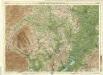
Hereford, Sheet 23 - Bartholomew's "Half Inch to the Mile Maps" of England & Wales
1 : 126720 Topographic maps Bartholomew, John George John Bartholomew & Co
HEREFORDIA | COMITATVS. | HEREFORD-SHIRE.
[Amsterdam : Joan Blaeu]
Comitatus Brechiniae; Breknoke. [Karte], in: Le théâtre du monde, ou, Nouvel atlas contenant les chartes et descriptions de tous les païs de la terre, Bd. 4, S. 347.
1 Karte aus Atlas Blaeu, Willem Janszoon und Blaeu, Joan Blaeu, Willem Janszoon
Comitatus Brechiniae; Breknoke. [Karte], in: Theatrum orbis terrarum, sive, Atlas novus, Bd. 4, S. 401.
1 Karte aus Atlas Blaeu, Joan Blaeu, Willem Janszoon
Comitatus Brechiniae; Breknoke. [Karte], in: Theatrum orbis terrarum, sive, Atlas novus, Bd. 4, S. 401.
1 Karte aus Atlas Blaeu, Joan Blaeu, Willem Janszoon
Herefordia Comitatus. Hereford-Shire. [Karte], in: Theatrum orbis terrarum, sive, Atlas novus, Bd. 4, S. 393.
1 Karte aus Atlas Blaeu, Joan Blaeu, Willem Janszoon
Herefordia Comitatus. Hereford-Shire. [Karte], in: Theatrum orbis terrarum, sive, Atlas novus, Bd. 4, S. 393.
1 Karte aus Atlas Blaeu, Joan Blaeu, Willem Janszoon
Herefordia Comitatus. Hereford-Shire. [Karte], in: Le théâtre du monde, ou, Nouvel atlas contenant les chartes et descriptions de tous les païs de la terre, Bd. 4, S. 339.
1 Karte aus Atlas Blaeu, Willem Janszoon und Blaeu, Joan Blaeu, Willem Janszoon
HEREFORDIAE COMITATUS f.95
This is a map of Herefordshire by Christopher Saxton dating from 1577. It forms part of an atlas that belonged to William Cecil Lord Burghley, Elizabeth I’s Secretary of State. Burghley used this atlas to illustrate domestic matters. This map is actually a proof copy of one which forms part of Christopher Saxton’s Atlas of England and Wales. This atlas was first published as a whole in 1579. It consists of 35 coloured maps depicting the counties of England and Wales. The atlas is of great significance to British cartography as it set a standard of cartographic representation in Britain and the maps remained the basis for English county mapping, with few exceptions, until after 1750. During the reign of Elizabeth I, map use became more common, with many government matters referring to increasingly accurate maps with consistent scales and symbols, made possible by advances in surveying techniques. Illustrating the increasing use of maps in government matters, Lord Burghley, who had been determined to have England and Wales mapped in detail from the 1550s, selected the cartographer Christopher Saxton to produce a detailed and consistent survey of the country. The financier of the project was Thomas Seckford, Master of Requests at the Court of Elizabeth I, whose arms appear, along with the royal crest, on each map. Burghley has annotated this map, underlining the information printed at Kinnaston chap Wch Was dreven downe by the removing of the ground. The map was engraved by Remigius Hogenbergius, one of a team of seven English and Flemish engravers employed to produce the copper plates for the atlas. Saxton, Christopher Hogenbergius, Remigius