Maps of South West England
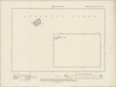
Pembrokeshire XXXIa.SW & XXXIc.SE - OS Six-Inch Map
1 : 10560 Topographic maps Ordnance Survey Ordnance Survey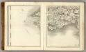
Sheets 19-20. (Cary's England, Wales, and Scotland).
1 : 360000 Cary, John, ca. 1754-1835
Sheet 7 South Wales, uit: Maps of England & Wales : scale 4 miles to 1 inch / Ordnance Survey
1 : 253440 titelvariant: Maps of England and Wales; Annotatie: Titel op cassette; Met bladoverzicht op de achterzijde van de cassette; Annotatie geografische gegevens: Hoogtelijneninterval 200 ft Ordnance Survey, United Kingdom Southampton : Ordnance Survey Office
England and Wales[OS civil air edition]
Ordnance Survey
Principatus Walliae Pars Australis: Vulgo South-Wales. [Karte], in: Novus atlas absolutissimus, Bd. 7, S. 371.
1 Karte aus Atlas Janssonius Offizin
Ireland SE.
1 : 486830 Stanford, Edward
Ireland 4.
1 : 760320 Letts, Son & Co.
WALLIA | PRINCIPATVS | Vulgo WALES.
[Amsterdam : Joan Blaeu]
Watershed map England, Wales 5.
1 : 760320 Letts, Son & Co.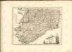

CUMBRIAE TYPUS auctore HVMFREDO LHVYD, Denbigiense Cambrobritanno
This is a map of Wales by Humpfry Lyde, after Ortelius. It forms part of an atlas that belonged to William Cecil Lord Burghley, Elizabeth I’s Secretary of State. Burghley used this atlas to illustrate domestic matters. Lyde, Humpfry
Provinces meridionales de l'Angleterre ou côtes septentrionales de la Manche, 1
1 Blatt : 53 x 68 cm Le Rouge
Comitatus Lageniae = The countie of Leinster
1 : 1200000 Amstelodami : apud Joannem Janssonium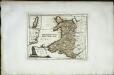
Das Fürstenthum Wales
1 Karte : Kupferdruck ; 19 x 26 cm Reilly F. J. J. von Reilly
Wallia Principatus Vulgo Wales. [Karte], in: Le théâtre du monde, ou, Nouvel atlas contenant les chartes et descriptions de tous les païs de la terre, Bd. 4, S. 336.
1 Karte aus Atlas Blaeu, Willem Janszoon und Blaeu, Joan Blaeu, Willem Janszoon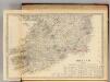
Ireland (south sheet)
1 : 785000 Society for the Diffusion of Useful Knowledge (Great Britain)
Cambriae typus
1 : 780000

Wallia Principatus Vulgo Wales. [Karte], in: Theatrum orbis terrarum, sive, Atlas novus, Bd. 4, S. 390.
1 Karte aus Atlas Blaeu, Joan Blaeu, Willem Janszoon
Wallia Principatus Vulgo Wales. [Karte], in: Theatrum orbis terrarum, sive, Atlas novus, Bd. 4, S. 390.
1 Karte aus Atlas Blaeu, Joan Blaeu, Willem Janszoon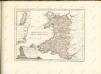

England & Wales SW.
1 : 633600 Stanford, Edward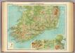
Ireland - southern section.
1 : 633600 John Bartholomew & Co.
England & Wales, south-western section; Scilly Isles.
1 : 633600 John Bartholomew & Co.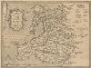
Cambriae Typus [Karte], in: Theatrum orbis terrarum, S. 86.
1 Karte aus Atlas Ortelius, Abraham Vrients, Jan Baptista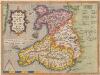
Cambriae Typus [...] [Karte], in: Theatrum orbis terrarum, S. 39.
1 Karte aus Atlas Ortelius, Abraham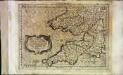
Cornvbia, Devonia, Somersetvs, Dorcestia, Wiltonia, Glocestra Monvmetha, Glamorgan, Caermarden, Penbrok, Cardigan, Radnor, Breknoke, Herefordia, [et] Wigornia
1 Karte : Kupferdruck ; 17 x 24 cm Keere; Mercator Cloppenburgh
Cornvbia, Devonia, Somersetvs, Dorcestria, Wiltonia, Glocestria Monvmetha, Glamorgan, Caermarden, Penbrok, Cardigan, Radnor, Breknoke, Herefordia, [et] Wigornia
1 Karte : Kupferdruck ; 35 x 45 cm Hondius; Mercator Henricus Hondius
Cornvbia, Devonia, Somersetvs, Dorcestria, Wiltonia, Glocestria Monvmetha, Glamorgan, Caermarden, Penbrok, Cardigan, Radnor, Breknoke, Herefordia, [et] Wigornia
1 Karte : Kupferdruck ; 35 x 45 cm Mercator; Hondius Jodocus Hondius