Maps of Neath Port Talbot
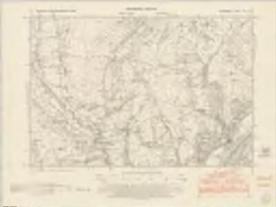
Glamorgan VIII.NE - OS Six-Inch Map
1 : 10560 Topographic maps Ordnance Survey Ordnance Survey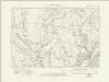
Glamorgan VIII.NE - OS Six-Inch Map
1 : 10560 Topographic maps Ordnance Survey Ordnance Survey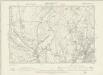
Glamorgan VIII.NE - OS Six-Inch Map
1 : 10560 Topographic maps Ordnance Survey Ordnance Survey
Glamorgan VIII.7 (includes: Llan Giwg; Rhyndwyglydach) - 25 Inch Map
1 : 2500 Topographic maps Ordnance Survey Ordnance Survey
Glamorgan VIII.7 (includes: Llan Giwg; Rhyndwyglydach) - 25 Inch Map
1 : 2500 Topographic maps Ordnance Survey Ordnance Survey
Glamorgan VIII.3 (includes: Llan Giwg; Rhyndwyglydach) - 25 Inch Map
1 : 2500 Topographic maps Ordnance Survey Ordnance Survey
Glamorgan VIII.3 (includes: Llan Giwg; Rhyndwyglydach) - 25 Inch Map
1 : 2500 Topographic maps Ordnance Survey Ordnance Survey
Glamorgan VIII.8 (includes: Cilybebyll; Llan Giwg) - 25 Inch Map
1 : 2500 Topographic maps Ordnance Survey Ordnance Survey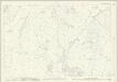
Glamorgan VIII.4 (includes: Llan Giwg) - 25 Inch Map
1 : 2500 Topographic maps Ordnance Survey Ordnance Survey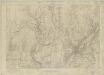
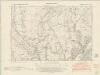
Glamorgan VIII - OS Six-Inch Map
1 : 10560 Topographic maps Ordnance Survey Ordnance Survey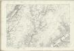
Glamorgan VIII - OS Six-Inch Map
1 : 10560 Topographic maps Ordnance Survey Ordnance Survey
SN70 - OS 1:25,000 Provisional Series Map
1 : 25000 Topographic maps Ordnance Survey Ordnance Survey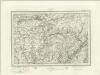
Ammanford (Outline) - OS One-Inch Revised New Series
1 : 63360 Topographic maps Ordnance Survey Ordnance Survey
Ammanford (Hills) - OS One-Inch Revised New Series
1 : 63360 Topographic maps Ordnance Survey Ordnance Survey
Llandovery(002OSD000000021U00146000)
1 : 31680 Towy Valley, the major historic route into west Wales, is depicted at the top of the plan, with a section of the ancient Roman road from Llandovery to Landilo Fawr. Near the bottom of the sheet, dense brushwork is used to describe the peaks of the Black Mountains. Budgen, Thomas
Swansea - OS One-Inch Map
1 : 63360 Topographic maps Ordnance Survey Ordnance Survey
Glamorganensis comitatvs; vulgo Glamorgan Shire
1 Karte : Kupferdruck ; 37 x 49 cm Blaeu Joan Blaeu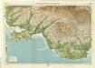
Swansea, Sheet 27 - Bartholomew's "Half Inch to the Mile Maps" of England & Wales
1 : 126720 Topographic maps Bartholomew, John George John Bartholomew & Co
COMITATVS | BRECHNIÆ; | BREKNOKE.
[Amsterdam : Joan Blaeu]
GLAMORGA Comitatu
This map of Glamorgan is from the 1583 edition of the Saxton atlas of England and Wales.This atlas was first published as a whole in 1579. It consists of 35 coloured maps depicting the counties of England and Wales. The atlas is of great significance to British cartography as it set a standard of cartographic representation in Britain and the maps remained the basis for English county mapping, with few exceptions, until after 1750. During the reign of Elizabeth I map use became more common, with many government matters referring to increasingly accurate maps with consistent scales and symbols, made possible by advances in surveying techniques. Illustrating the increasing used of maps in government matters, Lord Burghley, Elizabeth I’s Secretary of State, who had been determined to have England and Wales mapped in detail from the 1550s, selected the cartographer Christopher Saxton to produce a detailed and consistent survey of the country. The financier of the project was Thomas Seckford Master of Requests at the Court of Elizabeth I, whose arms appear, along with the royal crest, on each map. Saxton, Christopher Ryther, Augustine
Comitatus Brechiniae; Breknoke. [Karte], in: Le théâtre du monde, ou, Nouvel atlas contenant les chartes et descriptions de tous les païs de la terre, Bd. 4, S. 347.
1 Karte aus Atlas Blaeu, Willem Janszoon und Blaeu, Joan Blaeu, Willem Janszoon
Comitatus Brechiniae; Breknoke. [Karte], in: Theatrum orbis terrarum, sive, Atlas novus, Bd. 4, S. 401.
1 Karte aus Atlas Blaeu, Joan Blaeu, Willem Janszoon
Comitatus Brechiniae; Breknoke. [Karte], in: Theatrum orbis terrarum, sive, Atlas novus, Bd. 4, S. 401.
1 Karte aus Atlas Blaeu, Joan Blaeu, Willem Janszoon
Glamorganensis Comitatus; Vulgo Glamorgan Shire. [Karte], in: Le théâtre du monde, ou, Nouvel atlas contenant les chartes et descriptions de tous les païs de la terre, Bd. 4, S. 355.
1 Karte aus Atlas Blaeu, Willem Janszoon und Blaeu, Joan Blaeu, Willem Janszoon
Penbrochia comitatus et comitatus Caermaridvnvm
1 Karte : Kupferdruck ; 39 x 51 cm Blaeu Joan Blaeu
GLAMORGANENSIS | COMITATVS; Vulgo | GLAMORGAN SHIRE.
[Amsterdam : Joan Blaeu]
GLAMORGA[N] Comitatus
This is a map of Glamorgan by Christopher Saxton dating from 1578. It forms part of an atlas that belonged to William Cecil Lord Burghley, Elizabeth I’s Secretary of State. Burghley used this atlas to illustrate domestic matters. This map is actually a proof copy of one which forms part of Christopher Saxton’s Atlas of England and Wales. This atlas was first published as a whole in 1579. It consists of 35 coloured maps depicting the counties of England and Wales. The atlas is of great significance to British cartography as it set a standard of cartographic representation in Britain and the maps remained the basis for English county mapping, with few exceptions, until after 1750. During the reign of Elizabeth I, map use became more common, with many government matters referring to increasingly accurate maps with consistent scales and symbols, made possible by advances in surveying techniques. Illustrating the increasing use of maps in government matters, Lord Burghley, who had been determined to have England and Wales mapped in detail from the 1550s, selected the cartographer Christopher Saxton to produce a detailed and consistent survey of the country. The financier of the project was Thomas Seckford, Master of Requests at the Court of Elizabeth I, whose arms appear, along with the royal crest, on each map. Burghley has annotated this map, adding place names, particularly along the coast. At this time England was under threat of invasion from Catholic Spain, a threat which culminated in the events of the Spanish Armada and explains the preoccupation with coastal areas demonstrated here. The map was engraved by one of a team of seven English and Flemish engravers employed to produce the copper plates for the atlas, although the individual engraver is not noted. Saxton, Christopher William Cecil, Lord Burghley
Glamorganensis Comitatus; Vulgo Glamorgan Shire. [Karte], in: Theatrum orbis terrarum, sive, Atlas novus, Bd. 4, S. 409.
1 Karte aus Atlas Blaeu, Joan Blaeu, Willem Janszoon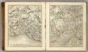
Sheets 21-22. (Cary's England, Wales, and Scotland).
1 : 360000 Cary, John, ca. 1754-1835