Maps of Wrexham
Denbighshire XXIX.SE - OS Six-Inch Map
1 : 10560 Topographic maps Ordnance Survey Ordnance Survey
Flintshire XX.SE - OS Six-Inch Map
1 : 10560 Topographic maps Ordnance Survey Ordnance Survey
Cheshire LIX.NE - OS Six-Inch Map
1 : 10560 Topographic maps Ordnance Survey Ordnance Survey
Cheshire LIX.NE - OS Six-Inch Map
1 : 10560 Topographic maps Ordnance Survey Ordnance Survey
Cheshire LIX.8 (includes: Church Shocklach; Is Y Coed; Shocklach Oviatt; Worthenbury) - 25 Inch Map
1 : 2500 Topographic maps Ordnance Survey Ordnance Survey
Cheshire LIX.8 (includes: Church Shocklach; Is Y Coed; Shocklach Oviatt; Worthenbury) - 25 Inch Map
1 : 2500 Topographic maps Ordnance Survey Ordnance Survey
Denbighshire XXIX.15 (includes: Is Y Coed; Seswick; Worthenbury) - 25 Inch Map
1 : 2500 Topographic maps Ordnance Survey Ordnance Survey
Denbighshire XXIX - OS Six-Inch Map
1 : 10560 Topographic maps Ordnance Survey Ordnance Survey
Cheshire LIX.12 (includes: Church Shocklach; Cuddington; Is Y Coed; Shocklach Oviatt; Worthenbury) - 25 Inch Map
1 : 2500 Topographic maps Ordnance Survey Ordnance Survey
Cheshire LIX.12 (includes: Church Shocklach; Cuddington; Is Y Coed; Shocklach Oviatt; Worthenbury) - 25 Inch Map
1 : 2500 Topographic maps Ordnance Survey Ordnance Survey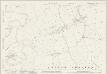
Cheshire LIX.4 (includes: Caldecott; Church Shocklach; Grafton; Is Y Coed; Shocklach Oviatt) - 25 Inch Map
1 : 2500 Topographic maps Ordnance Survey Ordnance Survey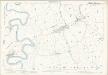
Cheshire LIX.4 (includes: Caldecott; Church Shocklach; Grafton; Is Y Coed; Shocklach Oviatt) - 25 Inch Map
1 : 2500 Topographic maps Ordnance Survey Ordnance Survey
Cheshire LIX.3 (includes: Caldecott; Church Shocklach; Holt; Is Y Coed) - 25 Inch Map
1 : 2500 Topographic maps Ordnance Survey Ordnance Survey
Cheshire LIX.3 (includes: Caldecott; Church Shocklach; Holt; Is Y Coed) - 25 Inch Map
1 : 2500 Topographic maps Ordnance Survey Ordnance Survey
Cheshire LIII.15 & LIX.3 (includes: Caldecott; Church Shocklach; Crewe; Holt; Is Y Coed) - 25 Inch Map
1 : 2500 Topographic maps Ordnance Survey Ordnance Survey
SJ44 - OS 1:25,000 Provisional Series Map
1 : 25000 Topographic maps Ordnance Survey Ordnance Survey
Cheshire LIX.SE - OS Six-Inch Map
1 : 10560 Topographic maps Ordnance Survey Ordnance Survey
Cheshire LIX.SE - OS Six-Inch Map
1 : 10560 Topographic maps Ordnance Survey Ordnance Survey
Cheshire LX.NW - OS Six-Inch Map
1 : 10560 Topographic maps Ordnance Survey Ordnance Survey
Cheshire LX.NW - OS Six-Inch Map
1 : 10560 Topographic maps Ordnance Survey Ordnance Survey
Cheshire LX.5 (includes: Chorlton; Church Shocklach; Horton; Overton; Tilston) - 25 Inch Map
1 : 2500 Topographic maps Ordnance Survey Ordnance Survey
Cheshire LX.5 (includes: Chorlton; Church Shocklach; Horton; Overton; Tilston) - 25 Inch Map
1 : 2500 Topographic maps Ordnance Survey Ordnance Survey
Cheshire LX.9 (includes: Chorlton; Church Shocklach; Cuddington; Horton; Shocklach Oviatt) - 25 Inch Map
1 : 2500 Topographic maps Ordnance Survey Ordnance Survey
Cheshire LX.9 (includes: Chorlton; Church Shocklach; Cuddington; Horton; Shocklach Oviatt) - 25 Inch Map
1 : 2500 Topographic maps Ordnance Survey Ordnance Survey
Cheshire LX.1 (includes: Church Shocklach; Grafton; Horton; Tilston) - 25 Inch Map
1 : 2500 Topographic maps Ordnance Survey Ordnance Survey
Cheshire LX.1 (includes: Church Shocklach; Grafton; Horton; Tilston) - 25 Inch Map
1 : 2500 Topographic maps Ordnance Survey Ordnance Survey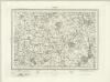
Nantwich (Outline) - OS One-Inch Revised New Series
1 : 63360 Topographic maps Ordnance Survey Ordnance Survey
Nantwich (Hills) - OS One-Inch Revised New Series
1 : 63360 Topographic maps Ordnance Survey Ordnance Survey
Chester 26
1 : 31680 This plan follows the meandering River Dee from Chester, at the top of the map, to Overton and Ruabon, at the bottom left. A section of the Shropshire Union Canal, running from Chester to Waverton, is shown in blue. At the bottom left of the map, an area calculation table survives in black ink. The pencil gridlines running through Chester were most likely guides for making enlarged or reduced copies of the map. Field, John