Maps of Conwy
Denbighshire XXIII.NE - OS Six-Inch Map
1 : 10560 Topographic maps Ordnance Survey Ordnance Survey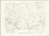
Denbighshire XXIII.NE - OS Six-Inch Map
1 : 10560 Topographic maps Ordnance Survey Ordnance Survey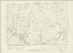
Denbighshire XXIII.NE - OS Six-Inch Map
1 : 10560 Topographic maps Ordnance Survey Ordnance Survey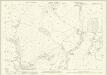
Denbighshire XXIII.8 (includes: Llanrwst Rural; Pentrefoelas) - 25 Inch Map
1 : 2500 Topographic maps Ordnance Survey Ordnance Survey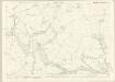
Caernarvonshire XXIV.11 (includes: Eidda; Llanrwst Rural; Penmachno; Pentrefoelas) - 25 Inch Map
1 : 2500 Topographic maps Ordnance Survey Ordnance Survey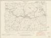
Caernarvonshire XXIV.SE - OS Six-Inch Map
1 : 10560 Topographic maps Ordnance Survey Ordnance Survey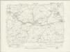
Caernarvonshire XXIV.SE - OS Six-Inch Map
1 : 10560 Topographic maps Ordnance Survey Ordnance Survey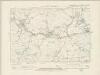
Caernarvonshire XXIV.SE - OS Six-Inch Map
1 : 10560 Topographic maps Ordnance Survey Ordnance Survey
Caernarvonshire XXIV.SE - OS Six-Inch Map
1 : 10560 Topographic maps Ordnance Survey Ordnance Survey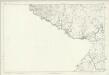
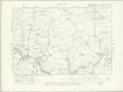
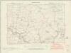
Denbighshire XXIII - OS Six-Inch Map
1 : 10560 Topographic maps Ordnance Survey Ordnance Survey
SH85 - OS 1:25,000 Provisional Series Map
1 : 25000 Topographic maps Ordnance Survey Ordnance Survey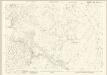
Caernarvonshire XXIV.6 (includes: Llanrwst Rural; Penmachno) - 25 Inch Map
1 : 2500 Topographic maps Ordnance Survey Ordnance Survey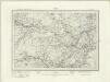
Corwen (Outline) - OS One-Inch Revised New Series
1 : 63360 Topographic maps Ordnance Survey Ordnance Survey
Corwen (Hills) - OS One-Inch Revised New Series
1 : 63360 Topographic maps Ordnance Survey Ordnance Survey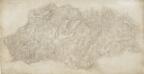
Cernioge Inn
1 : 31680 This plan of the southern fringes of Snowdonia includes the Manod and Moelwyn mountains. The drawing is formally titled, with the scale of the drawing noted and the area of the land recorded as 188.84 square miles. Archaeological sites are named in gothic script. Colour washes depicting relief are combined with numerical annotations ('spot heights') in red and black ink, indicating the heights of hills. Altitudes shown in red have been trigonometrically ascertained; those in black are estimated. Dawson, Robert
Snowdon - OS One-Inch Map
1 : 63360 Topographic maps Ordnance Survey Ordnance Survey
Dolgelley - OS One-Inch Map
1 : 63360 Topographic maps Ordnance Survey Ordnance Survey
DENBIGH AC FLINT Sheet 37
This map of Denbigh and Flint is from the 1583 edition of the Saxton atlas of England and Wales.This atlas was first published as a whole in 1579. It consists of 35 coloured maps depicting the counties of England and Wales. The atlas is of great significance to British cartography as it set a standard of cartographic representation in Britain and the maps remained the basis for English county mapping, with few exceptions, until after 1750. During the reign of Elizabeth I map use became more common, with many government matters referring to increasingly accurate maps with consistent scales and symbols, made possible by advances in surveying techniques. Illustrating the increasing used of maps in government matters, Lord Burghley, Elizabeth I’s Secretary of State, who had been determined to have England and Wales mapped in detail from the 1550s, selected the cartographer Christopher Saxton to produce a detailed and consistent survey of the country. The financier of the project was Thomas Seckford Master of Requests at the Court of Elizabeth I, whose arms appear, along with the royal crest, on each map. Saxton, Christopher Ryther, Augustine
Denbigiensis comitatus et comitatus Flintensis
1 Karte : Kupferdruck ; 36 x 48 cm Blaeu Joan Blaeu
DENBIGIENSIS | Comitatus et Comitatus | FLINTENSIS; | DENBIGH er FLINTSHIRE.
[Amsterdam : Joan Blaeu]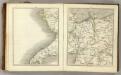
Sheets 38-39. (Cary's England, Wales, and Scotland).
1 : 360000 Cary, John, ca. 1754-1835
DENBIGH AC FLINT f.115
This is a map of Denbigh and Flint by Christopher Saxton dating from 1577. It forms part of an atlas that belonged to William Cecil Lord Burghley, Elizabeth I’s Secretary of State. Burghley used this atlas to illustrate domestic matters. This map is actually a proof copy of one which forms part of Christopher Saxton’s Atlas of England and Wales. This atlas was first published as a whole in 1579. It consists of 35 coloured maps depicting the counties of England and Wales. The atlas is of great significance to British cartography as it set a standard of cartographic representation in Britain and the maps remained the basis for English county mapping, with few exceptions, until after 1750. During the reign of Elizabeth I, map use became more common, with many government matters referring to increasingly accurate maps with consistent scales and symbols, made possible by advances in surveying techniques. Illustrating the increasing use of maps in government matters, Lord Burghley, who had been determined to have England and Wales mapped in detail from the 1550s, selected the cartographer Christopher Saxton to produce a detailed and consistent survey of the country. The financier of the project was Thomas Seckford, Master of Requests at the Court of Elizabeth I, whose arms appear, along with the royal crest, on each map. Burghley has annotated this map, adding place names to the map and notes about the shire towns of Denbigh in the margins. At the time England was under threat of invasion from Catholic Spain, a threat which culminated in the events of the Spanish Armada. Defence of the realm depended on a good geographic and topographic knowledge, explaining Burghley's use of maps and his annotation of them, particularly at locations along the coast. The map was engraved by Remigius Hogenbergius, one of a team of seven English and Flemish engravers employed to produce the copper plates for the atlas. Saxton, Christopher William Cecil, Lord Burghley
Montgomeria comitatus et comitatus Mervinia
1 Karte : Kupferdruck ; 37 x 48 cm Blaeu Joan Blaeu
Comitatvs Caernarvoniensis; vernacule Carnarvon-Shire. et Mona insvla vulgo Anglesey
1 Karte : Kupferdruck ; 36 x 48 cm Blaeu Joan Blaeu
North Wales, Sheet 11 - Bartholomew's "Half Inch to the Mile Maps" of England & Wales
1 : 126720 Topographic maps Bartholomew, John George John Bartholomew & Co
MONTGOMERIA | Comitatus et Comitatus | MERVINIA.
[Amsterdam : Joan Blaeu]
MONTGOMERI
This map of Montgomery is from the 1583 edition of the Saxton atlas of England and Wales.This atlas was first published as a whole in 1579. It consists of 35 coloured maps depicting the counties of England and Wales. The atlas is of great significance to British cartography as it set a standard of cartographic representation in Britain and the maps remained the basis for English county mapping, with few exceptions, until after 1750. During the reign of Elizabeth I map use became more common, with many government matters referring to increasingly accurate maps with consistent scales and symbols, made possible by advances in surveying techniques. Illustrating the increasing used of maps in government matters, Lord Burghley, Elizabeth I’s Secretary of State, who had been determined to have England and Wales mapped in detail from the 1550s, selected the cartographer Christopher Saxton to produce a detailed and consistent survey of the country. The financier of the project was Thomas Seckford Master of Requests at the Court of Elizabeth I, whose arms appear, along with the royal crest, on each map. Saxton, Christopher Ryther, Augustine
Denbigiensis Comitatus et Comitatus Flintensis; Denbigh et Flintshire. [Karte], in: Le théâtre du monde, ou, Nouvel atlas contenant les chartes et descriptions de tous les païs de la terre, Bd. 4, S. 374.
1 Karte aus Atlas Blaeu, Willem Janszoon und Blaeu, Joan Blaeu, Willem Janszoon
Denbigiensis Comitatus et Comitatus Flintensis; Denbigh et Flintshire. [Karte], in: Theatrum orbis terrarum, sive, Atlas novus, Bd. 4, S. 434.
1 Karte aus Atlas Blaeu, Joan Blaeu, Willem Janszoon