Maps of Powys
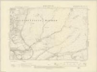
Brecknockshire XLIV.NW - OS Six-Inch Map
1 : 10560 Topographic maps Ordnance Survey Ordnance Survey
Brecknockshire XLIV.NW - OS Six-Inch Map
1 : 10560 Topographic maps Ordnance Survey Ordnance Survey
Brecknockshire XLIV.NW - OS Six-Inch Map
1 : 10560 Topographic maps Ordnance Survey Ordnance Survey
Brecknockshire XLIV.NW - OS Six-Inch Map
1 : 10560 Topographic maps Ordnance Survey Ordnance Survey
Brecknockshire XLIV.NW - OS Six-Inch Map
1 : 10560 Topographic maps Ordnance Survey Ordnance Survey
Brecknockshire XLIV.5 (includes: Ystradfellte; Ystradgynlais Higher) - 25 Inch Map
1 : 2500 Topographic maps Ordnance Survey Ordnance Survey
Brecknockshire XLIV.5 (includes: Ystradfellte; Ystradgynlais Higher) - 25 Inch Map
1 : 2500 Topographic maps Ordnance Survey Ordnance Survey
Brecknockshire XLIV.5 (includes: Ystradfellte; Ystradgynlais Higher) - 25 Inch Map
1 : 2500 Topographic maps Ordnance Survey Ordnance Survey
Brecknockshire XLIV.1 (includes: Glyntawe; Ystradgynlais Higher) - 25 Inch Map
1 : 2500 Topographic maps Ordnance Survey Ordnance Survey
Brecknockshire XLIV.1 (includes: Glyntawe; Ystradgynlais Higher) - 25 Inch Map
1 : 2500 Topographic maps Ordnance Survey Ordnance Survey
Brecknockshire XLIV.1 (includes: Glyntawe; Ystradgynlais Higher) - 25 Inch Map
1 : 2500 Topographic maps Ordnance Survey Ordnance Survey
Brecknockshire XLIV.6 (includes: Ystradfellte; Ystradgynlais Higher) - 25 Inch Map
1 : 2500 Topographic maps Ordnance Survey Ordnance Survey
Brecknockshire XLIV.6 (includes: Ystradfellte; Ystradgynlais Higher) - 25 Inch Map
1 : 2500 Topographic maps Ordnance Survey Ordnance Survey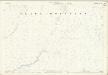
Brecknockshire XLIV.2 (includes: Ystradfellte; Ystradgynlais Higher) - 25 Inch Map
1 : 2500 Topographic maps Ordnance Survey Ordnance Survey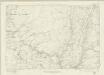
Brecknockshire XLIV - OS Six-Inch Map
1 : 10560 Topographic maps Ordnance Survey Ordnance Survey
Glamorgan IV - OS Six-Inch Map
1 : 10560 Topographic maps Ordnance Survey Ordnance Survey
SN81 - OS 1:25,000 Provisional Series Map
1 : 25000 Topographic maps Ordnance Survey Ordnance Survey
Merthyr Tydfil (Hills) - OS One-Inch Revised New Series
1 : 63360 Topographic maps Ordnance Survey Ordnance Survey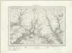
Merthyr Tydfil (Outline) - OS One-Inch Revised New Series
1 : 63360 Topographic maps Ordnance Survey Ordnance Survey
Llandovery 3
1 : 31680 .The Black Mountains dominate this plan of part of,Carmarthenshire, with the toll road from London to Haverfordwest and the Pembrokeshire coast forming the northern boundary. Above the plan, Brynda is indicated as a reference point for triangulation. Near the bottom right, the remains of an old Roman road across the Fawr Forest are indicated by a red double-dotted line. Budgen, Thomas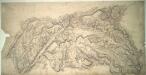
Aberdare
1 : 31680 With 8,000 inhabitants, Merthyr Tydfil was the largest town in Wales during the 19th century. The town, appearing towards the right-hand margin, had access to large supplies of iron and coal, attracting ironmasters and ironworkers from miles away with the promise of high wages and good housing. A network of tramroads, the horse-worked railways that predated the locomotive era, was laid out to transport coal and ore from the pits to the iron works. The drawing indicates these tramroads with double dotted lines. Mines are shown as dots within circles. Budgen, Thomas
Brecon - OS One-Inch Map
1 : 63360 Topographic maps Ordnance Survey Ordnance Survey
Llandovery - OS One-Inch Map
1 : 63360 Topographic maps Ordnance Survey Ordnance Survey
Swansea - OS One-Inch Map
1 : 63360 Topographic maps Ordnance Survey Ordnance Survey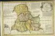
An accurate map of Brecknock Shire
1 Karte : Kupferdruck ; 33 x 50 cm Kitchin; Tinney sold by I. Tinney at the Golden Lion in Fleet street
Comitatvs Brechiniæ
1 Karte : Kupferdruck ; 36 x 49 cm Blaeu Joan Blaeu
Glamorganensis comitatvs; vulgo Glamorgan Shire
1 Karte : Kupferdruck ; 37 x 49 cm Blaeu Joan Blaeu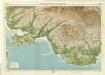
Swansea, Sheet 27 - Bartholomew's "Half Inch to the Mile Maps" of England & Wales
1 : 126720 Topographic maps Bartholomew, John George John Bartholomew & Co
COMITATVS | BRECHNIÆ; | BREKNOKE.
[Amsterdam : Joan Blaeu]