Maps of Anglesey
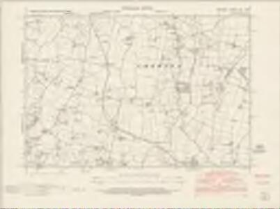
Anglesey XIII.NW - OS Six-Inch Map
1 : 10560 Topographic maps Ordnance Survey Ordnance Survey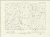
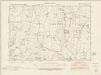
Anglesey XIII.NW - OS Six-Inch Map
1 : 10560 Topographic maps Ordnance Survey Ordnance Survey
Anglesey XIII.NW - OS Six-Inch Map
1 : 10560 Topographic maps Ordnance Survey Ordnance Survey
Anglesey XIII.NW - OS Six-Inch Map
1 : 10560 Topographic maps Ordnance Survey Ordnance Survey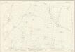
Anglesey XIII.5 (includes: Bodwrog; Coedana; Llandrygarn) - 25 Inch Map
1 : 2500 Topographic maps Ordnance Survey Ordnance Survey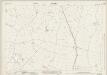
Anglesey XIII.1 (includes: Coedana; Llandrygarn; Llannerch Y Medd; Llechgynfarwy; Rhodogeidio) - 25 Inch Map
1 : 2500 Topographic maps Ordnance Survey Ordnance Survey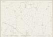
Anglesey XIII.6 (includes: Bodwrog; Coedana; Llandyfrydog; Llangwyllog) - 25 Inch Map
1 : 2500 Topographic maps Ordnance Survey Ordnance Survey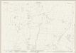
Anglesey XIII.2 (includes: Coedana; Llandyfrydog; Llangwyllog) - 25 Inch Map
1 : 2500 Topographic maps Ordnance Survey Ordnance Survey
SH48 - OS 1:25,000 Provisional Series Map
1 : 25000 Topographic maps Ordnance Survey Ordnance Survey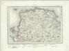
Holyhead (Outline) - OS One-Inch Revised New Series
1 : 63360 Topographic maps Ordnance Survey Ordnance Survey
Holyhead (Hills) - OS One-Inch Revised New Series
1 : 63360 Topographic maps Ordnance Survey Ordnance Survey
Holyhead
1 : 31680 .This plan of north Angelsey runs from Holyhead Bay,on the left, to Red Wharf Bay,on the right., Black-ink numbers,are visible on high spots, indicating the,heights of hills., Archaeological details are noted in black gothic lettering. An area calculation table survives in black ink,in the top left margin. Dawson, Robert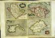
Anglesey
4 Karten auf einem Blatt : Kupferdruck ; je 15 x 21 cm, Bildgrösse 31 x 42 cm Mercator; Hondius Henricus Hondius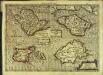
Anglesey
4 Karten auf 1 Blatt : Kupferdruck ; je 9 x 13 cm, Bildgrösse 18 x 25 cm Mercator Cloppenburgh
Anglesey
4 Karten auf einem Blatt : Kupferdruck ; je 15 x 20 cm, Bildgrösse 31 x 42 cm Mercator; Hondius Jodocus Hondius

Anglesey. [Karte], in: Gerardi Mercatoris Atlas, sive, Cosmographicae meditationes de fabrica mundi et fabricati figura, S. 130.
1 Karte aus Atlas Mercator, Gerhard Montanus, Petrus
Anglesey. [Karte], in: Atlas, sive, Cosmographicae meditationes de fabrica mundi et fabricati figura, S. 125.
1 Karte aus Atlas Mercator, Gerhard
Anglesey - OS One-Inch Map
1 : 63360 Topographic maps Ordnance Survey Ordnance Survey
Mona insula vulgo Anglesey ; Mona insula vulgo the Isle of Man ; Vectis insula anglice the Isle of Wight
Amstelodami : apud Joannem Janssonium
Mona Insula Vulgo Anglesey. [Karte], in: Novus atlas absolutissimus, Bd. 8, S. 104.
1 Karte aus Atlas Janssonius Offizin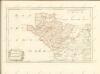
Sheets 38-39. (Cary's England, Wales, and Scotland).
1 : 360000 Cary, John, ca. 1754-1835
Comitatvs Caernarvoniensis; vernacule Carnarvon-Shire. et Mona insvla vulgo Anglesey
1 Karte : Kupferdruck ; 36 x 48 cm Blaeu Joan Blaeu
North Wales, Sheet 11 - Bartholomew's "Half Inch to the Mile Maps" of England & Wales
1 : 126720 Topographic maps Bartholomew, John George John Bartholomew & Co
MONE INSULAE modo Anglesey et Caernaruan
This is a map of Anglesey and Caernarvon by Christopher Saxton dating from 1578. It forms part of an atlas that belonged to William Cecil Lord Burghley, Elizabeth I’s Secretary of State. Burghley used this atlas to illustrate domestic matters. This map is actually a proof copy of one which forms part of Christopher Saxton’s Atlas of England and Wales. This atlas was first published as a whole in 1579. It consists of 35 coloured maps depicting the counties of England and Wales. The atlas is of great significance to British cartography as it set a standard of cartographic representation in Britain and the maps remained the basis for English county mapping, with few exceptions, until after 1750. During the reign of Elizabeth I, map use became more common, with many government matters referring to increasingly accurate maps with consistent scales and symbols, made possible by advances in surveying techniques. Illustrating the increasing use of maps in government matters, Lord Burghley, who had been determined to have England and Wales mapped in detail from the 1550s, selected the cartographer Christopher Saxton to produce a detailed and consistent survey of the country. The financier of the project was Thomas Seckford, Master of Requests at the Court of Elizabeth I, whose arms appear, along with the royal crest, on each map. Burghley has annotated this map, adding place names to the map and notes about the shire towns of Denbigh in the margins. At this time England was under threat of invasion from Catholic Spain, a threat which culminated in the events of the Spanish Armada. Defence of the realm depended on a good geographic and topographic knowledge, explaining Burghley's use of maps and his annotation of them, particularly at locations along the coast. The map was engraved by one of a team of seven English and Flemish engravers employed to produce the copper plates for the atlas, although the individual name is not recorded. Saxton, Christopher Hogenbergius, Remigius
MONE INSULAE
This map of the isle of Man is from the 1583 edition of the Saxton atlas of England and Wales.This atlas was first published as a whole in 1579. It consists of 35 coloured maps depicting the counties of England and Wales. The atlas is of great significance to British cartography as it set a standard of cartographic representation in Britain and the maps remained the basis for English county mapping, with few exceptions, until after 1750. During the reign of Elizabeth I map use became more common, with many government matters referring to increasingly accurate maps with consistent scales and symbols, made possible by advances in surveying techniques. Illustrating the increasing used of maps in government matters, Lord Burghley, Elizabeth I’s Secretary of State, who had been determined to have England and Wales mapped in detail from the 1550s, selected the cartographer Christopher Saxton to produce a detailed and consistent survey of the country. The financier of the project was Thomas Seckford Master of Requests at the Court of Elizabeth I, whose arms appear, along with the royal crest, on each map. Saxton, Christopher Ryther, Augustine
COMITATVS | CAERNARVO- | NIENSIS; | Vernacule | CARNARVON-SHIRE. | ET | MONA INSVLA | Vulgo | ANGLESEY.
[Amsterdam : Joan Blaeu]
Comitatus Caernarvoniensis; Vernacule Carnarvon-Shire. et Mona Insula Vulgo Anglesey. [Karte], in: Theatrum orbis terrarum, sive, Atlas novus, Bd. 4, S. 429.
1 Karte aus Atlas Blaeu, Joan Blaeu, Willem Janszoon