Maps of Ash-cum-Ridley
Kent XXX.NW - OS Six-Inch Map
1 : 10560 Topographic maps Ordnance Survey Ordnance Survey
Kent XXX.NW - OS Six-Inch Map
1 : 10560 Topographic maps Ordnance Survey Ordnance Survey
Kent XXX.NW - OS Six-Inch Map
1 : 10560 Topographic maps Ordnance Survey Ordnance Survey
Kent XXX.NW - OS Six-Inch Map
1 : 10560 Topographic maps Ordnance Survey Ordnance Survey
Kent XXX.NW - OS Six-Inch Map
1 : 10560 Topographic maps Ordnance Survey Ordnance Survey
Kent XXX.1 (includes: Ash; Ridley; Stansted) - 25 Inch Map
1 : 2500 Topographic maps Ordnance Survey Ordnance Survey
Kent XXX.1 (includes: Ash; Ridley; Stansted) - 25 Inch Map
1 : 2500 Topographic maps Ordnance Survey Ordnance Survey
Kent XXX.1 (includes: Ash; Ridley; Stansted) - 25 Inch Map
1 : 2500 Topographic maps Ordnance Survey Ordnance Survey
Kent XXX.5 (includes: Stansted; Wrotham) - 25 Inch Map
1 : 2500 Topographic maps Ordnance Survey Ordnance Survey
Kent XXX.5 (includes: Stansted; Wrotham) - 25 Inch Map
1 : 2500 Topographic maps Ordnance Survey Ordnance Survey
Kent XXX.5 (includes: Stansted; Wrotham) - 25 Inch Map
1 : 2500 Topographic maps Ordnance Survey Ordnance Survey
Kent XXX.2 (includes: Ash; Meopham) - 25 Inch Map
1 : 2500 Topographic maps Ordnance Survey Ordnance Survey
Kent XXX.2 (includes: Ash; Meopham) - 25 Inch Map
1 : 2500 Topographic maps Ordnance Survey Ordnance Survey
Kent XXX.2 (includes: Ash; Meopham) - 25 Inch Map
1 : 2500 Topographic maps Ordnance Survey Ordnance Survey
Kent XXX.6 (includes: Meopham; Trottiscliffe) - 25 Inch Map
1 : 2500 Topographic maps Ordnance Survey Ordnance Survey
Kent XXX.6 (includes: Meopham; Trottiscliffe) - 25 Inch Map
1 : 2500 Topographic maps Ordnance Survey Ordnance Survey
Kent XXX.6 (includes: Meopham; Trottiscliffe) - 25 Inch Map
1 : 2500 Topographic maps Ordnance Survey Ordnance Survey
Kent XXX - OS Six-Inch Map
1 : 10560 Topographic maps Ordnance Survey Ordnance Survey
TQ66 - OS 1:25,000 Provisional Series Map
1 : 25000 Topographic maps Ordnance Survey Ordnance Survey
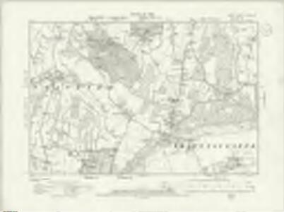
Snodland (Kent)
1 : 10560 Drawing showing the area around Snodland in Kent. This map is drawn on rectangular sheet lines, enclosed by a black border. Fields are coloured brown where cultivated, and green if untilled. Stonework buildings or structures are drawn in red ink. Those made from less permanent materials, such as wood, appear in black or sepia. Corrections have been made on this plan and it is likely that the altitudes ('spot heights') of individual sites of eminence, noted in red-ink figures, are measured rather than merely estimated or sketched.
A topographical-map, of the county of Kent, 7
1 Blatt : 54 x 71 cm A. Dury, W. Herbert
Sevenoaks (Kent) 16
This drawing records the field boundaries and woodland surrounding the towns of Sevenoaks and Kingsdown in Kent. Cultivated land is indicated by a striped pattern, purposely aping the furrows of actual tilled land. Precise instructions for the arrangement of these lines were given in the military manuals. For example, adjacent fields could not have stripes running in the same direction. An 'Old Roman Camp' is recorded on Ightham Common. Pink, George
London passenger transport map
Ordnance Survey
[Kaart], uit: S.E. London & Sevenoaks
1 : 64000 titelvariant: Ordnance Survey contoured road map of S.E. London and Sevenoaks; Annotatie: Omslagtitel: Ordnance Survey contoured road map of S.E. London and Sevenoaks Ordnance Survey Southampton : The Director General, at the Ordnance Survey Office
London SE - OS One-Inch Map
1 : 63360 Topographic maps Ordnance Survey Ordnance Survey

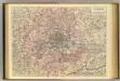
An accurate MAP of the Country TWENTY MILES round LONDON. From GRAVESEND to WINDSOR East and West, and from ST. ALBANS to WESTERHAM North and South with the CIRCUIT of the PENNY POST
In the second half of the18th century, the introduction of turnpike roads and the increased coach-traffic in and out of London contributed to the popularity of the maps of the countryside around the capital. The title of this plan runs along the top, with borders divided in degrees of latitude and longitude, county boundaries outlined in colour and the circuit of the Penny Postmarked in red. Before William Dockwra set up the Penny Post in 1680, there was no local delivery of letters in London, except by private courier. Dockwra opened seven sorting offices and hundreds of receiving houses. Letters were delivered to addresses in London for the charge of a penny, paid by the sender. An extra penny was charged for deliveries in the London Country area within ten miles of the city. In 1682, the Post Office took over the running of the service. Cary, John
Delineatio ac finitima regio Magnae Brittaniae metropoleos Londini
1 : 120000 ad novissimam Normam repraesentata et excusa a T. Conr. Lotter, Augustano Chalcogr. Et Geogr. [Augsburg] : [Tobias Konrad Lotter]
Leigh's new map of the environs of London
1 : 247000 drawn and engraved by Sidy. Hall, 14 Bury St., Bloomsby London : Leigh